1963:015 - TINNAPARK DEMESNE, CO. WICKLOW, Wicklow
County: Wicklow
Site name: TINNAPARK DEMESNE, CO. WICKLOW
Sites and Monuments Record No.: SMR WI013-014SMR WI013-013
Licence number: E1196
Author: PETER DANAHER
Author/Organisation Address: —
Site type: Iron Age and early medieval graves, c. 300 BCc. AD 1200
Period/Dating: —
ITM: E 726183m, N 708601m
Latitude, Longitude (decimal degrees): 53.113034, -6.115160
Introduction
In late October 1963, three lintel graves were discovered in a sand ridge at Tinnapark Demesne, Co. Wicklow, during bulldozing operations to remove the topsod and humus.130 The site was reported to the Archaeology Department in University College Dublin, who informed the NMI. An investigation was carried out by Peter Danaher. Later that year, three further lintel graves were discovered and excavated by Danaher, and in 1964 a seventh cist was excavated. An eighth cist was found in July 1964, some four months after cist 7 was discovered. This had collapsed into the sandpit and was not excavated. The bones from the cist were retained and examined. This report is based on Danaher’s account of the site. The human remains were examined by Professor J.B. Coakley.
Location (Fig. 4.69)
The site was in the townland of Tinnapark Demesne, just under 3km south-west of Delgany, east Co. Wicklow.131 It consisted of a sand ridge, and the graves were found at an altitude of 100–150m above sea level. The first edition of the Ordnance Survey map shows the find-spot within a subcircular enclosure populated with trees. The SMR lists an enclosure close to the north of the site.132 In 1976 a hearth site was found very close to the site, in the same townland. This was investigated by Eamonn Kelly.133
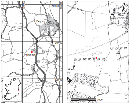
Fig. 4.69—Location map, Tinnapark Demesne, Co. Wicklow.
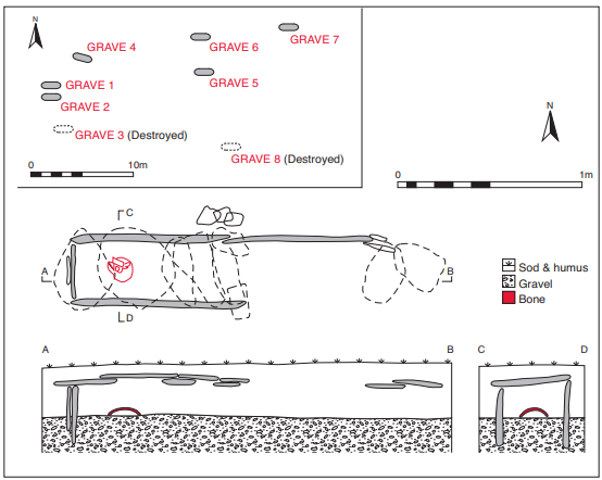
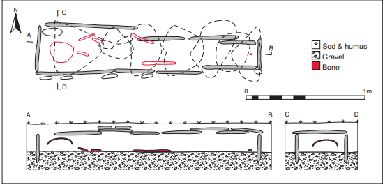
Fig. 4.70—Overall site plan; plan and sections of grave 1, Tinnapark Demesne, Co. Wicklow
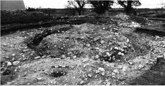
Description of site (Fig. 4.70)
Grave 1
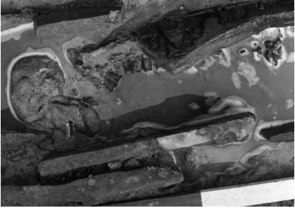
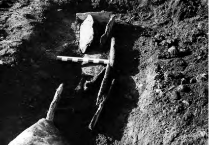
This burial was approximately 0.08m below ground level. The cist was rectangular in plan with its long axis aligned east/west (Fig. 4.70) and measured approximately 1.8m long by 0.32m wide by 0.35m high.134 It was built of large, thin slate slabs set on edge, two forming the north wall, one remaining in the south wall and one at the west end (Pl. 93). All of the slabs were placed directly into the gravel. One of the southern side slabs was missing and there was no end slab at the east. At the latter end two small slabs lay out of line with the northern side slabs.135
At the western end a smaller packing slab was placed outside the end slab. The average height of the side slabs was approximately 0.33m, the average thickness 0.03m, and the maximum length of the slabs was 0.95m. At least five of the lintels were still intact at the western end of the grave, and two at the eastern end. These overlapped slightly with each other, and those at the western end were placed at a slight angle as the northern side was approximately 0.07m higher than that at the southern side. The floor of the cist was not paved.
The cist contained a fill of loose brown humus covering a compact brown soil, which immediately overlay gravel. The burial consisted of portions of an unburnt skull (1963:85) at the western end, and no other bone was located. It is possible that the rest of the bone had disintegrated or had been removed when the cist was discovered. The bones represented the remains of at least one individual, but no further details were obtained. No associated artefacts were found in the grave.
Grave 2
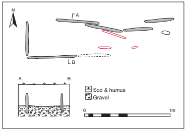
This lay approximately 0.75m south of grave 1. The cist was trapezoidal in plan, with its long
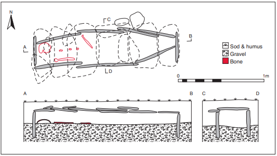
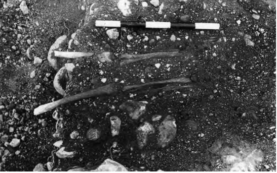
axis aligned east/west (Fig. 4.71). It was in a better state of preservation than cist 1, and all of the side stones and lintels were intact. It measured 1.64m long by 0.32m wide by 0.3m high internally, and tapered sharply to a width of 0.25m at the eastern end. It was constructed of green slate slabs set on edge, each side tilting slightly inwards.136 The northern end was formed of four such slabs and the southern end of three slabs (Pl. 94). Each of the side slabs overlapped slightly so that the wall was well sealed. The maximum length of the slabs was 0.72m and the maximum thickness 0.04m. The ends of the cist were each closed with a single slab. The roof of the cist was covered with six main lintels, some of which overlapped slightly. A number of smaller stones were placed in the interstices between the lintels, and between the lintels and the walls. The floor of the cist was not paved.
The cist contained an inhumation burial of an adult male (1963:86) and no accompanying artefacts were found. The lower levels of the grave were filled with humus, compact brown soil and gravel. A skull and some long bones and vertebrae lay at the western end on the compact soil overlying the gravel. A sample of the human remains was submitted for radiocarbon dating and yielded a date of 1495±40 BP, which calibrates to 436–646.137
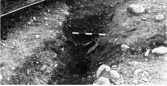
Grave 3
This grave, 3m south of grave 2, was destroyed by the time of Danaher’s visit, but the finders described how slates were found in a rectangular depression aligned west/east. No bones or other finds were noticed in the area.
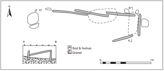
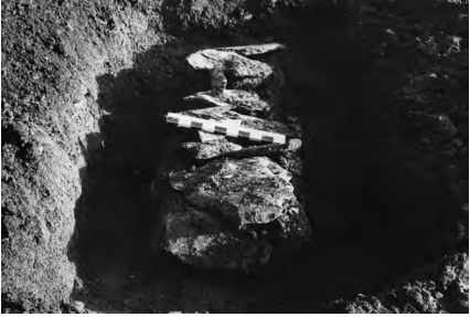
Grave 4
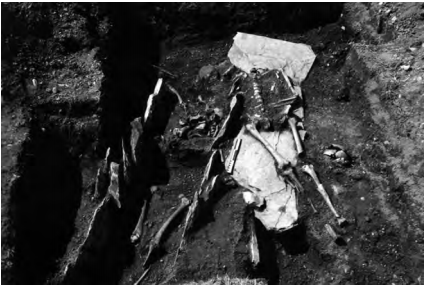
This was located 4m north-west of grave 1. The cist was rectangular in plan, with its long axis aligned east/west. Internally, it measured 1.84m long by 0.32m wide by 0.24m high (Fig. 4.72). It was constructed of thin, edge-set, purple slate slabs with a maximum length of 0.61m, maximum height of 0.24m and maximum thickness of 0.04m. Some of the side walls had out of position, and two of the slabs on the southern side had fallen flat over the human remains. A large boulder acted as an end stone at the eastern end, while the western end was closed by a regular slate slab. Some packing stones were evident outside the southern side of the cist. Most of the lintels were still extant (Pls 95–6). These were irregularly placed in
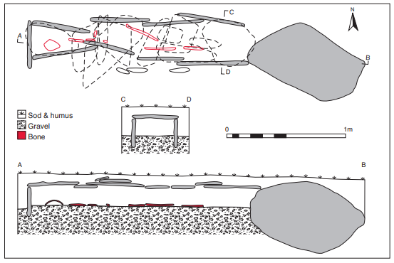
comparison to cists 1 and 2 and overlapped in places. The floor of the cist was not paved. The cist contained an extended inhumation of an adult individual (1963:97) and no accompanying artefacts were found, although a number of charcoal flecks were noted in the grave fill. Some of the bones had decayed, and the best-preserved bones were those where the side slabs had fallen over them. The skeleton lay in a supine position, with the head to the west, on a hard compact soil, which immediately overlay the gravel. A sample of the human remains was submitted for radiocarbon dating and yielded a date of 1405±45 BP, which calibrates to 558–684.138
Grave 5
This cist lay 10m east-south-east of grave 4. It was rectangular in plan, with its long axis aligned east/west. Internally it measured 1.84m long by 0.38m wide by 0.24m high (Fig. 4.73).
The cist was widest at the western end, where it measured 0.35m across, and stepped inwards towards the centre to a narrower width of 0.21m. The grave was constructed of edge-set slate slabs, four forming the north wall and four at the south wall.139 The maximum length of these slabs was 0.8m, the maximum height 0.24m and the maximum thickness 0.04m. Some of the stones on the side walls had tilted out of position, and one on the northern side of the cist had fallen flat into the grave. Each end of the cist was closed with a single slate slab. A few packing stones were evident outside the southern side and one was visible on the northern side. Five main lintels covered the grave. Smaller stones were used in the interstices between the lintels. Most of the grave was covered, apart from a small portion at the western end (Pl. 97). The floor of the cist was not paved.
The cist contained an extended inhumation of an adult individual (1963:98) and no accompanying artefacts were found. The skeleton lay in a supine position with the head to the west. The bones were partly disturbed, probably by a rabbit (rabbit and sheep bones were found in the grave). Most of the human remains lay immediately over the gravel, but the head was at a slightly higher level at the western end.
Grave 6
This lay 3.5m north of grave 5. The cist was probably originally rectangular in plan, with its long axis aligned east/west. It measured approximately 1.7m long by 0.38m wide by 0.24m high (Fig. 4.74).140 Although much of the cist did not survive, it was possible to see that it had
been constructed using thin, edge-set slabs and was probably a lintel grave.141 The northern wall of the cist consisted of four edge-set slabs, some of which were tilted out of position. Only one slab remained in the southern wall; this was the longest in the cist, measuring 0.58m.142 The western end of the cist was closed with a single slab, and no end stone was visible on the eastern side. No lintels were found on the cist. The floor of the cist was not paved. The cist contained a few unburnt human bones (1963:99), and no accompanying artefacts were found. The bones represented the remains of an inhumation burial, but no further details were obtained.
Grave 7
The cist was probably originally subrectangular or trapezoidal in plan, with its long axis running east/west. Internally it measured approximately 1.95m long by 0.4m wide by 0.2m
high (Fig. 4.75). It was formed of thin slate slabs set on edge, overlapping slightly on the northern wall. The maximum length of the slabs was 0.7m, the maximum height 0.02m and the maximum thickness 0.05m. The cist slabs were of purple and green slate. Only one of the southern side slabs survived and this had moved out of position. That a wall had originally existed was evident from the sockets for other side stones. The western end slab and possibly a fourth northern side slab were missing, perhaps removed by a bulldozer. The eastern end was closed by a single shale slab, flanked externally by a small packing stone. A number of packing stones were also visible near the north-eastern corner of the cist, and at the western end. Only two lintels remained in place, one at the north-east corner and a second along the northern wall. The former had fallen so that its end lay inside the southern side stone of the cist. The cist contained no bones, but dark brown patches in the soil possibly indicated their presence. No artefacts were found with the burial.
Grave 8
Very little is known of the structure of this grave, as it was on the verge of the sandpit and undermining and heavy rain caused it to collapse into the pit before investigation. It appears that the cist stones were purple slate slabs, but no further information is available. The grave contained an inhumation burial, which represented the remains of an adult male aged 40 or more years. No associated artefacts were found in the grave.
Comment
Eight graves were excavated at Tinnapark Demesne, most of which were certainly lintel graves. They date from as early as the mid-fifth century. The survival rate of the human remains was very poor, and in some cases only staining in the grave indicated that a burial had existed. Unfortunately, the human remains that did survive were not examined as part of this project. It is likely to be an early medieval familial cemetery that remained in use until at least the seventh century, when burial in consecrated ground became the norm (see pp 5–10 for a discussion on these sites).
Pl. 76—View of part of skeleton, grave 2, in rootball of tree, Loughlinstown, Co. Dublin, July 1991.
Pl. 77—View of skeleton, grave 2, Ballybunnion, Co. Kerry, April 1987.
Pl. 78—View of graves, Mullacash Middle, Co. Kildare, August 1958.
Pl. 79—View of graves, Carrowsteelagh, Co. Mayo, June 1990.
Pl. 80—View of enclosure from south, Durrow Demesne, Co. Offaly, February 1985.
Pl. 81 (left)—View of grave E2, Durrow Demesne, Co. Offaly, February 1985.
Pl. 82 (right)—View of grave 1, Lehinch, Co. Offaly, July 1978.
Pl. 83—View of grave 2, Lehinch, Co. Offaly, July 1978.
Pl. 84 (left)—View of upper levels of grave 3, showing antler pointing downwards on the southern side of the grave, Lehinch, Co. Offaly, July 1978.
Pl. 85 (top right)—Detail of antler at southern edge of grave 3, Lehinch, Co. Offaly, July 1978.
Pl. 86 (bottom right)—View of lower levels of grave 3, showing extended inhumation, Lehinch, Co. Offaly, July 1978.
Pl. 87—View of grave 5, Lehinch, Co. Offaly, July 1978.
Pl. 88—View of ringditch during excavation, Lehinch, Co. Offaly, July 1979.
Pl. 89—View of horse mandible found at the base of the northern
side of the ditch, Lehinch, Co. Offaly, July 1979.
Pl. 90—View of gravel pit, showing early Bronze Age cist, grave 2 (left foreground), and crouched burial, grave 3 (right), Sonnagh Demesne, Co. Westmeath, August 1954.
Pl. 91—View of extended skeleton, grave 1, Sonnagh Demesne, Co. Westmeath, August 1954.
Pl. 92—View of grave 3, crouched inhumation, Sonnagh Demesne, Co. Westmeath, August 1954.
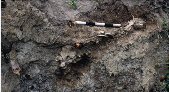
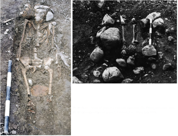
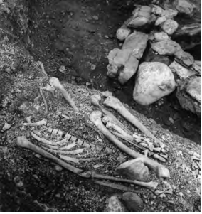
Pl. 93—View of grave 1 from east with skull in situ, Tinnapark Demesne, Co. Wicklow, November 1963.
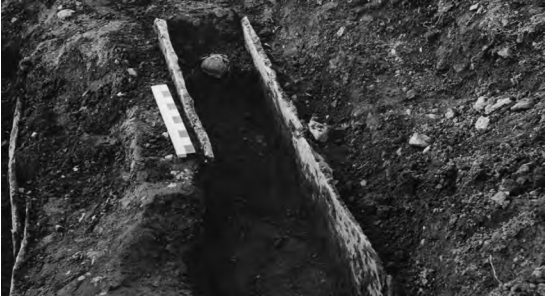
Pl. 94—View of grave 2 from east, Tinnapark Demesne, Co. Wicklow, November 1963.
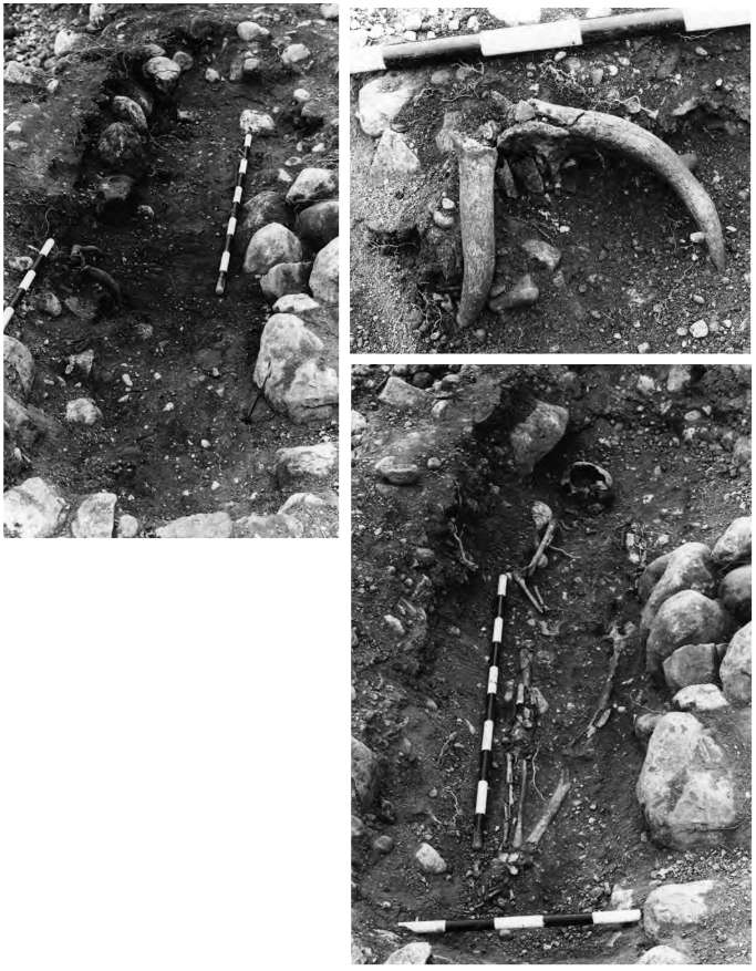
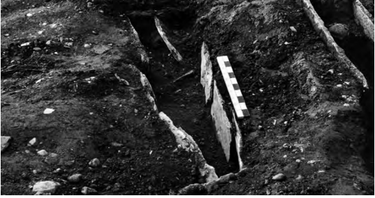
Pl. 95—View of grave 4 from east, showing lintels intact, Tinnapark Demesne, Co. Wicklow, November 1963.
Pl. 96—View of grave 4 from east during excavation, Tinnapark Demesne, Co. Wicklow, November 1963.
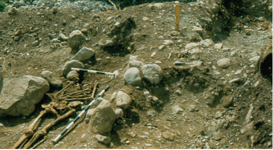
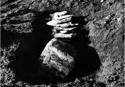
Pl. 97—View of grave 5 from west prior to excavation, Tinnapark Demesne, Co. Wicklow, November 1963.
HUMAN REMAINS
PROFESSOR J.B. COAKLEY
Grave 1 (1963:85)
A number of fragments of human skull bones. They include fragments of frontal, parietal, occipital and temporal bones. There is no evidence to suggest more than one individual.
Grave 2 (1963:86)
Incomplete and broken or fragmented human bones, among which can be recognised skull, vertebrae and limb bones. They appear to belong to a single individual, who was probably a male aged 40+ years.
Skull bones
Portions of frontal, occipital, parietal and temporal bones. They appear to be uniformly thick, and the frontal and temporal bones are disproportionately heavy.
Mandible
Fragments of left half of mandible with two molar and one premolar teeth, all three of which are well worn. In addition, there are fragments of nine teeth, all of which again show considerable wear.
The teeth and mandible are small, suggesting a small face, although there are no facial bones present.
Limb bones
Fragments of a clavicle and scapula. Fragments of right and left humerus, ulna and radius. A small fragment of femur. Various fragments of vertebrae and ribs.
Grave 4 (1963:97)
Various fragments of a skull and limb bones of an adult skeleton. Owing to the fragmentary nature of the bones, it is not possible to draw any further conclusions. The fragments consist of portions of frontal, occipital, left parietal and left temporal bones. There are also fragments of a right femur, a right and left ulna, a radius and tibia. There is also one molar tooth, which shows signs of considerable wear.
Grave 5 (1963:98)
Various fragments of a skull and limb bones of an adult human skeleton. The great wear shown by the molar tooth suggests that the individual was at least middle-aged. This would appear to be a separate individual from 1963:97.
The fragments consist of portions of frontal, parietal, occipital and temporal bones, together with portions of left clavicle, right humerus, right femur and right and left tibia. There is one molar tooth, which is worn to the roots and shows the canals.
Grave 6 (1963:99)
Fragments of human bones, consisting of part of a femur, calcaneus and a number of unidentifiable fragments of limb bones.
Grave 8 (1964:73)
Fragments of skull. Fragments of temporal bones and frontal bones show male characteristics. Fragments of mandible, all teeth present, except left third molar, at death. They show considerable wear. Fragments of upper and lower limb bones, which show male characteristics. Age 40 years plus.
130. A similar lintel grave was excavated in the same townland by Joseph Raftery in 1944. This grave is not included in this report as it is fully published (Raftery 1944a).
131. Parish of Kilcoole, barony of Newcastle. SMR WI013-014——. IGR 326260 208570.
132. SMR WI013-013——. IGR 325370 208390.
133. This feature was located at IGR 326221 208569.
134. As the eastern end stone of the cist was not present, only an estimated length was given.
135. These may be lintels or else smaller side stones that had fallen over.
136. The most westerly of the northern side slabs had tilted inwards recently, probably as a result of the bulldozer activity.
137. GrA-24584.
138. GrA-24787.
139. All of the structural stones were of purple slate.
140. The length given is approximate, as the eastern end stone is missing.
141. All of the cist slabs were of purple slate.
142. The stub of a second stone was also visible.