1961:013 - GLENGAD OR DOONCARTON, CO. MAYO, Mayo
County: Mayo
Site name: GLENGAD OR DOONCARTON, CO. MAYO
Sites and Monuments Record No.: SMR MA004-017
Licence number: —
Author: MAEVE SIKORA
Author/Organisation Address: —
Site type: Iron Age and early medieval graves, c. 300 BCc. AD 1200
Period/Dating: —
ITM: E 482136m, N 838115m
Latitude, Longitude (decimal degrees): 54.278229, -9.809870
Introduction
In February 1961 a lintel grave containing an inhumation was discovered during rockquarrying operations near Belmullet, Co. Mayo. The cist, which lay at approximately 0.46m below ground level, was damaged by a digger on the east and north sides before it was noticed. The site was visited and investigated by Mr Seán Burke of Pollatomais, Ballina. As the site was not investigated by NMI personnel, this report is based on Mr Burke’s written account and sketches of the site. The human remains were examined by Laureen Buckley.
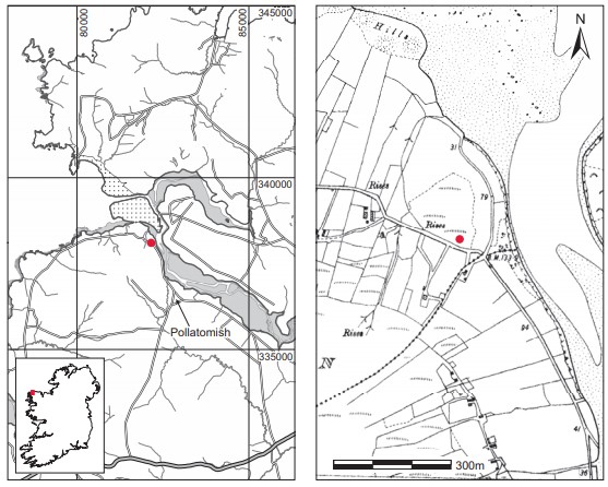
Location (Fig. 4.36)
The site was in the townland of Glengad or Dooncarton, north-west Co. Mayo.80 It was some 1.5km north-west of Pullatomish village on the south side of Sruwaddacon Bay, at an altitude of 44m above sea level. The site lay on the north side of a mountain that rises to 260m above sea level. The area is rich in archaeological remains; two promontory forts, a megalithic tomb and a stone circle all lie within a few kilometres of the site. In 1936 an early Bronze Age cist was excavated at Gortmellia, just 4km to the south-west of this site (Vol. 1, pp 317–29).
Description of site
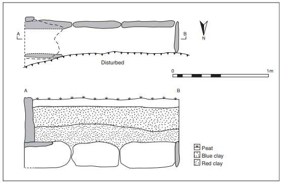
The cist was rectangular in plan, with its long axis aligned east/west. From the surviving portion of the cist—the southern side and both ends—it was possible to estimate that it measured at least 1.65m long by 0.31m wide by 0.27m high (Fig. 4.37).81 The surviving side of the cist was formed of five edge-set slabs, and the western end was closed with a single slab. The eastern end was obscured by two overlapping lintels. The cist slabs were thought by Burke not to be of sandstone but of some other local material obtained from the seashore, which was only 250m away. The slabs appear to have been relatively regular in shape, with the maximum length being 0.61m and the maximum thickness 0.08m. There is no evidence in Burke’s plans for packing stones around the cist, and the floor of the cist was not paved. Only two lintels are illustrated in Burke’s plan and section, but according to his first report the roof of the cist was composed of a number of overlapping ‘flagstones’. The illustration and notes supplied by Burke show that a 0.15m-thick stratum of peat followed by a stratum of ‘blue clay’ overlay a stratum of red (sandstone) clay, into which the original pit for the cist had been dug. The grave contained the unburnt remains of an adult individual (1961:138) and no accompanying artefacts were found. The remains had been disturbed by the time of Burke’s visit, and only a portion of the cranium, upper jaw and seven teeth were recovered.
Comment
As is the case with Creevagh, this site was not examined by NMI personnel. An early medieval date has been attributed to this grave on the basis of its form.
Description of bone (1961:138)
One large fragment of cranium survived and it consisted of most of the frontal bone and most of both parietal bones. The supraorbital ridges were not present and there was no means of sexing the skull. The sutures were fused endocranially but only slightly fused ectocranially. Most of the left side of the maxilla and a small amount of the right side of the maxilla was also present.
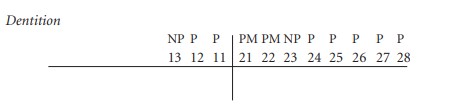
The canines may not have developed properly. An X-ray would be needed to determine whether part of the roots or an undeveloped tooth bud is present in the jaw. Since both teeth are missing, however, they are likely to be congenitally absent.
The first left premolar has rotated slightly clockwise. The teeth were in poor condition, with the enamel cracked and flaking off.
Attrition: there was moderate wear on the incisors and premolars and very heavy wear on the first molars, with very little enamel left on the occlusal surface.
Calculus: deposits were slight on the buccal surfaces of the premolars and first molars and the lingual surfaces of the right lateral incisor and left first premolar.
Periodontal disease: there was a slight degree of alveolar recession around most teeth
Summary and conclusions
This appeared to represent the remains of an adult inhumation of unknown sex. Only the skull, maxilla and seven teeth were present. There was a possibility that the canine teeth had not developed; this is quite a rare anomaly. The heavy wear on the first molar suggests that this may have been an older individual, although that conclusion is tenuous as only three out of twelve molars were present for observation.
80. Parish of Kilcommon, barony of Erris. SMR MA004-017——. IGR 082160 338110.
81. This is the second set of measurements taken by Seán Burke, which he states to be more accurate than the
first. Internal measurements were not taken here as the presence of lintels would have obscured the true
dimensions.