1960:015 - DUNMORE, CO. DONEGAL, Donegal
County: Donegal
Site name: DUNMORE, CO. DONEGAL
Sites and Monuments Record No.: SMR DG027-025
Licence number: E1051
Author: BREANDÁN Ó RÍORDÁIN
Author/Organisation Address: —
Site type: Early Bronze Age graves
Period/Dating: —
ITM: E 637400m, N 912261m
Latitude, Longitude (decimal degrees): 54.956610, -7.416093
Introduction
In late March 1960 a pit containing a cremation was discovered during ploughing on a farm near Carrowkeel, Co. Donegal, when the plough struck its capstone approximately 0.15m below ground level. The capstone was not moved but the pit underneath was investigated and some of the contents, including cremated bone, were removed. This bone was taken home by the landowner, John McGrory, and later thrown in the fire. A few fragments had also been given to Samuel Kerr, a local newspaper correspondent, who forwarded them to the NMI. The site was investigated on 31 March by Breandán Ó Ríordáin. This report is based on Ó Ríordáin’s site report and drawings.
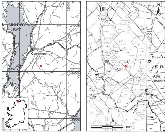
Location (Fig. 3.36)
The site was in the townland of Dunmore, on the Fanad peninsula in north County Donegal, east of Mulroy Bay.57 A standing stone is also recorded in the townland. Some 10m south-west of the pit another large slab of somewhat similar dimensions had been partially uncovered by the landowner. This area was also investigated with trial cuttings around the sides of the slab (which was too large to remove) but did not prove to be a burial.
Description of site
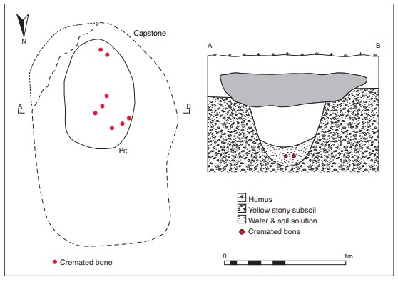
The grave consisted of an oval pit covered with a large oval capstone. Owing to its weight, the capstone of the cist had not been moved from its original position and it was not possible to remove it during the excavation. It measured 1.85m by 1.25m by 0.07m thick (maximum dimensions) (Fig. 3.37). It covered a concave pit measuring 0.9m in maximum length by 0.6m in maximum width by 0.5m in maximum depth. The pit had been dug out of compact yellow subsoil. No cist structure or slabs were found at the sides or base of the pit. The grave contained the cremated remains of at least one adult (1960:402) and no accompanying artefacts were found. The cremation was contained within the waterlogged deposit within the pit.
Comment
The human remains from this site have not been dated. There were no accompanying ceramics or other datable objects and it is assumed on the basis of its morphology that the Pelvis
site dates from the early Bronze Age. The report on the cremated bone notes that a shell was found with it. This is another instance of the discovery of shells with cist and pit burials. Other sites in this corpus include Stillorgan Park, Co. Dublin, Annaghkeen, Co. Galway, Kinard, Co. Mayo, Carrigeens, Co. Sligo, and Clonickilvant, Co. Westmeath.
HUMAN REMAINS
LAUREEN BUCKLEY
Introduction This sample (1960:402) consisted of 53 fragments of cremated bone, weighing a total of 36g. The bone was a very white colour with a slightly chalky texture and was efficiently cremated. Some of the larger fragments had horizontal fissuring on their surface. The fragmentation of the sample is given in Table 3.18a, with the largest fragment being 49mm in length.
Table 3.18a—Fragmentation table, 1960:402
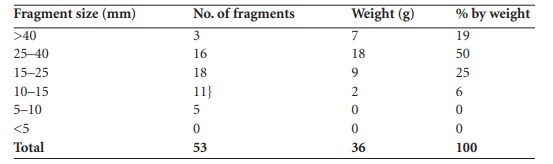
Obviously the total weight of the sample is nowhere near the weight of a full adult cremation, which could weigh between 1,600g and 3,000g, since most of it was removed before it could be excavated properly. In fact, since this sample could be as little as 1–2% of the total cremation that was originally present, there is probably little point in drawing any conclusions about the fragmentation. Most of this sample consisted of large fragments but that does not mean that most of the original sample consisted of larger fragments.
Identifiable bone
A total of 15g (42% of the total bone) was identified.
Table 3.18b—Proportion of identified bone, 1960:402.
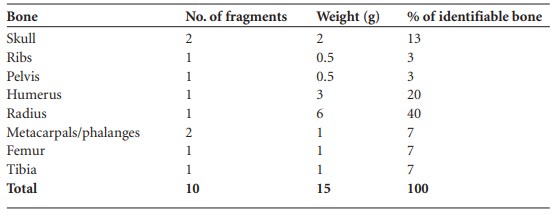
Again, although it is obvious that there was originally at least one full cremation in this pit since many different bones were present, there is little point in discussing the proportion of skeletal remains from so small a sample. One additional fragment of one bone would make a significant difference to the proportion of that bone or limb in the overall sample.
Description of identifiable features of the bones
Skull
Most of the skull fragments were fragments of parietal bone that were split through the diploe.
Ribs
One fragment of shaft that was very decayed.
Pelvis
One possible fragment of ilium.
Humerus
This consisted of one large fragment of proximal shaft only.
Radius
A large fragment of shaft was present.
Metacarpals and phalanges
Most of a first metacarpal and part of the shaft of one other metacarpal was present.
Femur
One fragment of shaft only.
Tibia
One fragment of shaft only
Summary and conclusions
This sample was only a small part of the original cremation. It seemed to represent at least one adult, as many but not all parts of the skeleton were present. There was insufficient information to determine the sex and age of the individual. A shell was also present with the cremated bone.
57. OS 6in. sheet 27. Parish of Tullyfern, barony of Kilmacrenan. The site is listed as Dunmore by Lacey (1983, 66) as OS 6in. sheet 27 but its exact location is not marked. The NMI topographical file records the coordinates as 3.7cm from south and 1.3cm from east. These figures are incorrect and will not produce a location within the townland of Dunmore. To complicate matters further, there are three townlands of Dunmore spread across OS 6in. sheets 25, 26, 27 and 28. The topographical file makes it clear, however, that the landowner’s postal address is Dunmore, Carrowkeel, which is the townland on sheets 27 and 28. It is also noted on the file that there is a standing stone in the same field as the cist. The second edition OS 6in. sheet does not show a standing stone in the townland but the first edition records ‘Standing Stone’ in the townland of Dunmore in the Electoral District of Carrowkeel. The recorded coordinates should most likely have been 13.7cm and 1.3cm. This point, when plotted, is slightly south-east of the field with the standing stone, but there can be no doubt that this is the field intended to be recorded as the find-place. The Donegal survey does not record this standing stone. The SMR for County Donegal records a ‘standing stone—site o