1960:014 - CARRONTLIEVE, CO. DONEGAL, Donegal
County: Donegal
Site name: CARRONTLIEVE, CO. DONEGAL
Sites and Monuments Record No.: SMR DG038-016
Licence number: E1050
Author: BREANDÁN Ó RÍORDÁIN
Author/Organisation Address: —
Site type: Early Bronze Age graves
Period/Dating: —
ITM: E 634668m, N 925927m
Latitude, Longitude (decimal degrees): 55.079588, -7.457076
Introduction
On 10 February 1960, during probing for a well, a short cist was discovered in the back garden of a dwelling house 6km south of Buncrana, Co. Donegal. On further investigation the landowner, Mr William McLoughlin, discovered four additional cists. Apparently four of the cists lay ‘at a depth of several feet’ and had contained water when found. The landowner partly removed the capstones of all five cists but did not otherwise interfere with them. He informed the local rector and Mr H.P. Swan, a local antiquarian and collector, who advised him to suspend work at the site until the cists had been examined. Mr Swan then wrote to the NMI reporting the find, and also informed the Garda Síochána. The site was investigated by Breandán Ó Ríordáin over a period of four days from 15 to 18 February 1960. A sixth cist was discovered during Ó Ríordáin’s excavations at the site. This report is based on Ó Ríordáin’s drawings and report and on Professor J.B. Coakley’s report on the human remains.
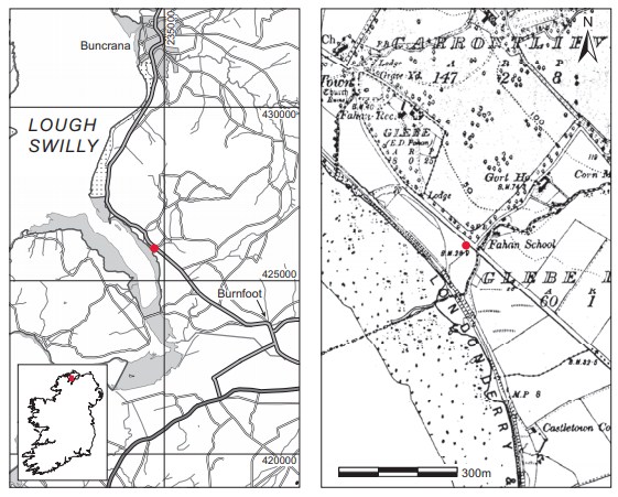
Location (Fig. 3.34)
The site is in the townland of Carrontlieve, in the south-west corner of the Inishowen peninsula, Co. Donegal.53 The cemetery lay on flat land close to the eastern shore of Lough Swilly at an altitude of less than 15m above sea level. No stone cairn or earthen mound was noticeable when the site was visited.

Description of site
Grave 1
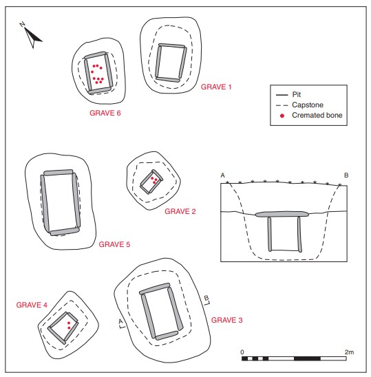
This cist was discovered at a depth of 0.65m below ground level. It was rectangular in plan, with its long axis aligned north-east/south-west. Internally it measured 0.6m long by 0.4m wide by 0.47m high (Fig. 3.35).54 The sides were formed of four main slabs set on edge, with one forming each side of the cist. The maximum length of these side slabs was 0.6m and their maximum thickness 0.075m. There was no evidence of packing stones outside the cist walls. The capstone of the cist, which had been partly removed by the landowner, measured 1.25m long by 0.82m wide by 0.14m thick, considerably larger than the cist it covered. There was no floor slab in the cist. The pit dug to receive the cist was 1.5m long by 1.1m wide. The cist contained some 0.12m of waterlogged soil at its base but no human remains or artefacts were found within.

Grave 2
This cist was located approximately 1m south-west of grave 1 and was discovered at a depth of 0.47m below ground level. It was rectangular in plan, with its long axis aligned east/west. Internally it measured 0.35m long by 0.33m wide by 0.35m deep (Fig. 3.35). It was composed of four edge-set slabs, one forming each side. These slabs appear to have been relatively regular in form, with a maximum thickness of 0.05m and a maximum length of 0.35m. There was no evidence of packing stones outside the cist, nor was it paved. The capstone, partially removed by the landowner, was irregular in outline, measuring 0.83m long by 0.8m wide by 0.08m thick. The pit dug to receive the cist was almost square in plan, measuring 0.95m by 1m. A small amount of cremated bone55 was discovered at the north-eastern end of the cist, and no accompanying artefacts were found. As the bone only comprised a few fragments of cremated skull and ‘limb bones’, it was not possible for the anatomist to identify the number of individuals present, their age or sex.
Grave 3
This cist lay approximately 5m south-west of grave 1 at a depth of 0.65m below ground level. It was rectangular in plan, with its long axis aligned north-east/south-west. It was larger than cists 1 and 2, measuring 0.86m long by 0.5m wide by 0.65m deep internally (Fig. 3.35). Four edge-set slabs defined the cist structure, one forming each wall. The maximum length of these slabs was 0.85m and their maximum thickness was 0.1m. There was no evidence for packing stones outside the main cist slabs and again the floor of the cist was not paved. The capstone had also been partially removed from its original position. It was subrectangular, measuring 1.32m long by 1.1m wide by 0.14m thick. The pit dug to receive the cist was 1.98m long by 1.5m wide by 1.45m deep. No human remains or artefacts were found in the cist.
Grave 4
This cist was approximately 0.5m west of grave 3 and was discovered at a depth of 0.65m below ground level. It was trapezoidal in plan, being shorter at the eastern end, and was aligned on an east/west axis. Internally it measured 0.44m long by 0.36m wide by 0.43m deep (Fig. 3.35).56 The four walls of the cist were each formed of one single slab. These appear to have been relatively regular in form; their maximum length was 0.43m, and the thickest, at the western end, was 0.05m thick. There was no evidence for packing stones around the cist. As was the case with cists 1, 2 and 3, the capstone had been partially removed by the finder. It was rectangular, measuring 0.94m long by 0.63m wide by 0.14m thick. The floor of the cist does not appear to have been paved. The pit dug to receive the cist was subrectangular in plan, measuring 1.15m by 0.95m.
The cist contained a small amount of cremated bone (1960:398) and no accompanying artefacts were found. The bone, which was not definitively identified as human, was found at the eastern and southern sides of the cist.
Grave 5
This was discovered at a depth of 0.54m below ground level, 0.75m north-east of grave 4 and 0.65m north-west of grave 2. It was rectangular in plan, with its long axis aligned northeast/south-west. Internally it measured 1.1m long by 0.56m wide by 0.4m deep (Fig. 3.35). It was composed of four main edge-set slabs, with one forming each wall of the cist. These slabs appeared to be regular in form, with a maximum thickness of 0.1m and a maximum length of 1.1m. There was no evidence for packing stones around the outside of the cist. The capstone, again dislodged by the finder, was 1.2m long by 0.72m wide by 0.15m thick and did not extend far beyond the walls of the cist. The pit containing the cist was subrectangular in plan, measuring 1.6m long by 1.25m wide.
No human remains or artefacts were found in the cist, which was half-filled with water when investigated.
Grave 6
This cist lay 0.35m north-west of grave 1. It was discovered as a result of Ó Ríordáin’s excavations at the site, and therefore had not been previously disturbed. It was rectangular in plan, with its long axis aligned north-east/south-west. Internally it measured 0.67m by 0.39m by 0.39m deep (Fig. 3.35). The cist slabs appear to have been relatively regular in shape, with the southern end stone extending beyond the junction with the western side stone. The maximum length of the side slabs was 0.7m and the maximum thickness was 0.06m. The floor of the cist was not paved and there was no evidence of packing stones around the outside of the cist. The pit containing the cist was subrectangular in plan, measuring 1.25m by 1m. The cist contained the cremated remains of an adult and a juvenile (1960:399), which had been placed on the floor. No associated artefacts were found in the cist. Judging from the plan, the bone seems to have been found spread over a large area of the cist floor.
Comment
The six cists discovered at Carrontlieve were all located within an area measuring 7m by 4m. The site appears not to have had any above-ground manifestation in the form of a mound or cairn and was discovered during exploration for a well. Three of the six cists were empty, while three contained small quantities of cremated bone. There were no other artefacts present at the time of excavation. The excavator noted that all the cists contained water and sludge to varying depths, suggesting that they had been inundated on numerous occasions. This may relate to a high water-table in the immediate locality or possibly to flooding caused by storms or tidal factors, as there is a stream immediately adjacent to the site on the south-eastern side and the sea is within a very short distance on the south-western side. This may also explain the complete lack of ceramics in any of the cists and the very small quantities of bone recovered from three of them, as the contents may have been subjected to changes in the micro-environment within each cist over many years. No human remains from this site have been dated, but it is classed as an early Bronze Age flat cemetery on morphological grounds. Another possible explanation for the empty cists is that they were built in advance to be used as required but that the opportunity to use them did not arise. Three empty cists were also recorded at Ballyoskill, Co. Kilkenny (this volume, pp 235–43). In this corpus empty cists were also investigated at Carrickbrack, Co. Donegal, Johnstown, Co. Galway, Ballinchalla (grave 7), Co. Mayo, and Eardownes, Co. Wexford.
HUMAN REMAINS
J.B. COAKLEY
1960:397—a few fragments of cremated skull and limb bones.
1960:398—a few fragments of cremated bones. These fragments could be human, but it is not possible to say definitely.
1960:399—cremated remains of at least one adult human skeleton and a few fragments of skull of a child not more than eleven years old.
53. Parish of Fahan Upper, barony of Inishowen West. SMR DG038-016——. IGR 234724 425942.
54. These measurements are taken from the site plan.
55. The human remains have been collectively registered as 1960:397.
56. These measurements are taken from Ó Ríordáin’s notes.
