1959:011 - ARDMULCHAN, CO. MEATH, Meath
County: Meath
Site name: ARDMULCHAN, CO. MEATH
Sites and Monuments Record No.: SMR ME025-065 SMR ME025-007
Licence number: E1126
Author: JOSEPH RAFTERY
Author/Organisation Address: —
Site type: Early Bronze Age graves
Period/Dating: —
ITM: E 691965m, N 771128m
Latitude, Longitude (decimal degrees): 53.681781, -6.607878
Introduction
In June 1959 a short cist containing a cremation was discovered during digging in the garden of a dwelling house near Navan, Co. Meath. The cist was discovered at a depth of approximately 0.2m below ground level, was left intact and was reported to the NMI by local National School teacher Mr Patrick Lucey. A rescue excavation was undertaken by Joseph Raftery on 30 June 1959. The human remains were examined by Professor E.J. Keenan.
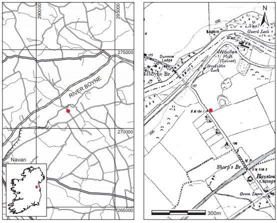
Location (Fig. 3.126)
The site was in the townland of Ardmulchan, mid-Co. Meath.228 It was approximately 30m south-east of the River Boyne, and just a short distance south-west of a ringfort229 marked on the first edition Ordnance Survey map.
Description of site
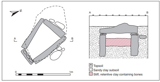
The cist was wedge-shaped in plan, with its long axis aligned north-west/south-east. Internally it measured 0.6m long by 0.44m wide by 0.25m high (Fig. 3.127). It was formed of limestone slabs, with one slab forming each of the four walls. These slabs appear to have been regular in shape, with relatively flat inner surfaces and a maximum thickness of 0.13m. The smallest of these was at the south-eastern end of the grave, measuring 0.31m long, while the opposite end stone was 0.45m long. The two side stones appear to have been similar in length, the longest being on the north-eastern side, measuring 0.75m long. A number of small stones rested on the tops of the side stones to ensure that all four walls were the same height. Packing stones had been placed outside the western end stone and the eastern side stone, and the cist was covered by a large capstone, irregular in shape, measuring 1.1m long by 0.65m at its greatest width by 0.15m in maximum thickness. The upper surface of the capstone was irregular and scored, while the underside was fairly flat and smooth. The floor of the cist was not paved with stone but consisted of sandy clay subsoil. The area around the cist had been dug away before the investigation, so it was not possible to trace the cut of the pit dug to receive the cist.
The grave contained cremated bone (2002:199), and no accompanying artefacts were found. The stratigraphy of the cist fill was as follows: an upper layer of stiff, buff-coloured clay, approximately 0.15m thick, with inclusions of comminuted bone, overlay sandy clay subsoil at the base of the cist. The pit for the cist had evidently been dug into this yellow subsoil. According to Raftery, the upper layer of clay in the cist appears to have been prepared especially for the purpose. The bones were in this layer and were almost powdered and mixed through the clay. The bones were so finely comminuted that no recognisable fragment was available for examination.
Comment
The human remains from this site have not been dated. The site is assumed to be early Bronze Age in date on the basis of its form. The cist is slightly wedge-shaped in plan but this type of variation in plan is not uncommon.
HUMAN REMAINS
E.J. KEENAN
Sample 2002:199 comprised a few small fragments of human limb and bones. Owing to the fragmented nature of the bones, it is not possible to give any data regarding age, sex, etc.
228. Parish of Ardmulchan, barony of Skreen. SMR ME025-065——. IGR 292034 271110.
229. SMR ME025-007——.