1952:012 - TONDUFF, CO. LAOIS, Laois
County: Laois
Site name: TONDUFF, CO. LAOIS
Sites and Monuments Record No.: SMR LA023-061
Licence number: E1107
Author: P.J. HARTNETT
Author/Organisation Address: —
Site type: Graves of indeterminate date
Period/Dating: —
ITM: E 643416m, N 687519m
Latitude, Longitude (decimal degrees): 52.936728, -7.354147
Introduction
In November 1952 human remains were discovered following tree-felling operations on a mound on a farm near Abbeyleix, Co. Laois. Human remains had been found years previously as a result of tree-felling but were thought at the time to be animal bones. The bones were recognised as human when a skull was discovered. The find was reported to the Garda Síochána at Abbeyleix, who visited the site and informed the coroner. The NMI was informed of the discovery after this visit, and the site was subsequently examined by P.J. Hartnett. Four graves were found in total, but all of these were very disturbed at the time of Hartnett’s visit. The first grave was in the centre of the mound, the second at the west side, and the third and fourth at the south-east. The remains were not acquired by the NMI but were reburied on site. This report is based on Hartnett’s account of the site.
Location (Fig. 6.27)
The site was in the townland of Tonduff, south Co. Laois, just over 1km north of Abbeyleix town.46 It consisted of a low, curvilinear platform or mound that sloped from north to south and rose to approximately 1m above the surrounding ground level. It is marked on the second edition OS 6in. sheet as a curvilinear area occupied by trees. The area is on high ground, 100–110m above sea level. Hartnett’s report states that a nearby field is locally called ‘the Church Field’ but there were no known traditions about this particular site.

Fig. 6.27—Locationmap, Tonduff, Co.Laois.
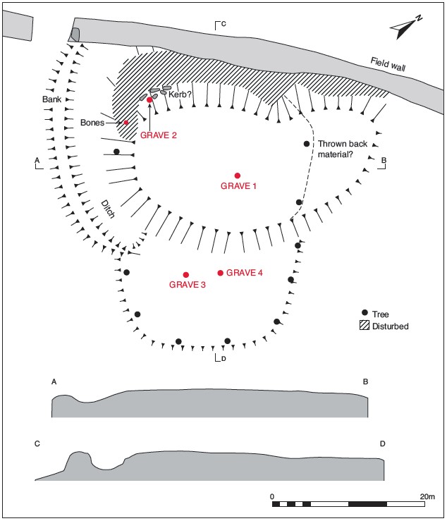
Fig. 6.28—Plan of site,Tonduff, Co. Laois.
Description of site
The mound was bounded by a field fence along its western side. Some of the material from the mound had been used in making this fence, and a considerable amount appeared to have been removed and placed to the north beyond the original edge, thus giving it an oval plan (Fig. 6.28). The original mound appears to have been roughly circular in plan, measuring approximately 28m in diameter with a D-shaped annexe at the east. At the south quadrant there was a shallow ditch, 3–4m wide (into which the edge of the platform bevelled), and a low outer bank, 3–3.5m wide at the base. This ditch and bank were interrupted at the junction of the D-shaped enclosure and were no longer traceable beyond it, possibly owing to previous disturbance.
Hartnett cut a short trial trench on the east side of the mound and found that the upper surface consisted of 0.4–0.7m of dark peaty humus. This upper layer overlay a 0.3m band of light-coloured sand, underneath which was coarse grey sand containing some large stones, which appeared to form a kerb around the edge of the raised area.47 The burials were very disturbed at the time of Hartnett’s visit, but the workers provided a description of the discovery.
Grave 1
This was located close to the centre of the mound. It lay at a depth of approximately 0.7m below the surface of the mound underneath a layer of dark peaty soil. The area was reopened by Hartnett, but only the skull and upper body were uncovered. The burial appears to have been an inhumation aligned south/north. The remains were preserved in situ.
Grave 2
This lay on the south-western slope of the mound. The grave was covered by 0.3m of peaty soil. A few large stones had been placed near the skull, which was intact when found. These stones were not visible at the time of Hartnett’s visit. The burial was an extended inhumation. The skeletal remains were well preserved but had been disturbed by the workmen. According to the finders’ account, the body lay in an extended position with the head to the north and the feet to the south.
Grave 3
This was located in the south-eastern end of the mound, in the ‘annexe’. The bones were found in what was described as a built ‘wall’. This had been removed by the finders by the time of Hartnett’s visit. From the description the ‘wall’ appeared to be a facing of stones laid flat, perhaps one side of a cist. The bones and teeth were found close to these stones. The grave contained a few bones and teeth that were in poor condition. These were reburied on site.
Grave 4
This was approximately 5m west of grave 3. In removing the stump of a tree some bone was found mixed through the roots. No further information was available about this burial.
Comment
The skeletal remains were reburied on site. In the absence of associated finds or other dating evidence these burials must be regarded as undated.
46. Parish of Abbeyleix, barony of Cullenagh. SMR LA023-061——. IGR 243475 187483.
47. Trial pits in the surrounding field gave the following stratification: 1, upper surface of dark soil as before, but extending to a depth of over 0.7m and resting directly on no. 2, grey stony sand similar to no. 3 above.