1951:017 - MANORLAND (1ST DIVISION), CASTLE STREET, TRIM, CO. MEATH, Meath
County: Meath
Site name: MANORLAND (1ST DIVISION), CASTLE STREET, TRIM, CO. MEATH
Sites and Monuments Record No.: N/A
Licence number: E1138
Author: P.J. HARTNETT
Author/Organisation Address: —
Site type: Graves of indeterminate date
Period/Dating: —
ITM: E 680103m, N 756756m
Latitude, Longitude (decimal degrees): 53.554604, -6.791088
Introduction
In October 1951 human remains were discovered by workmen engaged in laying sewerage pipes in Castle Street, Trim, Co. Meath. The remains were found at a depth of approximately 1.4m below ground level and were removed from their context upon discovery. The workers who made the discovery could not recall whether the skeletons had been articulated. The find was reported to An Garda Síochána at Trim, who informed the NMI. The site was investigated by P.J. Hartnett on 20 October 1951. This report is based on Hartnett’s account of the site.
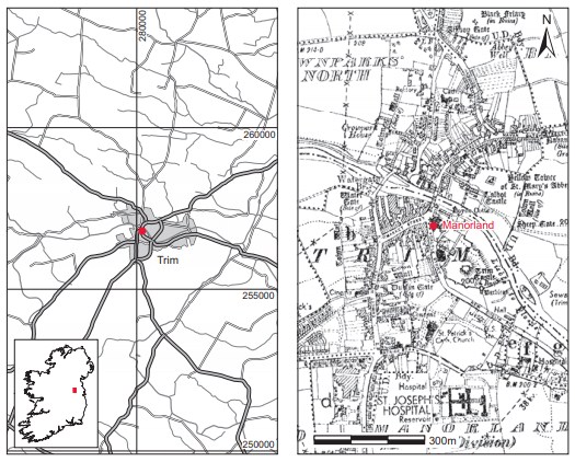
Location (Fig. 6.43)
The site was in Castle Street, Trim (td Manorland, 1st Division), Co. Meath.76 Hartnett describes the street as narrow, measuring approximately 12m wide, running southwards from the eastern end of Market Street and at right angles to it. At its southern end it skirts the western part of the curtain wall of Trim Castle. The modern courthouse, which is believed to stand on the site of an early monastic foundation, occupies the eastern side of Castle Street at its northern end. The bones were discovered close to this building, beginning at 18.3m from the junction with Market Street and traceable for 13.7m in a southerly direction along the face of the excavated trench.
Description of site
The portion of the trench where burials were found was open on Hartnett’s arrival. No grave structures were noted, but the stratigraphy of the trench was recorded. The section showed the modern street filling (sandy soil, rubble and large stones with macadamised upper surface) averaging a depth of 0.7m. Under this was darker mixed soil, fairly loose, resting on an irregular rock surface that in some places rose to within 1.3m of street level and in others dipped to a maximum of 3m. Bone was visible on both sides of the trench in this layer. Patches of lime were noted at intervals, with one almost continuous band 0.1m thick on the eastern face, at a depth of 1.3m. In the lowest burial level some fragments of charred wood, identified as oak, lay on a sandy layer at a depth of 2.1m, associated with scattered human bones. The profile of the underlying rock section suggests that stone had been quarried from here at one time and that the pit had remained open long enough to allow silt to accumulate at the bottom. The bones (2010:86) recovered by the workmen comprised three skulls and various other remains representing more than one person. The incompleteness of these remains may be accounted for by the fact that, particularly where a body lay across the narrow trench, parts of the limbs still remained in the sides of the cutting. As mentioned above, bones were noticed on either side of the trench, some just below the level of the dark soil, and at varying levels down to 2.1m. The bodies showing in section were extended parallel to the trench (north/south) with the head to the south, but it is clear that other bodies lay across the trench. No grave-goods were found.
Comment
In his report, Hartnett argues that the pre-existing pit would have afforded a convenient burying ground, and the occurrence of scatterings of quicklime may suggest rapid burial of a large number of bodies, he suggests, of plague victims or executed criminals. He discounts the argument that the burial ground could have been part of the monastic foundation on the grounds that the burials occur in a haphazard manner. He also argues that the ‘concentrations in layers in the deeper pockets of rock and tailing off towards the sides of the pit’ and the ‘sameness of the fill at all levels under modern road surface’ would negate any association with the priory. Finally, Hartnett argues that the lack of evidence for coffins or grave-slabs would indicate that this was not a formal burial ground. In the absence of any associated finds or other dating evidence this site must be regarded as undated.
76. Parish of Trim, barony of Upper Navan. ME036-048066-. IGR 280173 256805.