1950:016 - CORBALLIS, CO. DUBLIN,, Dublin
County: Dublin
Site name: CORBALLIS, CO. DUBLIN,
Sites and Monuments Record No.: SMR DU012-070
Licence number: E1058
Author: P.J. HARTNETT
Author/Organisation Address: —
Site type: Graves of indeterminate date
Period/Dating: —
ITM: E 723491m, N 747478m
Latitude, Longitude (decimal degrees): 53.462865, -6.140241
Introduction
In June 1950 a human skull was found by a lorry driver while filling sand at a quarry near Malahide, Co. Dublin. The driver removed the skull but left the remainder of the burial in situ. The site was reported to the NMI three months after its initial discovery by Miss Gwendoline Stackpoole on behalf of Dr G.F. Mitchell of Trinity College Dublin. According to this report, further bones were still visible in the section of the sandpit, about 0.61m below ground level. The site was visited on 29 August 1950 by P.J. Hartnett, who excavated the remainder of the burial that day. An area measuring 1.83m by 0.91m above the bones was opened for excavation. This revealed an extended inhumation burial with some irregular stones covering the body. This report is based on Hartnett’s drawings and report.
Location (Fig. 6.9)
The site was in the townland of Corballis in east County Dublin.14 It lay on the western side of Malahide Island, a sand bar between 0m and 15m above sea level, only 400m east of the coastline. At the time of excavation three sandpits were open along this stretch of coastline. On the first edition Ordnance Survey sheet for the area the site lies in one of only four fields marked on the sand bar. No other burials are known from this townland.
Description of site
Owing to disturbance of the site, it was not possible to distinguish the outline of the grave-pit
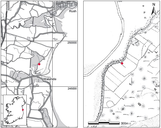
Fig. 6.9—Location map, Corballis, Co. Dublin.
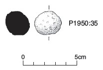
Fig. 6.10—Limestone pebble, Corballis, Co. Dublin.
in section. The grave was aligned north-west/south-east and broken ends of the humeri were visible in the section at a depth of 0.61m below ground level. Hartnett’s excavation of the area above the bones revealed the following stratigraphy. At the top of the section was a layer of fine sand (c. 1.8m thick), but this had been removed by the time of Hartnett’s visit. Directly below this was a thick layer of stony gravel. In general this deposit was mixed sand and gravel, but within 0.3m of the body numerous heavy pebbles (some up to 0.15m in greatest dimension) were encountered.15 The majority of these were water-rolled pebbles. Underneath this and resting directly on the body was a very dark deposit described by Hartnett as ‘almost peaty’ and interpreted by him as ‘decayed turves with which the body had been covered’. No structural slabs were found at the sides of the body or underneath, and the plan of the burialpit was apparently not revealed. The only measurement obtained was the length of the body (without the skull) in position, which was 1.37m.
The grave contained one inhumation burial (P1950:34) accompanied by a roughly rounded limestone pebble (P1950:35), 25mm in diameter (Fig. 6.10). The articulated body was extended on its back in a north-west/south-east direction, with the head to the northwest. The left forearm lay across the chest with the hand resting on the right shoulder, and the right arm was fully extended at the side with the hand underneath the right hip. The feet were close together, but the smaller bones had almost completely disintegrated. Except for the long bones, pelvic bones and some phalanges, the remainder of the bones (vertebrae, ribs, etc.) were in very poor condition. All the bones were blackened when removed from the sand. Underneath the skeleton was a thin layer of very fine white sand. Hartnett describes the bones as ‘small’.
A very brief report16 on the teeth suggests that the individual was twelve to sixteen years old.
Comment
In the present state of knowledge this burial cannot be dated. The limestone pebble lay at body level beside the left thigh and may have had some special significance. Hartnett compared this pebble to a granite pebble that he found possibly accompanying a crouched inhumation at Hempstown Commons, Co. Kildare (Hartnett 1950, 197).
14. Parish of Donabate, barony of Nethercross. SMR DU012-070——. 323567 247455.
15. The horizontal extent of this spread of stones is not known, but it presumably extended over the burial.
16. The report is signed ‘Dr Dockrell’. This is probably R.B. Dockrell of the Dublin Dental Hospital.