1948:005 - MURREAGH, CO. KERRY, Kerry
County: Kerry
Site name: MURREAGH, CO. KERRY
Sites and Monuments Record No.: SMR KE042-007
Licence number: E1079
Author: JOSEPH RAFTERY
Author/Organisation Address: —
Site type: Iron Age and early medieval graves, c. 300 BCc. AD 1200
Period/Dating: —
ITM: E 438330m, N 606323m
Latitude, Longitude (decimal degrees): 52.184986, -10.364367
Introduction
In September 1948 four lintel graves were discovered at Murreagh, Ballydavid, Co. Kerry. The burials had been reported to Dr R. Dudley Edwards by Revd Bernard O’Dea. The graves were discovered during the construction of a new house in Murreagh village. According to Fr O’Dea’s letter, this was not the first time that graves had been discovered here, and local lore held that they were the graves of Spanish Armada soldiers. O’Dea notes, however, that the remains of women and children were also found. The burials were reported to the NMI by Dr Dudley Edwards, and a rescue excavation was undertaken by Joseph Raftery
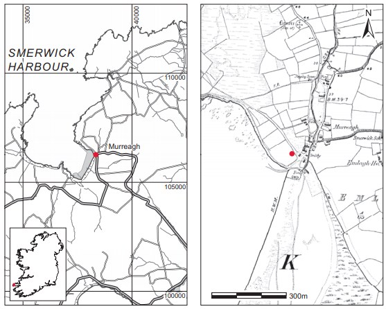
Location (Fig. 4.18)
The burials were located in the townland of Murreagh, near Ballydavid on the north side of the Dingle peninsula.39 The village of Murreagh is on the east side of Smerwick Harbour at an altitude of less than 10m above sea level. The site lies in an area rich in early medieval remains, within a few kilometres of early ecclesiastical sites such as Gallarus, Kilmalkedar and Reask.
Description of site
O’Dea describes the burials as being at a depth of approximately 1m (31 ⁄4ft) below the ground surface, in sea sand. One of the skulls is described as that of a young adult male with the upper teeth intact. The rest of the bones of this individual are described as being scattered but in
order. No artefacts were found with the burials.
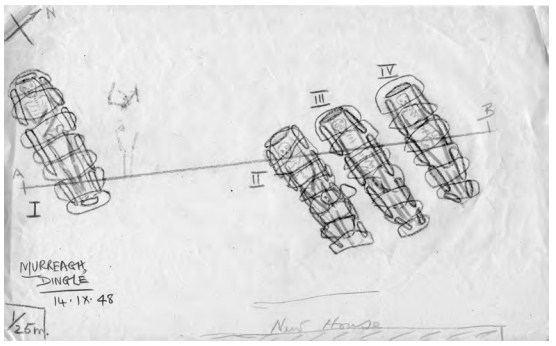
Although no report exists, the site appears to have been visited by Raftery. Dr Raftery’s sketches record four lintel graves, all aligned west/east (Fig. 4.19). Three occur in a group (graves 2, 3 and 4), while another (grave 1) lay a few metres to the south. The graves appear to have been dug into fine sand that overlay more clay-like sand. The burials were all extended with the head to the west. The burial in grave 1 had the arms bent at the elbows, with the left hand lying over the pelvis and the right hand on the ribs. The right arm of the body in grave 2 was extended, while the left was loosely flexed and placed over the right pelvis. In grave 3 the arms of the interred were extended by the sides, while in grave 4 the arms were flexed at the elbows and overlay the ribs. Raftery’s sketches indicate that all the graves were stone-lined and covered with large lintels. The graves measured on average over 2m in length and 0.75m in maximum width.
Comment
This appears to be an early medieval cemetery. Although there are a number of important ecclesiastical sites in the vicinity, it does not seem to be directly associated with a church site. It may again be compared with early medieval ancestral cemeteries that had their origins in the pre-Christian period and went out of use in the eighth or ninth century (O’Brien 2003; Stout and Stout 2008; Ó Carragáin 2009). As the report on this site came to light very recently, it was, regrettably, not possible to undertake a specialist report on the human remains or to date samples thereof.
39. Parish of Kilmalkedar, barony of Corkaguiny. SMR KE042-007——. IGR 038345 106268. Burials are mentioned in Cuppage’s survey, though no precise location is given. It is assumed that these are the burials to which Cuppage refers (Cuppage 1986, 68).