2026:149 - Ballybrittas, Wexford
County: Wexford
Site name: Ballybrittas
Sites and Monuments Record No.: NA
Licence number: 26E0385
Author: Barry Lacey (Slaneyside Heritage)
Author/Organisation Address: Corah, Ferns, Co. Wexford
Site type: Various
Period/Dating: Prehistoric (12700 BC-AD 400)
ITM: E 692556m, N 631725m
Latitude, Longitude (decimal degrees): 52.429171, -6.638991
A programme of archaeological testing was undertaken on the site of a proposed agricultural development in the townland of Ballybrittas, Co. Wexford . A geophysical survey (Nicholls; Licence No. 26R0123) was previously conducted on the site and informed the testing strategy. The results of the survey did not identify any anomalies of definite archaeological origin, nor any features indicative of settlement activity such as enclosures, pits, or ditch systems. A limited number of weak, diffuse, and poorly defined anomalies were recorded and interpreted as being of non-archaeological origin and are most likely attributable to modern agricultural practices, former field boundaries, land drainage, ferrous debris, and natural geological variation.
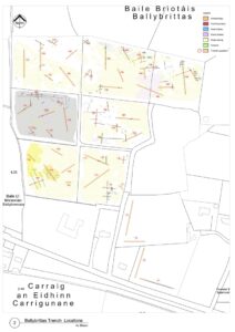
A total of 49 test trenches were excavated across the site measuring c. 1560 linear meters. The majority of these targeted geophysical anomalies to investigate their archaeological potential while others targeted open green space. Topsoil was consistent across the site comprising of a brown silty clay measuring 0.2–0.4m in depth. The natural subsoil varied across the site, mainly being a mottled orange and brown sandy clay; at the very eastern end (Trenches 1–4) an orange brown sandy clay was recorded; subsoil was recorded as a mottled light grey and orange clay with frequent small stones at the western end of the site, where the land was flat along the lower slopes.
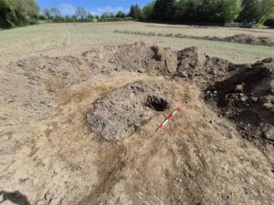
A single archaeological feature, a pit, was recorded during testing corresponding with a single circular anomaly. The pit was sub oval in plan with steep sides and a flat base measuring 2.7m x 1.5m with a recorded depth of 0.3m. It contained two fills. The upper fill was a dark brown silty clay with abundant amounts of heat-shattered stone and frequent charcoal fleck inclusions, characteristic of burnt mound material. Beneath this was a charcoal-rich soft, dark grey, silty clay. The feature was interpreted as a pit or possible trough, associated with burnt mound activity and of a probable prehistoric date.
A large number of non-archaeological features were also recorded corresponding with targeted anomalies including cultivation furrows, field and stone drains and field boundaries. Evidence of a former farmstead at the north-eastern end of the site, visible on historic mapping, was uncovered. It comprised of the partial remains of a metalled (cobbled surface) together with an abundant amount of brick, stone and post-medieval pottery within the topsoil in this area. All these features are of a post-medieval and later date and indicative of agricultural and land improvement works.