2026:164 - Middlequarter, Newcastle, Tipperary
County: Tipperary
Site name: Middlequarter, Newcastle
Sites and Monuments Record No.: NA
Licence number: 26E0023
Author: Barry Lacey
Author/Organisation Address: c/o IAC Ltd, Unit G1 Network Enterprise Park, Kilcoole, Co. Wicklow
Site type: Pits
Period/Dating: Undetermined
ITM: E 612675m, N 613560m
Latitude, Longitude (decimal degrees): 52.273582, -7.814276
A programme of test trenching was conducted to investigate the archaeological potential of a proposed development at Middlequarter, Newcastle, Co. Tipperary. A total of 9 trenches were excavated across the site measuring 260 linear metres. The location of the test trenches were designed to target the zone of notification for a church and graveyard (TS088-032001, TS088-032004), geophysical anomalies, footprint of former building, and open greenfield space, while avoiding buffer zones associated with overhead wires. Topsoil consisted of mid-brown soil which varied in depth from 0.35m to 0.9m, generally being significantly deeper in the north of the site, but was also locally deeper (0.7m in the east of Trench 2). Subsoil consisted of a yellow-grey silty clay.
The trenching strategy was informed by the results of a geophysical survey (Dowling 2025, Licence No. 25R0500), which identified several features of archaeological potential. Testing has confirmed that the site is heavily disturbed by numerous linear drainage ditches/furrows. The majority of these features extend southwest-northeast towards the River Suir to the northeast. At the southern end of the site some drains are filled with stone, but the majority are filled with silty clays. Further linear ditches/drains/furrows are evident extending northwest-southeast that are interpreted to have a similar function.
Two areas of possible archaeological potential were identified by the testing, designated as Archaeological Area 1 and 2 (AA1 and AA2). These consist of small localised possible pits. No diagnostic material was identified in the investigated sections, so their provenance is unclear, however in general they appear to pre-date the linear drainage features.
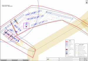
Site plan with testing results overlaying geophysical investigations