
2026:203 - Proposed Ratoath Amenity Centre, Meath
County: Meath
Site name: Proposed Ratoath Amenity Centre
Sites and Monuments Record No.: ME044-034
Licence number: 25E0945
Author: Niall Roycroft
Author/Organisation Address: c/o Meath County Council, Buvinda House, Dublin Road, Navan, Co Meath. C15 Y291.
Site type: Historic Town
Period/Dating: Modern (AD 1750-AD 2000)
ITM: E 701856m, N 752006m
Latitude, Longitude (decimal degrees): 53.508165, -6.464453
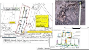
Meath County Council is proposing to develop the Ratoath Civic Centre, Amenity Park and Age-Friendly Housing on a c.1.24 ha plot of land in Ratoath Historic Town, ME044-034. All previous 19th- and 20th- century buildings on the site had been demolished above ground, apart from a boarded-up, mid-late 19th-century (but fully refurbished in the recent past) clay and stone walled cottage on the R125. The site retained three very long ‘burgage’ plot fields (gardens) with boundaries (banks with trees and shrubs). These field-gardens are all around 200-215m long x 15-20m wide.
In October 2025, the site was archaeologically tested with 985 linear metres of machine dug trial trenching 1.8m wide; around 14% of the site area.
No significant archaeological remains were found on the site. The area of greatest archaeological potential was along the R125, but this zone had been significantly disturbed in the recent past. The remainder of the site showed post-medieval ‘burgage’ (farmer) plots. While some of these plots and their ditched boundaries may have originated in the medieval period, the field system they represented is shown in good detail on the 1837 and 1909 OS mapping. All of the agricultural soils contained dispersed and broken-up animal bones, some residual medieval pottery sherds and lots of very modern pottery from the 19th – 20th century. The impression is that all soils had been thoroughly mixed in the recent past and all ditches had, until recently, been regularly thoroughly cleaned out.
Within the major ditch plots were numerous smaller furrows. All soils in these furrows contained dispersed animal bones and modern pottery.
In the fairly recent past the western plot had been used for burying whole, articulated pig carcasses (eight were found in the two trenches and more are presumed to be present). The central plot found no animal burials but their presence is a possibility. The eastern plot contained two articulated pig carcass burials. The pigs seem to have been disposed of in holes dug with a mechanical digger. Burying dead pigs ‘out the back’ was a common practice of diseased animal disposal in the recent past. In all cases the bones were confirmed to be animal. No human remains were found. Stone-filled field drains and a buried but still open, modern slurry tank were found. The burgage boundaries had been used to bury contaminated debris from the recently demolished houses.
The building at ITM: 701842, 751916 has old, probably 19th-century, external, nap rendered walls that seem to be partially built as ‘clay walls’, presumably over a stone lower section. These walls are collapsing beneath holes in the roof. But otherwise, the building has been completely refurbished, re-roofed, dry-lined and extended in the later-20th century. Most of the windows (with brick surrounds) on the north side of the house had been blocked and covered. There is a 20th-century single-oven Rayburn-type range complete with over-drying rack in the kitchen.