
2026:199 - Bakery Lane, Navan, Meath
County: Meath
Site name: Bakery Lane, Navan
Sites and Monuments Record No.: ME025-044---
Licence number: 23E0367 Ext.
Author: Niall Roycroft
Author/Organisation Address: c/o Meath County Council, Buvinda House, Dublin Road, Navan, Co Meath. C15 Y291.
Site type: Historic Town
Period/Dating: Modern (AD 1750-AD 2000)
ITM: E 686900m, N 767705m
Latitude, Longitude (decimal degrees): 53.651892, -6.685485
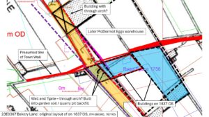
As part of the Navan 2030 Project, Bakery Lane was resurfaced and provided with additional ducting and service upgrading. Bakery Lane is c. 120m long and the project extent was around 375 sq. m. Works were completed July to November 2025.
The northernmost 70m from Trimgate Street showed no archaeological remains, as all deposits had been extensively disturbed.
The middle of Bakery Lane crosses the line of the proposed Navan Town Wall, which is identified in this area as the present boundary garden wall to the 1840s Parochial House, NIAH 14009524. No remains of any Navan Town Wall were found. Instead, there was a thick deposit of red-brown, garden-type soil with some fragments of red brick. This deposit was visible for at least 11m north-south and was over 0.7m deep, so it may have been a fill to a large (?quarry) pit. This deposit was cut by two walls that seemed to represent the remains of an L-shaped building shown on the 1837 OS. These walls were mostly retained in situ and the new services placed around them. This building seems to have been built on the line of a road outside the line of the town walls in the 1756 William’s Map.
This building shown on the 1837 OS may have had a through-arch, which included a short, curving wall perhaps for a gate. At this time Bakery Lane was 2.75m wide. When this building was demolished before 1895, Bakery Lane was widened to 4.5m. To the south of this building was a mixed, dumped deposit consisting of various tip lines and gravels. Some of these gravels may have been the mid-late 19th-century Bakery Lane surfacings. Masonry foundations to the original McDermott’s Egg warehouse (which was rebuilt again in 1970s) and the Parochial House garden wall were noted.
South of this mixed deposit was a natural gritty gravelly sand deposit that was visible for c.17m which in turn overlaid pure natural sand for the southernmost 30m. No archaeological features were noted in the southern c.47m of Bakery Lane apart from the original foundation to the Parochial House boundary wall. The exposure of sand at the southern end of Bakery Lane may reflect the mid-19th-century widescale horizontal open-cast quarrying of this area.