2026:103 - Bracetown and Gunncocks, Meath
County: Meath
Site name: Bracetown and Gunncocks
Sites and Monuments Record No.: N/A
Licence number: 26E0052
Author: Catriona Baldwin
Author/Organisation Address: Unit 5B, Block F, Nutgrove Office Park, Rathfarnham
Site type: Fulacht fia
Period/Dating: Bronze Age (2200 BC-801 BC)
ITM: E 703264m, N 743345m
Latitude, Longitude (decimal degrees): 46.488181, -15.817314
Pre-planning archaeological testing carried out in advance of a planning application for the development of a Solar Farm Underground Grid Connector north of the town of Dunboyne, Co. Meath in March and May 2026. Much of the length of the proposed underground grid connector has been previously subject to archaeological investigation including geophysical survey and testing, and, as a result, only two areas of previously undisturbed lands in the townlands of Kilrue, Gunnocks and Bracetown were proposed for this phase of testing.
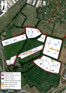
In the townlands of Bracetown and Gunnocks, 31 trenches were excavated across the two land parcels, ranging in length from 22m to 80m. In Kilrue townland, a 100m test trench was opened along the cable route adjacent to a recorded enclosure site (RMP ME045-081). In total, 32 test trenches totalling 1652 linear metres were opened across the two land parcels.
Three trenches (T1, T22 and T30) contained evidence of pyrotechnical activity, all of which corresponded with ‘speckled’ anomalies on the geophysical survey. T30 (AA2) contained a spread of burnt mound material, likely representing the remains of a fulacht fia. T1 (AA1) and T22 (AA3) produced pits containing burnt mound material. No diagnostic artefacts or animal bone were retrieved from any of these features.
The archaeological testing also revealed a series of linear features interpreted as drainage ditches (T4, T5, T9, T12, T13, T16, T17, T19, T20, T24, T26. T27, T29, T31) and agricultural furrows (T5). The majority of these features correspond with linear anomalies and ‘agricultural lines’ indicated on the geophysical survey and there was no evidence from the archaeological testing that any of these features were of archaeological significance. No dateable finds were recovered from any of the tested features, all of which were exposed at a depth of between 0.3m and 0.6m.
One sherd of medieval pottery (26E0052:1) was retrieved during the testing. The sherd was found during the excavation of a test trench (T30) and was not related to any feature within the trench. The trench (T30) contained two northwest – southeast running drainage ditches that were not considered to be of archaeological significance.