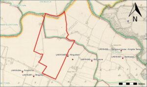
2026:333 - Braganstown & Kilsaran, Louth
County: Louth
Site name: Braganstown & Kilsaran
Sites and Monuments Record No.: n/a
Licence number: 26E0507
Author: Gill McLoughlin
Author/Organisation Address: c/o Courtney Deery Heritage Consultancy, Unit 5B, Block F, Nutgrove Office Park, Rathfarnham, Dublin 14
Site type: Burnt mound spread
Period/Dating: Prehistoric (12700 BC-AD 400)
ITM: E 703834m, N 794926m
Latitude, Longitude (decimal degrees): 53.893329, -6.420270
Pre-planning archaeological testing was carried out on land under consideration for a solar farm development, in the townlands of Braganstown and Kilsaran, Co. Louth. The site is bounded by the River Glyde to the north and is located 1.5km west of the town of Castlebellingham, and 7.7km northeast of the town of Ardee.
The testing followed a geophysical survey and was primarily proposed to investigate the geophysical survey results, with a view to excluding definite archaeological sites from the future planning application, as well as targeting areas of more significant ground disturbance works related to access roads, compounds and transformer locations.
The results of the testing will inform the final design layout and be included in an Archaeological Impact Assessment (AIA) which will be submitted with the planning application.
The testing took place over ten days from 6–17 July 2026 and 58 trenches across seven fields, totalling 2230 linear metres, were excavated.
Archaeological material was identified in one trench – T6 in field 2, which targeted a speckled geophysical anomaly and proved to be spreads of burnt mound material and a possible associated trough. The main burnt mound deposit (C23) extended for 3m east-west within the trench and extended beyond the trench to the north and south, with the geophysical survey indicating an overall extent for the deposit of 21m north-south by 10m (centre point: 703675E, 795084N).
Speckled geophysical anomalies were also tested in T20, T40, T44, T46 and T48 and there was nothing visible in T20, T44 or T46 which would account for the anomalies. In T40 the anomaly was related to modern debris and in T48 the anomaly could possibly be attributed to a change in the natural subsoil. Based on a combination of the speckled anomaly in T6 proving to be a burnt mound spread, the proximity to similar features, topographical and geophysical considerations, a further four areas containing speckled geophysical anomalies which were not tested, are deemed to be of archaeological potential, possibly also representing burnt mound sites.
Elsewhere, the features encountered in the test trenches, although they do for the most part reflect the geophysical survey results, do not represent features of archaeological significance. In some cases the features were clearly modern-type drains, particularly in the lower-lying Fields 1, 3 and 4. In other cases the interpretation of linear features identified is based on a combination of their frequency and similarity across the test area, alignment with existing boundaries as well as the nature of their fills and associations with other features. In Fields 5, 6 and 7 the soils were generally more gravelly and as a result better drained, so where present, these linear features may represent divisions within a former field system. The only dateable finds recovered from any of these features were modern.