2026:183 - Kildare Innovation Campus (KIC), Barnhall Road, Parsonstown, Leixlip, Kildare
County: Kildare
Site name: Kildare Innovation Campus (KIC), Barnhall Road, Parsonstown, Leixlip
Sites and Monuments Record No.: N/A
Licence number: 24E0535 ext.
Author: Michael Greiner & Seán Shanahan; Shanarc Archaeology Ltd.
Author/Organisation Address: Unit 39a, Hebron Business Park, Hebron Road, Kilkenny
Site type: No archaeology found
Period/Dating: N/A
ITM: E 699001m, N 734542m
Latitude, Longitude (decimal degrees): 53.351818, -6.512964
Archaeological test-excavations were carried out between 19 and 21 May 2026, in relation to Phase 2 of a multi-phase development of the Kildare Innovation Centre at the Kildare Innovation Campus (KIC), also known as Liffey Business Campus, occupying the former Hewlett-Packard (HP) site at Barnhall Road, Leixlip, Co. Kildare.
For results from the earlier Phase 1 area which was previously tested under the initial grant of the same excavation licence, please see separate excavation bulletin entry (2026:076).
Prior to testing, the greenfield areas of the wider site were subjected to a geophysical survey, under survey licence no. 24R0033; five of the associated geophysical survey areas fell within the Phase 2 development area. The geophysical survey data was primarily indicative of extensive modern disturbance, though a small number of anomalies were identified as potential archaeology in the form of possible pits or deposits.
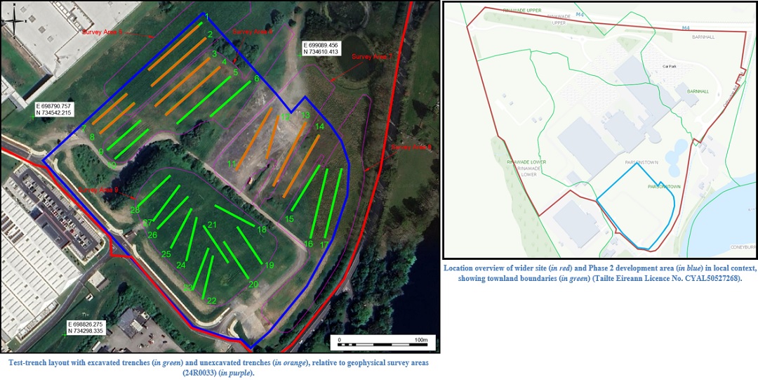
The initial testing proposal had been for the excavation of twenty-eight test-trenches; however, only eighteen test-trenches and one test-pit were ultimately excavated. Excavations in Trench 1 showed the ground in this area of the site to comprise at least 2.5m depth of made ground; this area of the site had been previously stripped to subsoil levels during the initial development of the site around 1995, and was subsequently built up and landscaped, with imported material and/or topsoil from other parts of the site. Ultimately the excavation of Trench 1 simply comprised the excavation of a test-pit at the northern end of the trench, to investigate the depth of the made ground. The made ground was found to have a depth of at least 2.5m, with water encountered at c. 2.5m preventing any deeper excavation. As the ground in this area was shown to comprise made ground, with a depth that made testing to natural levels unfeasible, the remainder of Trench 1, and the surrounding Trenches 2, 3, 4, 7 & 8 were not excavated.
Trenches 11, 12, 13 & 14, were located in a parking/storage area of the site comprising a compacted gravel/hardcore area; as the area was in use, the relevant test-trenches were not excavated.
The eighteen excavated test-trenches were 2m in width, and with the exception of the test-pit (Trench 1) which was c. 4m long and c. 2.5m deep, the test-trenches varied in length from 50–80m, and had maximum depths ranging from c. 0.5–1.2m.
With occasional exceptions, the general stratigraphy of the excavated material in the test-trenches comprised c. 0.12m of sod overlying c. 0.3m of moderately compact, light-brown sandy silty topsoil, with a moderate amount of small sub-rounded stones. The underlying natural subsoil comprised a compact, dark-brown silty sand with a moderate amount of small and medium sized sub-rounded stones.
There was frequent evidence of modern linear features, primarily in the form of field drains, as well as occasional modern pits, and frequent evidence of previous modern construction activity comprising various areas of gravel deposits and backfilled construction waste.
No archaeological finds, features, or deposits were identified in any of the excavated test-trenches.