2026:104 - Kilgobbin (Clay Farm), Dublin
County: Dublin
Site name: Kilgobbin (Clay Farm)
Sites and Monuments Record No.: n/a
Licence number: 18E0740 ext
Author: Gill McLoughlin
Author/Organisation Address: c/o Courtney Deery Heritage Consultancy, Unit 5B, Block F, Nutgrove Office Park, Rathfarnham, Dublin 14
Site type: Bronze Age pits and post-holes, early medieval pit
Period/Dating: Multi-period
ITM: E 719894m, N 724236m
Latitude, Longitude (decimal degrees): 53.254922, -6.203189
Archaeological monitoring of ground disturbance works within the Clay Farm Phase 2 development area commenced in January 2019 and has continued on a phased basis through 2020, 2021, 2022, 2023, 2024, 2025 and was completed in January of 2026.
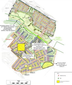
The archaeological excavation of Area 2, which was identified during testing in 2014, took place in March – April 2019 and focused on three areas; 2A, 2B and 2C. Area 2A comprised a cluster of pits and post-holes and finds included middle-late Bronze Age pottery and fragments of quern rubbing stones as well as charred cereals and charcoal. Area 2B comprised a single pit and Area 2C comprised three features of uncertain date and function. Radiocarbon dating of a sample of charred spelt wheat from one of the pits in Area 2A returned a date range in the late Bronze Age (cal BC 1264-1056).
Monitoring of groundworks in 2020 and 2021 resulted in the excavation of an additional two small areas (Area 5 and Area 6).
Area 5 presented as a scatter of pits. The focus of this area was a sub-rectangular pit containing a layer of charcoal and evidence of in-situ burning. A small number of finds (prehistoric pottery and flint) were recovered from some of the pits which were random in layout. The flint and pottery indicate settlement, however the features identified did not point to a structure in this location. Analysis of pottery sherds from Site 5, which were very small and fragmentary, suggested a date in the Chalcolithic period (c.2450-2200BC) and radiocarbon dating of a sample of oak charcoal from the fill of one of the pits returned a slightly later date range of cal BC 2025-1827.
A sample of hazel charcoal from the basal fill of the rectangular pit in Area 5 yielded a radiocarbon date range of cal AD 1046-1218, placing this pit in the beginning of the later medieval period, and not associated with the Early Bronze Age features in Area 5.
Area 6 comprised a large pit containing a deposit of stones which appears to have been related to land clearance or drainage or both.
A ditched enclosure identified during the testing in 2014 and referred to as Area 3 (ITM 720106E, 724063N) was fenced and preserved in situ in a green space within the development. An initial animal bone sample from the ditch submitted for radiocarbon dating failed, but a second sample, of hazel charcoal yielded an early Medieval date (cal AD 892-992).