2025:282 - MAGHERNAKELLY, Drum, Monaghan
County: Monaghan
Site name: MAGHERNAKELLY, Drum
Sites and Monuments Record No.: N/A
Licence number: 24E1224
Author: Liam Coen c/o Courtney Deery Heritage Consultancy
Author/Organisation Address: Nutgrove Office Park, Rathfarnham, Dublin 14
Site type: Burnt mound
Period/Dating: Prehistoric (12700 BC-AD 400)
ITM: E 658940m, N 818430m
Latitude, Longitude (decimal degrees): 54.111552, -7.098607
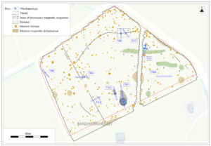
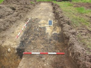
Test excavations in advance of a planning application took place as part of an assessment for a greenfield site in Maghernakelly, Drum, Co. Monaghan. Nine trenches were excavated to investigate the results of a geophysical survey (Leigh 2024; licence no. 24R0379) that indicated several features that may be of archaeological significance. Test excavations revealed only a single area of archaeological interest, AA1, that comprised of a burnt mound deposit filling and overlying a pit or trough. The feature was truncated by a former field boundary visible on early OS maps. Burnt mounds, sometimes known as fulachtaí fia, are relatively common prehistoric archaeological sites using heated stone for heating/boiling water for one or a variety of domestic, social or ritual purposes. The remaining geophysical features investigated comprised of former field boundaries and scattered evidence of brick making.
Reference
Leigh, J. 2024 ‘Geophysical Survey Report. Maghernakelly Townland, Drum, Cootehill, County Monaghan. Licence Number: 24R0379’. Unpublished report prepared by J. M. Leigh Surveys on behalf of Courtney Deery Heritage Consultancy Ltd.