2025:317 - BENNETTSTOWN AND DUNBOYNE, Meath
County: Meath
Site name: BENNETTSTOWN AND DUNBOYNE
Sites and Monuments Record No.: N/A
Licence number: 25E0056
Author: Barry Lacey, c/o IAC Ltd.
Author/Organisation Address: Unit G1 Network Enterprise Park, Kilcoole, Co. Wicklow
Site type: Ringfort - rath and Ring-ditch
Period/Dating: Multi-period
ITM: E 701566m, N 743558m
Latitude, Longitude (decimal degrees): 53.432328, -6.471552
Archaeological testing was undertaken on the site following geophysical investigations (Licence No. 23R0292). Test trenches targeted geophysical anomalies and open green space. A total of 24 trenches were mechanically excavated across the test area measuring 1398m linear metres in total.
Archaeological testing uncovered two areas of archaeological significance, named AA1 and AA2.
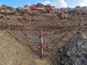
AA1 contained a large enclosure defined by a steep-sided ditch ranging in width from 1.8–2.2m with a recorded depth of 0.84–1m. It had an internal diameter of between c.38–42m with a break in its south-east section visible on geophysics, possibly representing an entrance. A second break is visible in the south-west portion of the enclosure but the function of this is less clear. A recut of the enclosure ditch was recorded in section. The enclosure is likely to represent an early medieval ringfort with its internal diameter being within the normal range of such monuments. Additionally, a majority of ringforts have south-east facing entrances.
AA2 contained a small circular enclosure defined by a ditch with a recorded width of 2.3m wide by 0.7m deep an an internal diameter of c. 3m. A recut of the ditch was recorded in section. The enclosure is likely to represent a Bronze Age or Iron Age ring ditch. A shallow ditch was also recorded in AA2 located c. 8m to the north of the enclosure. It contained a single silty sand fill with its function or date unknown.
A section of the former townland boundary separating Dunboyne and Bennetstown townlands was recorded during testing with gently sloping sides and a concave base. Numerous field drains were recorded within trenches across the site, particularly along the flat western and central areas and represent land improvement works. Agricultural plough furrows recorded in Trenches 1 and 2 represent past agricultural activity.