2025:488 - Phase 2 Monitoring, Educate Together Secondary School, Feltrim Road, Drinan, Swords, Dublin
County: Dublin
Site name: Phase 2 Monitoring, Educate Together Secondary School, Feltrim Road, Drinan, Swords
Sites and Monuments Record No.: N/A
Licence number: 25E0601
Author: Alva Mac Gowan / Archaeology Plan
Author/Organisation Address: 129 North Strand Road, Dublin 3 D03 W8C1
Site type: Kiln pit
Period/Dating: Undetermined
ITM: E 719667m, N 745693m
Latitude, Longitude (decimal degrees): 53.447711, -6.198479
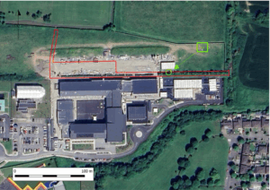
Monitoring took place of groundworks relating to phase 2 of the Malahide Portmarnock Educate Together Secondary School located on Feltrim Road in the townland of Drinan, Swords, Co. Dublin.
Phase 2 monitoring took place in July 2025, this phase covered the ball courts to the north of the main block, groundworks included an attenuation tank below the ball courts and associated drainage. A linear pipe trench running east-west from the ball courts to the eastern site boundary revealed a single archaeological feature (C4). After consultation with the National Monuments Service it was agreed the feature should be excavated and preserved by record.
Upon excavation, the feature revealed was oval in plan (1.7m x 0.83m x 0.14m) with gently sloping sides and a relatively flat base that sloped slightly to the southeast. The feature appeared to be the base of a kiln pit that had been truncated by modern agricultural activity. The pit contained three fills, the most recent fill appeared to contain a lot of charcoal and was sampled for C-14 and environmental analysis. Preliminary interpretation suggests the feature dates to the later medieval period due to the presence of a sherd of Dublin-Type fine ware (late 13th-14th century). However, this is yet to be confirmed after C14-dates are returned. Initial inspection of the environmental sample revealed a large amount (100+) of charred cereal grains.
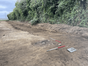
Pre-ex shot of kiln pit viewed from northwest in relation to east-west field boundary.C-14 dates and results of environmental report to be added in due course.