2025:751 - Bishop Lucey Park, Cork
County: Cork
Site name: Bishop Lucey Park
Sites and Monuments Record No.: CO074-034002-
Licence number: C001094 / E005387
Author: David Murphy
Author/Organisation Address: 3a Westpoint Trade Centre, Link Road, Ballincollig, Cork
Site type: Urban - town defences
Period/Dating: Late Medieval (AD 1100-AD 1599)
ITM: E 567235m, N 571780m
Latitude, Longitude (decimal degrees): 51.897211, -8.476079
Archaeological monitoring of the Bishop Lucey Park Regeneration Scheme in Cork city centre was carried out between July 2024 and November 2025. The vast majority of the work requiring monitoring was completed between July 2024 and May 2025. The monitoring programme and associated limited archaeological excavation, was carried out under an extension to Ministerial Consent C001094 (Activity No. E005387) issued by the Minister for Housing, Local Government and Heritage under Section 14 of the National Monuments Act (1930-2004) in June 2024.
The monitored works included ground reductions around the medieval city wall (CO074-034002-) and the area of the new pavilion at the eastern end of the site, the area of the new tower feature at the western end of the site, along the route of retaining walls associated with construction of the central plinth feature and along the routes of newly-installed services. The monitoring programme also included the supervision of conservation works to the section of the city wall which has been presented within the park as part of the scheme.
Aside from the city wall itself, no archaeological remains which could be proven to predate the post-medieval period were encountered during the project. The vast majority of the substrata impacted during groundworks were heavily disturbed and/or modern in nature. In general, the depth at which undisturbed deposits survived within the park was between 1.6m and 1.7m below the surface level of the park prior to the outset of the regeneration project.
Wall foundations were frequently revealed during the groundworks, however, the vast majority of these appeared to represent the remains of the late 18th– or 19th-century structures which were demolished ahead of the development of Bishop Lucey Park in the mid-1980s. The foundations corresponded to the layout of those depicted on the Goad Insurance maps and those recorded during preceding archaeological excavations within the park. One fragmentary wall foundation revealed to the west of the city wall and north of the Masonic Lodge building likely dated to the late-17th or early 18th century based on the ceramic assemblage recovered from a surrounding intact clay deposit. The wall may relate to post-medieval property divisions extending northwards from the Tuckey Street frontage.
Three separate deposits of heavily disturbed, disarticulated human skeletal remains were uncovered during the monitoring programme. Two of these deposits were located inside the line of the city wall, adjacent to Christchurch graveyard, while the third deposit was located outside (east) of the southern portion of the city wall. These deposits have been interpreted as disturbed ‘charnel pits’ which were originally associated with the clearance of graves from within Christ Church graveyard. It is probable that some of this bone had been moved on more than one occasion. Only the uppermost portions of the pits located adjacent to Christchurch graveyard were excavated, with a significant amount of the disarticulated remains being left in situ.
The osteological analysis completed as part of the project reveals that a combined total of 10,329 individual bone fragments and 12 loose human tooth fragments were recovered from the three revealed burial locations and from this assemblage a minimum number of individuals (MNI) of 35 adult individuals and 15 non-adults (including 1 neonate) could be determined. The presence of juveniles, a neonate, along with the absence of any bone markers indicating weapon strikes or injuries, would appear to discount any connection between the retrieved bone assemblage and the folkloric accounts of the presence of mass burial pits associated with events such as the Battle of Knocknanuss (1647) and the Siege of Cork (1690) within the park.
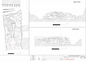
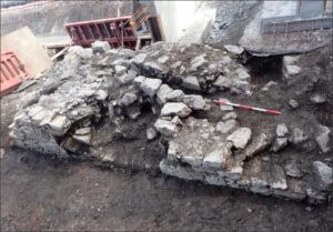
With regards to the city wall itself, the vast majority of the extent of the wall that was revealed during the subject works had previously been revealed and recorded during the 1984 and 2022 excavations undertaken within the park. At its southernmost end, following the removal of concrete slab and overburden, an additional 2m of wall top was revealed during the works beyond what had been revealed during the 2022 excavation. However, this portion of the wall was heavily disturbed by piling undertaken in the 1980s and had been truncated below the level of Drain 1. The wall remained of random rubble construction (largely limestone), roughly coursed and corresponded to the late 12th/early 13th-century phase of construction. A programme of digital recording of the City Wall was carried out to supplement the previous hand-drawn records.