2025:477 - CORK: Beamish and Crawford, South Main Street, Cork
County: Cork
Site name: CORK: Beamish and Crawford, South Main Street
Sites and Monuments Record No.: CO074-034001
Licence number: E005694
Author: Bruce Sutton of Rubicon Archaeology Ltd.
Author/Organisation Address: The Glen Distillery Business Park, Old Whitechurch Road, Kilnap, Cork, T23 HY01
Site type: Excavation - miscellaneous
Period/Dating: Medieval (AD 400-AD 1600)
ITM: E 567090m, N 571599m
Latitude, Longitude (decimal degrees): 51.895576, -8.478168
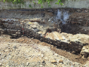
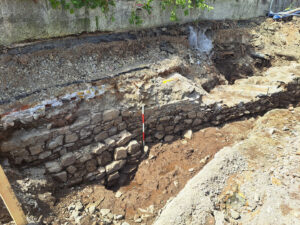
Previous test-trench works identified strong evidence of a previously unrecorded length of the the Cork City Defences. The top of this is at approximately 1.85mOD. Monitoring during construction included mitigation to preserve this wall in situ. All construction work was completed under archaeological supervision. It is evident from its location and form that the identified length of wall represents a surviving element of medieval city wall, and post-medieval rebuild.
Excavation to the base of the existing city wall was undertaken as part of earlier test-trenching (see https://excavations.ie/report/2024/Cork/0034905/), with little additional excavation of undisturbed sub-surface deposits undertaken at construction stage. Pile locations were agreed with the National Monuments Service and 750mm diameter tubes installed at pile locations. Sandbags were then placed around the city wall and the area backfilled to formation level. Piling mats were placed over the ground to ensure that weight was evenly distributed across the area during the piling process, which resulted in concrete piles being excavated to required depths.
Removal of the modern quay wall was excavated to the proposed level and had no impact on the underlying city wall.
All works were undertaken under archaeological supervision. No additional archaeological features or deposits were identified during monitoring, with material C006 appearing to be infill material to raise ground level to its current height. The majority of material excavated had been removed during the earlier test-trenching phase, in Test-pits 1–3, with additional excavation being limited in nature. With the linking up of test-pits the upper element of town wall was traced to the east of that identified previously. This had been previously identified in Test-pit 2.
There are four elements to the identified wall (C005, C007, C008 and C009):
C005 is the surviving element of stone wall with a height of 0.54m, with its top at 1.85 MOD. It is aligned with the existing quay wall, orientated west-north-west/east-south-east. A 1.85m-section of this was recorded, sitting over footing C007. It comprises 3–4 uneven courses of roughly hewn limestone faced to present a flat internal face. Stones are bonded with a soft pink-grey mortar with sandstone inclusions. Width was not directly measurable as it underlies the modern quay wall, but is estimated to be approximately 1m wide. Wall C005 was recorded for 5.4m to the east, but only the top element was visible. It continued outside the excavation area. At its western end it is broken, continuing as C008 (see below). The soft pink-grey mortar would suggest that wall C005 is a section of surviving medieval wall.
C007 is a wider area of stone underlying C005. It was recorded for a height of 0.9m (0.5mOD), which appears to be to the base. Stone is roughly hewn uncoursed limestone, not faced and unbonded. C007 steps out 0.35m from wall C005, giving an approximate width of 1.35 m.
C008 connects to the western end of wall C005. The wall changes alignment, continuing to the north-west, rather than west-north-west/east-south-east. This section of wall was 5.3m long, 0.95m high and 0.7m wide, where exposed. C008 comprised roughly-hewn limestone, with occasional sandstone, in uneven courses and bonded with a firm grey mortar. Small brick fragments within the fabric, combined with the firm grey mortar, indicate a post-medieval date for this section of wall. Stones on the external, riverside, face were faced to a higher standard to those on the inner face. C008 terminates near to the north-west edge of excavation at the junction with wall C009.
C009 is a small fragment of wall visible at the north-west edge of excavation, with only 0.2m length within the excavation area. It was 0.7m high and 0.55m wide, comprised of undressed roughly hewn limestone, seemingly uncoursed with a light grey lime mortar. Unfortunately, not enough was located within the excavation to clearly determine its function, orientation or date.