2025:181 - Ballytigeen, Cork
County: Cork
Site name: Ballytigeen
Sites and Monuments Record No.: CO100-005
Licence number: 25E0475
Author: Gill McLoughlin
Author/Organisation Address: c/o Courtney Deery Heritage Consultancy, Unit 5B, Block F, Nutgrove Office Park, Rathfarnham, Dublin 14
Site type: Burnt mounds & ringfort
Period/Dating: Bronze Age (2200 BC-801 BC)
ITM: E 583860m, N 562190m
Latitude, Longitude (decimal degrees): 51.811735, -8.234072
Pre-planning archaeological test trenching was carried out in response to a Request for Further Information (RFI) relating to a planning application for the importation of soil and stone to raise the level in an agricultural field and the construction of an associated temporary haul road.
The greenfield site is in Ballytigeen townland, on the east side of Cork Harbour and approximately 1km south of Whitegate, 1km north of Trabolgan holiday village and 650m southeast of Whitegate oil refinery. The site is bounded to the west by local road L3646.
The RFI (No. 3 – Archaeology) required that geophysical survey and archaeological testing be carried out under licence to the National Monuments Service (NMS). Geophysical survey was carried out in March-April 2025 and the archaeological testing took place over five days from 23 June 2025.
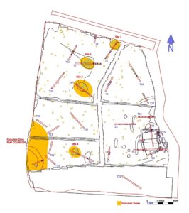
A Ringfort (CO100-005) is located outside of the redline boundary but within the land ownership boundary and a redundant record (CO100-041) is located in the east of the development area. The redundant record was listed as a ‘potential site – cartographic’ in the SMR (1988) but was deemed to be a natural feature based on a site visit in 1991.
Four sites comprising burnt mound activity were identified through archaeological testing in Trenches T1, T2, T4 and T6 (Sites 1-4) and corresponded very closely with the geophysical survey results. The sites were very close to the surface, beneath as little as 0.1–0.15m of topsoil.
Ringfort CO100-005 presents as a semi-circular raised area and gentle scarp and a very shallow ditch or depression, and an irregular spread located at the base of the scarp in Trench T14 may be ploughed-out remains associated with it.
The possible rectilinear enclosure indicated in the geophysical survey in the east of the proposed development area was thoroughly tested, and while features were identified corresponding with the geophysical anomalies, collectively they do not provide evidence for an enclosure.
The location of redundant record CO100-041 was specifically targeted with Trench T15 but it is likely that the potential site referred to in the original Sites and Monuments Record (SMR) actually refers to the raised rocky outcrop immediately southeast which has been targeted with Trenches T8, T9, T22, T22 and T24. There is no evidence for an archaeological site in this location and the site is confirmed as a
redundant record.