2024:716 - SEASONPARK, Newtownmountkenndy, Wicklow
County: Wicklow
Site name: SEASONPARK, Newtownmountkenndy
Sites and Monuments Record No.: N/A
Licence number: 23E1009
Author: Alva Mac Gowan, Archaeological Management Solutions (AMS)
Author/Organisation Address: Fahy’s Road, Kilrush, Co. Clare. V15 C780
Site type: Burnt mound
Period/Dating: Undetermined
ITM: E 726350m, N 706420m
Latitude, Longitude (decimal degrees): 53.093397, -6.113527
A program of archaeological monitoring and subsequent excavation was undertaken in response to a planning condition in advance of the construction of 57 residential units and associated development works at 108 Church Hill, Newtownmountkennedy, Co. Wicklow. The site consisted of 1.57 hectares of greenfield land within two pasture fields located at the northwest of Newtownmountkennedy village, within the townland of Seasonpark, just north of the northern banks of the Altidore River. The topography of the site gently slopes to the southeast, and a natural spring is situated on the upper part of this slope to the western end.
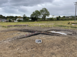
Archaeological monitoring was carried out between 10–17 November 2023. The remains of a burnt mound was discovered during monitoring in the north-west corner of the site, on the upper part of a gentle slope. This was fenced off while approval for excavation was sought. No other archaeology was found during monitoring.
Excavation of the burnt mound took place from 26 August–6 September 2024. The excavation revealed most of the feature had been truncated; what remained was just c.0.25m deep. This material was composed of two deposits, which overlay a shallow trough. These layers of the burnt mound were further disturbed by field drains, a relic field boundary, a natural depression and a relatively recent field soak.
The burnt mound material measured 9.3m north–south by 8.1m with a depth of c.0.25m. Two deposits were recorded—the main burnt mound deposit, C.5, and a second deposit, C.6. C.5 comprised a rooty dark black silty clay, with inclusions of c.70% small heat-affected stone measuring, on average, 60mm x 40mm x 30mm in size. The heat-affected stone was mainly red sandstone. The second deposit (C.6) which was found on the northern edge of the burnt spread contained less charcoal-rich silty clay, but a higher concentration of the red heat-shattered stones, it was overlayed by the burnt spread (C.5). Situated on a slight slope, this stonier deposit (C.6) could have been the result of hill wash.
A possible trough (C.7) was recorded slightly southwest of the mound’s centre. It was difficult to ascertain the original dimensions of this possible trough feature due to modern disturbance. A sample was retrieved from the lower context (C.12) for C14 dating. In appearance it was practically identical to material recovered from the burnt mound spread so it could also have been backfilled from the mound material itself. Since any upper fills in the trough were disturbed by later agricultural drains, the main focus was retrieving what was still intact (i.e., the lower section). From the mound’s surface to the base of the trough, it measured between 0.43m and 0.5m deep. The base of the trough feature measured 1.06m in length (east–west) and 0.85m in width; it was relatively flat with a rounded break of slope on its western side and straighter break of slope on its eastern side. The southern side was stepped; whether this was part of the original feature, or as a result of later disturbance, it was difficult to tell.
No archaeological objects were retrieved during the investigations. Charcoal samples from the trough feature and layers of the burnt mound have been submitted for C14 dating; until these return the date of the feature remains unknown.
On a side note and in relation to the more recent past of the site, it is worth noting that during the archaeological investigations, some informal conversations took place with two local residents, who were curious about the archaeology and keen to share their own knowledge and connection to the site in question. The first resident lives nearby and the site at Seasonpark formerly belonged to his family for at least three generations. His late grandfather, who died in 1950, would have been the last person to work the land, after which it was leased for grazing and remained unchanged.
According to the local resident, the land was used to graze cattle, sheep and horses. The ruins of a hut-type building were noted during monitoring, and the resident relayed that the building was once a cottage his grandfather leased to an elderly woman. The house was left vacant and fell into disrepair after she left in the 1940s when her tenancy was terminated due to the introduction of land taxes. His late grandfather, who was a joiner, also had a sawmill on the site where he worked alongside his brother. The mill was reportedly located to the right of what is now the site entrance; however, it did not turn up during topsoil stripping nor is it visible on the 25-inch Ordnance Survey (OS) map (1888–1913) indicating it dated to the twentieth century and could have been a more temporary in nature. According to the resident, the remainder of the east-facing wall of the sawmill is now the boundary wall that faces east onto Church Street. The sawmill was unusual in that the saw was driven by a tractor. The local resident remembers the mill during his lifetime, which means it continued in use after 1950. His grandfather also had a joinery workshop in the village. A second local resident relayed the joinery workshop connected with the sawmill was originally located on his premises, on the Main Street. He added that coffins were produced there; this knowledge was gleamed from the property deeds.