2024:904 - Strand Hill (Phase 1), Crobally Upper, Waterford
County: Waterford
Site name: Strand Hill (Phase 1), Crobally Upper
Sites and Monuments Record No.: WA026094---- (enclosure); WA026095---- (pit burial); WA026096---- (pit burial);
Licence number: 24E0081
Author: Jose Manuel Salinas & Paul Stevens/Archaeological Management Solutions Ltd
Author/Organisation Address: 19 High Street, Kilkenny
Site type: Bronze Age funerary activity/early medieval ringfort & souterrain
Period/Dating: Multi-period
ITM: E 658450m, N 602397m
Latitude, Longitude (decimal degrees): 52.170294, -7.145520
Excavation in the northeast of Tramore town took place in advance of a larger residential development at Strand Hill, and followed on from a geophysical survey (JM Leigh, Licence: 20R0045), archaeological testing (F. Coyne; Licence: 20E0596), archaeological monitoring of topsoil stripping (G. Fegan 2022; Licence: 22E0266) and partial excavation of a Bronze Age flat cremation cemetery (G. Fegan 2023; Licence: 22E0266 ext.). This phase of works comprised archaeological excavation of two discrete sites: a northern area (Bronze Age flat cremation cemetery – SMR: WA026-095/96) and a southern area (early medieval rath-ringfort and souterrain – SMR: WA026-095).
Bronze Age Flat Cremation Cemetery: Work in the northernmost area continued on from and concluded Grace Fegan’s 2023 excavations (Licence: 22E0266 ext.), which recorded twenty-one cremation pits, two funerary Urn burial pits and other associated features related to a Bronze Age phase of occupation. Several possibly associated isolated features, left unresolved by the previous excavation, were fully investigated in the current excavations; these included three pits, two post-holes, a stake-hole and four burnt in-situ spreads (including two possible pyres). One sherd of prehistoric pottery was recovered from a pit.
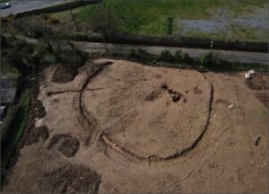
Early medieval Rath-ringfort and Souterrain: The southern site represented a circular enclosure with several internal and external associated features together with a pre-ditch drainage feature along the southern lower half of the enclosure. The enclosure ditch was penannular, with east-facing entrance and an internal diameter of 31.2m (north–south), defined by a single ditch ranging from 1.1–2.9m in width and 0.32–0.96m in depth. Approximately 70% was excavated, with the remainder truncated by the roadway to the southwest and outside the current development. Finds retrieved from the ditch fills included a stone hammer and a hone stone, plus a localised deposit of shell (clam) and very occasional animal bone and teeth that survived in small fragments.
The interior was dominated by a souterrain, comprising three chambers of increasing size ranging up to a maximum of 2.6m in dimeter, plus several small pits, stake-holes, a small kiln/hearth, a spread and a scorched soil surface. The souterrain consisted of a burnt spread sealing a small stone-lined access chamber, linked by a narrow hole to a stepped corridor that led down into a deep, circular and U-shaped rock-cut chamber. The entire structure was oriented north–south and has a total length of 7.95m.
Finds recovered from the enclosure area included a copper alloy ring pin, spindle whorl, multiple partial quern stones, iron loop, iron object and a black decorated glass bead are all indicative of early medieval date.
There was some limited evidence of undated activity post-dating the abandonment of the enclosure, consisting of three later features that included a large pit, a smaller pit and deposit of burning material.