
2024:877 - Navan 2030 Project: Old Cornmarket, Fair Green, Bedford Place, Church Hill, Navan, Meath
County: Meath
Site name: Navan 2030 Project: Old Cornmarket, Fair Green, Bedford Place, Church Hill, Navan
Sites and Monuments Record No.: ME025-044---
Licence number: 23E0367 Ext.
Author: Niall Roycroft
Author/Organisation Address: c/o Meath County Council, Buvinda House, Dublin Road, Navan, Co Meath. C15 Y291.
Site type: Historic Town
Period/Dating: Modern (AD 1750-AD 2000)
ITM: E 686968m, N 767661m
Latitude, Longitude (decimal degrees): 53.651485, -6.684469

The 23E0367 Ext. 2024-2025 works covered an area of around 0.8 hectares of Navan Historic Town, ME025-044.
- Area 1 Old Cornmarket
Limited remains due to extensive truncation from previous lane refurbishment works of the 1990s + many services. The northern area revealed truncated natural sands and some encroachment into the Old Cornmarket area seen by two patches of industrial work floors associated with scorched areas that may have been associated with smithies. Also found were several medium-sized, post-medieval pits (as seen by pottery) that might have been for opportunistic sand quarrying in the open market space. These features were thought to belong to buildings shown on the 1837 OS map which were swept away in a wholesale refurbishment of the area in the mid-19th century. Stone box drains and soakaways were seen to be associated with this mid-late 19th-century phase. Deeper works in the middle and southern parts of Old Cornmarket were limited to the eastern side of the lane and just showed the backfilled construction cut and foundations of Boyne House (1896) and its boundary wall. No evidence for any Town Wall was found.
- Area 3: Fair Green and Bedford Place car park
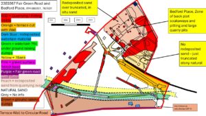
Remains of ditch fills that could be associated with the ramparts/town boundary shown on the 17th-century Down Survey, as shown on a map overlay, which shows them running through this area; these were suggested by gravel surfaces that seemed to line the sandy ditch bases. However, the 2024-2025 works were only 1.2m deep max. and this was slightly too limited in depth to be conclusive. The gravel surfaces remain in situ around 0.8m (west: c.38.95m OD at Fair Green Road) to 1.2m (east around 36.3m OD) below present ground level. Pottery from the presumed ditch fills on top of these gravel surfaces was distinctly 19th century and seemed to show the possible ditches were regularly cleaned out until they went out of use with the rebuilding of this entire area in the mid-19th century.
In Bedford Place were a series of small soakaways that probably represented back plot activity for a row of ‘cabins’ on the 1837 OS. These cabins were all swept away during a massive and extensive phase of open-cast sand and gravel quarrying that seems to have levelled off the top of Infirmary Hill, giving it the present, distinctive flat top as opposed to the lumpy image shown on the 1756 Williams Map. This quarrying/landscaping seems to have immediately preceded the gravel surfacing of Fair Green and Bedford Place around the 1840s to 1850.
The southern area of Fair Green showed very deep deposits (over 2m) that raised the ground well above the adjacent Circular Road. Some of these deposits might have been upcast from digging and deepening the nearby Leighsbrook Stream channel and Circular Road and/or have been part of large wet, ditch fills. Again, works were too limited to allow a clear interpretation in this area, but it seems to have been an attempt to raise this zone so that the Fair Green in this area above the possible 17th-century rampart ditches did not slope excessively. The 20th-century retaining wall (2m high of masonry faced with modern concrete) to Circular Road was retained in situ.
Works in Fair Green Road showed a distinctive lack of quarry pitting. However, as with elsewhere, the whole of Fair Green Road appeared to have been built on natural sand that had been truncated horizontally– which was presumably open-cast extraction – when the road was laid out when the St Mary’s RC Church + Loreto Convent were built c.1835.
- Area 6: Old Sheep Market and Church Hill
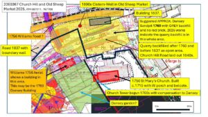
This area of c.80m east-west x 35m seems to have been a large, 18th-century quarry pit that might be referenced as belonging to Richard Dansey[1] who had a sand quarry pit ‘adjacent’ to St Mary’s Church of Ireland church. This pit was backfilled with lensing, grey sandy-gritty material that could have been sand/dredging recovered from works (weirs, mills, bridges etc.) being completed in the River Boyne. There were occasional animal bones but a distinct lack of any Georgian-era red brick fragments. The ‘Dansey’ quarry might be suggested on the 1756 Williams Map of Navan but is clearly backfilled by the time of the 1837 OS. Subsequently, this part of Navan was wholly demolished and rebuilt in the 1840s as seen by the overlay of the 1837 OS and the 1854 Bedford Estate map. Old Cornmarket was extended to the south at this time, with the old road that ran along the outside of the ‘Town Wall’ in this area being erased and realigned as the present Fair Green Road to Church Hill Road. Church Hill is labelled ‘New Road’ on the 1854 map, which also shows the newly-built Bedford Place buildings (1852). Old Sheep Market is laid out as a ‘Building Plot’ in 1854, but was retained as an open area in front of the Forester’s Hall (built 1880s).
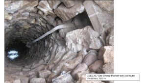
In the 1890s, perhaps around 1896-7 when Navan received its first water supply system, a large well/cistern was built in the Old Sheep Market, complete with a 2-inch diameter outflow lead pipe (an inflow pipe may have been previously removed). The well was 0.8m in diameter internally and 10m (perhaps originally 10.6m) deep. Old Sheep Market in the area of the well has a present ground level of 41.25m OD. The top of the water level in 2025 was 4.5m below the (truncated) top (i.e. 36.15m OD). The base of the well is around 30.5m OD which is roughly the same level of the River Boyne today. There is around 6m of water (around 3 cubic metres/3 tonnes of volume) being held in the well. The well shaft was dry stone built (where visible) and the structure was preserved in situ as a focal point.
[1] https://www.navanhistory.ie/st-mary-s-church-of-ireland/