2024:851 - New Children's Hospital, St James’s Hospital Campus, James's Street, South Circular Road, Mount Brown, Dublin 8, Dublin
County: Dublin
Site name: New Children's Hospital, St James’s Hospital Campus, James's Street, South Circular Road, Mount Brown, Dublin 8
Sites and Monuments Record No.: DU018-020 Zone of Archaeological Potential (ZAP) for Dublin City, DU018-020304 Foundling Hospital, and DU018-020305 Workhouse .
Licence number: 17E0148
Author: Steve Hickey
Author/Organisation Address: c/o AMS, Fahy's Road, Kilrush, Co. Clare
Site type: Cobbling and Grand Canal stilling basin
Period/Dating: Multi-period
ITM: E 713500m, N 733500m
Latitude, Longitude (decimal degrees): 53.339546, -6.295656
Between 2017 and 2024, on behalf of the National Paediatric Hospital Development Board (NPHDB), Archaeological Management Solutions (AMS) carried out archaeological monitoring of groundworks associated with the construction of the New Children’s Hospital at the St James’s Hospital campus, Dublin 8.
The site is located within an area of recognised archaeological and historical potential, in proximity to a number of previously recorded monuments and sites associated with the post-medieval expansion of the city and the former South Dublin Union complex. Several previous phases of archaeological investigation and monitoring have been undertaken within the area, reflecting the sensitivity of the receiving environment.
The NCH monitoring works were informed by extensive desk-based research carried out in advance of the development works. Pre-development research comprised an archaeological heritage chapter in the Environmental Impact Statement carried out by Courtney Deery (Chapter 15, Courney Deery 2015), a Battlefield Survey by Archaeology and Built Heritage (Myles 2017), and two Supplementary Historical Research Reports on the site by AMS (Coldrick 2016).
Between 2016 and 2018 following the demolition of existing buildings on site, and prior to the monitoring works covered under licence 17E0148, a combined total of 84 archaeological test trenches were excavated across the footprint of the proposed NCH under Licences 16E0408 (Breen, Shanarc Archaeology) and 17E0121 (Murphy, Archaeological Consultancy Services Unit (ACSU). AMS was appointed Project Archaeologist by the NPHDB and oversaw these works. Test trenching revealed foundational post-medieval structures and surfaces, remnants of canal architecture, and nineteenth-century walls/foundations. As a result, three areas were subject to further excavation (Breen & Garahy Licence no. 16E0621; Breen & Garahy 2017, Licence no. 16E0595; and Murphy 2017, Licence no. 17E0112). Following the completion of these works, it was further recommended that archaeological monitoring be undertaken across this extensive area in locations subject to demolition, bulk ground reduction, and associated groundworks (trenching/pipelaying) within the western and north-eastern parts of the campus. It is these monitoring works that were carried out under Licence no. 17E0148 by AMS.
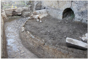
The principal archaeological features identified during the monitoring comprised the stone-built canal-related structure of nineteenth-century date, a cobbled surface interpreted as a former yard surface associated with housing in the Mount Brown area, which contained an earlier post-medieval cobbled surface below it, and a section of limestone wall recorded beneath the South Circular Road.
All archaeological monitoring was carried out under Licence no. 17E0148, issued by the National Monuments Service (NMS) to Ed Danaher of AMS in accordance with an agreed Method Statement (Danaher & Clutterbuck 2017). This monitoring licence was transferred to Joe Nunan (AMS) who undertook all monitoring works at the site from 2018 to 2023. In early 2023 the licence was subsequently transferred to the author Steve Hickey (AMS) who completed the monitoring brief on the remaining works, ceasing in July 2024.