2024:699 - TULLOW: Tullow WWTP, Tullowbeg, Carlow
County: Carlow
Site name: TULLOW: Tullow WWTP, Tullowbeg
Sites and Monuments Record No.: CW008-102
Licence number: 23E0086 ext. & 23R0070 ext.
Author: Padraig Dunne and Katherine Hurley, TVAS (Ireland) Ltd
Author/Organisation Address: Ahish, Ballinruan, Crusheen, Co. Clare
Site type: House - medieval, Enclosure and Kiln
Period/Dating: Multi-period
ITM: E 685000m, N 672495m
Latitude, Longitude (decimal degrees): 52.796752, -6.739592
Archaeological excavation was undertaken on the site of a proposed new wastewater pumping station and associated pipeline in a greenfield site adjacent to the River Slaney and the town of Tullow, Co. Carlow following a programme of test trenching (licence 23E0086). Archaeological excavation took place at the site of the new wastewater pumping station, its associated access road, the pumping station outfall and the rising main pipe route. Artefactual evidence suggests that the majority of features are medieval or early post-medieval in date, with tentative hints of prehistoric activity also noted.
Excavation at the proposed development commenced with the stripping of topsoil at the proposed access road associated with the new pumping station at the northern end of the development area. The northern extent of the excavation area was subject to heavy disturbance, likely related to the construction of a large retail outlet to the immediate north. Land reclamation works resulted in further disturbance at the eastern end of the pumping station outfall.
Access road
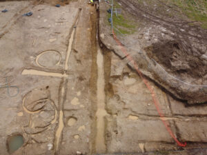
The access road extended from the north-western end of the excavation area north-eastwards to the new pumping station site, was 6–6.5m wide and proved to be highly archaeologically significant. Several ditches/gullies were recorded here, varying in width from 0.16m to 1.92m and these were 0.08–0.76m deep with varying fills throughout. Many of these ditches/gullies were parallel, aligned from north-west to south-east continuing beyond the limit of excavation at either end.
The remains of a possible figure-of-eight structure were recorded at the western end of the excavation area, consisting of two intertwined, roughly-circular ring gullies. Surviving poorly, primarily due to the loose, gravelly underlying geology, this possible structure measures 9.74m long, 5.46–5.7m wide and the gullies were 0.1–0.41m deep. The northern extent of the eastern circuit continues beyond the limit of the excavation. The eastern circuit appears slightly larger with an internal diameter (east to west) of 4.28m compared to 3.29m on the western circuit. No associated features were found.
A large sub-rectangular kiln measured approximately 5.39m by 3.52m and was 0.87m deep with a possible flue extending a further 4.28m to the east. This stone-lined kiln was filled with laminated layers of charcoal and re-deposited natural subsoil, suggestive of a prolonged period of use. A pit cut into the base of kiln measured 1.14m in diameter and 0.29m deep.
Several pits were also recorded, including a modern animal burial which remains partially preserved in situ to the south.
Pumping station site
The pumping station area extends to the east and south of the access road, forming a somewhat square area of approximately 0.2ha. The ground drops down to the east towards the river and the eastern part of the site is within the water table, remaining flooded for most of the period of excavation. Most of the archaeological remains here were concentrated at the western extent, on the higher, drier ground.
Additional ditches were recorded here, the most significant of which was visible for a length of 46.68m and was up to 3.53m wide and 1.03m deep. Likely medieval in date, the ditch is aligned approximately north-west to south-east, continuing beyond the limit of the excavation at both ends. An associated bank up to 2.1m wide was noted along its eastern edge, while at least two large post-holes were cut into the base of the ditch at the north. A smaller ditch with a v-shaped profile runs parallel to this to the east.
Several roundhouses were noted to the east of the main ditches. The southernmost roundhouse appears penannular in plan with an entrance noted at the north-west. The gully was up to 0.54m wide and 0.17m deep with a consistent fill throughout. An internal diameter of 3.76m was recorded. Further roundhouses were recorded to the north. Here several intercutting gullies were excavated, each appearing to occupy a similar space. At least two circuits can be identified, with additional gullies perhaps representing internal divisions, repairs or additions. The northern of the two appears to be open to the east, with an internal diameter of 4.98m, while the southern circuit appears open to the south with an internal diameter of 3.32m. Several pits and stake-holes recorded in the vicinity of the gullies are doubtless related.
A hearth at the south-east, measuring approximately 2.88m by 2.04m and 0.2–0.3m deep was cut into the medieval ditch. The hearth was stone lined, while the fills include laminated layers of charcoal. Several fragments of quern stones were recovered from the fills and the stone lining itself.
Several large pits and a cluster of stake-holes were recorded at the northern extent of the excavation area, while a number of field system gullies were recorded, concentrated to the south-east.
Pumping station outfall trench
The proposed pumping station outfall trench extends south-east of the pumping station area, turning to the east and splitting into two segments at the junction with the proposed rising main which continues to the south. Here topsoil was stripped along an approximately 10m wide trench within the proposed pipe route corridor, with the remainder 10m along the west to south-west and south utilised for spoil storage.
Additional ditches and gullies were recorded in this area, many likely post-medieval to modern in date and concentrated to the north-west and south-east. These ditches/gullies varied in length from 0.96–18.12m, were 0.35–3.1m wide and 0.1–0.72m deep, with fairly homogenous fills throughout and visible along varying alignments. Several pits and post-holes were found scattered throughout the area, along with a palaeochannel traversing the excavation area
Rising main pipe route
The rising main pipe route continued south from the outfall trench, turning south-west across two fields towards the existing wastewater treatment plant. Topsoil was stripped along an approximately 10m-wide trench within the proposed pipe route corridor, with the remainder 10m along the west and north utilised for spoil storage.
Several ditches/gullies, most of which appeared to be associated with previous field boundaries, were noted in this area, on varying north-west to south-east and east to west alignments. These ditches varied in length from 6.34–36.43m, were 0.44–2.59m wide and 0.02–0.93m deep, with fairly homogenous fills. A number of pits were also scattered throughout this area, one of which contained a modern animal burial, concentrated towards the northern extent, while numerous cultivation furrows were concentrated closer to the existing wastewater treatment plant.
Recorded Monument CW008-102 (Designed landscape feature – tree ring), and another similar feature nearby, were partially excavated along the north-east to south-west aligned segment of the rising main pipe route, presenting as wide, arced ditches, extending into the excavation area from the northern face of the trench. The ditches were visible for a length of 15.73–20.2m and 15.15m respectively, were 3.48–4.14m wide and up to 0.73m deep. Partially extant stone facing survived along the inner ditch face of Recorded Monument CW008-102, with rubble noted throughout the fills of both features. These features remain partially preserved in situ to the north.