
2023:890 - Trim Millennium Bridge, Meath
County: Meath
Site name: Trim Millennium Bridge
Sites and Monuments Record No.: ME036-048--- / ME036-048004 / ME036-048021
Licence number: E005431
Author: Niall Roycroft
Author/Organisation Address: c/o Meath County Council, Buvinda House, Dublin Road, Navan, Co Meath. C15 Y291.
Site type: Historic Town
Period/Dating: Late Medieval (AD 1100-AD 1599)
ITM: E 680206m, N 756845m
Latitude, Longitude (decimal degrees): 53.555388, -6.789511

Meath County Council is proposing to replace the demolished, wooden Trim Millennium Bridge which was replaced with an adjacent temporary Bailey Bridge (supplied by Irish Defence Forces) in 2022. The Millennium Bridge was originally constructed in 2001 beyond the north-west corner of Trim Castle with a southern, mass concrete abutment in the area of the presumed Trim Castle moat connection to the River Boyne. This area also is in a location for a possible ‘back-channel’ of the River Boyne running past the southern side of the Franciscan Friary, ME036-048025 (potentially making the Friary located on an in-channel ‘island’). The area of the Millennium Bridge was infilled and landscaped during the post-medieval period and more recently it has been used for ground raising dumps from the OPW Boyne Drainage Works c.1970. Further landscaping occurred during the general Trim Castle works of the 1990s. The northern mass concrete 2001 abutment, ITM 680229, 756871, is near to the walled boundary of Talbot Castle which was associated with St Mary’s Abbey (Trim).
Site Investigation (SI) monitoring of Investigation Pits SI.1 and SI.2 took place in October 2023. Further SI works of two Rotary Cores (RC.1 and RC.2) and two cable and percussion boreholes (BH.1 and BH.2) were reviewed as part of the reporting.
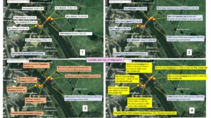
On the southern side of the River Boyne, SI.1, BH.1, RC.1 and the topographic survey recorded the top of bedrock as 49.57m OD to 50.77m OD. On the northern side of the River Boyne, SI.2, BH.2, RC.2 recorded the top of bedrock as 49.24m OD to 50.96m OD. The southern difference in bedrock levels could be natural or man-made. However, the northern low bedrock level of 49.24m OD (BH.2) would be a good location for a wharf, quay or similar riverside structure for St Mary’s Abbey (it is also opposite the ‘Water Gate’ for Trim Castle and approached by a historic road/access from St Mary’s Sheep Gate).
On the southern side bedrock was overlain by a 0.5m to 0.6m thick combination of gravels/cobbles (RC.1, BH.1) and mixed wetland-smelling blue grey and soft, dark brown waterlain material (SI.1) with a top level of 50.77m OD to 51.05m OD. These deposits probably represent in-channel deposits and gravel bars/islands. On the northern side, bedrock was overlain by a 0.5m to 1m wetland-smelling blue gravelly grey and soft, dark brown waterlain material with a top level of 50.34m OD to 51.3m OD. Again, the level in BH.2 was significantly lower. These waterlain deposits contained oyster (i.e. marine) shells which were presumably medieval to post-medieval food waste.
The waterlain deposits were overlain by historic floodplain of mid-brown silty clay deposits which, on the southern side were 0.4m to 0.6m thick with an upper level of 51.6m OD to 52.07m OD. On the northern side, these deposits were 0.3m to 1m thick up to 51.6m OD to 52.54m OD. This is the floodplain as seen in old photographs.
On the southern side SI.1 revealed a masonry wall cutting the historic floodplain levels. This is one wall of a drain culvert or mill outflow that is seen in historic photographs running alongside the River Boyne. It was also noted in the original 2001 monitoring, 01E0262, and has also probably been truncated by the nearby OPW water (for the 1990’s Castle moat) extraction point.
Above the historic floodplain deposits on both sides of the River Boyne was a general 0.7m deep deposit of dumped dredgings from the 1970’s Boyne Drainage Works, to a level of 52.3m OD to 52.7m OD. These dredgings have a high archaeological potential, but nothing was noted in these layers.
The top deposits were all post-1990’s landscaping (often ‘Clause 804’ gravels/chippings) reaching present ground level of 52.85m OD to 53.67m OD on the southern side and 53.04m OD to 53.9m OD on the northern side.