2023:855 - Milltown, Brownsrown and Loughtown Upper, Dublin
County: Dublin
Site name: Milltown, Brownsrown and Loughtown Upper
Sites and Monuments Record No.: N/A
Licence number: 23E0736
Author: Chris Coffey
Author/Organisation Address: IAC Ltd, Unit G1 Network Enterprise Park, Kilcoole, Co. Wicklow
Site type: Kilns and hearths
Period/Dating: Undetermined
ITM: E 701566m, N 731498m
Latitude, Longitude (decimal degrees): 53.323985, -6.475428
A programme of archaeological testing took place at Grange Castle West, within the townlands of Milltown, Brownstown, and Loughtown Upper, Co. Dublin prior to groundworks for a construction compound (ITM 701063, 731430). There are three recorded monuments located within c. 500m of the proposed site including a burial ground (DU017-108), earthwork (DU017-111), and an enclosure (DU017- 095).
Test trenching commenced at the site on 12 October 2023 and continued for three days. A total of 10 trenches were excavated across the site measuring 1380 linear metres and targeted geophysical anomalies identified in the previous assessment (Nicholls 2018, Licence No.18R0222) as well as open green space.
Topsoil was a mid/greyish-brown sandy clay with an average depth of 0.3m and was uniform across the site. The subsoil was as a heavily mottled grey/yellow clayey sand with frequent intercutting bands of decayed shale.
Archaeological remains were identified in four locations (AA1-4) along with a limited amount of former agricultural evidence, as described below.
- Archaeological Area 1 (AA1)
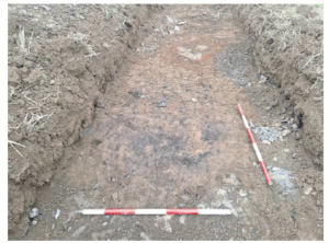
AA1 is located within Trench 3 and consists of a shallow ring of fire-reddened clay (C3), flanked 1m to its south by a spread of charcoal (C5), which may represent the remains of an oval charcoal-production kiln. C3 measures 1.2m long by 0.85m wide. C4 measures 1.3m by 1m. - Archaeological Area 2 (AA2)
AA2 is located within Trench 4 and consists of a shallow sub-circular patch of fire-reddened clay with occasional charcoal and likely represents the partial remains of a small hearth (C7). - Archaeological Area 3 (AA3)
AA3 is located in Trench 6 and similar to AA2 comprises the partial remains of a probable small hearth identified by a sub-circular patch of fire-reddened clay with occasional charcoal (C9). - Archaeological Area 4 (AA4)
AA4 consists of a possible keyhole-shaped kiln (C12) identified within Trench 10. C12 measures c.0.9m in length and 0.08m in depth. The bowl of the feature measures 0.85m in width with a potential flue located on the northern side measuring 0.07m in width. In situ burning was recorded along the eastern side of C12.