2023:262 - BARNAGEERAGH, BREMORE, COLP EAST, COLP WEST, CORBALLIS, DONABATE, EFFELSTOWN, IRISHTOWN, GORMANSTON, KNOCKNAGIN, MINISTOWN, NICHE, TANKARDSTOWN, Dublin
County: Dublin
Site name: BARNAGEERAGH, BREMORE, COLP EAST, COLP WEST, CORBALLIS, DONABATE, EFFELSTOWN, IRISHTOWN, GORMANSTON, KNOCKNAGIN, MINISTOWN, NICHE, TANKARDSTOWN
Sites and Monuments Record No.: N/A
Licence number: 22E0623
Author: Thaddeus Breen & Marion Sutton; Shanarc Archaeology Ltd.
Author/Organisation Address: Unit 39A, Hebron Business Park, Hebron Road, Kilkenny
Site type: No archaeology found
Period/Dating: N/A
ITM: E 720301m, N 763958m
Latitude, Longitude (decimal degrees): 53.611625, -6.181925
Archaeological monitoring of exploratory Ground Investigation (GI) works associated with the DART+ Coastal North Project, a railway improvement project under the DART+ Programme, was carried out between August 2022 and January 2023.
The monitored Ground Investigation (GI) works consisted of inspection pits and test pits, with some sited online, i.e. on or immediately beside existing railway lines, which were excavated at night, while others were sited offline in adjacent fields. Online GI pits were dug with a vacuum excavation machine and deepened by hand. The stratigraphy was recorded and the sampled material checked for artefacts.
Most of the GI works monitored were vacuum-excavated to a depth of about 1m, and subsequently deepened by hand by an additional 0.2m. Samples taken for engineering purposes and the spoil from hand-digging were examined to establish the nature of the material and the presence or absence of artefacts. The stratigraphy of the pit itself was examined and recorded. In the case of the on-track work, conditions were less than optimal, as the pit was often a narrow circular hole, which had to be observed under artificial light, as the work on the railway had to be carried out at night. Where necessary, the beginning of the drilling was also observed, or the drillers’ logs consulted
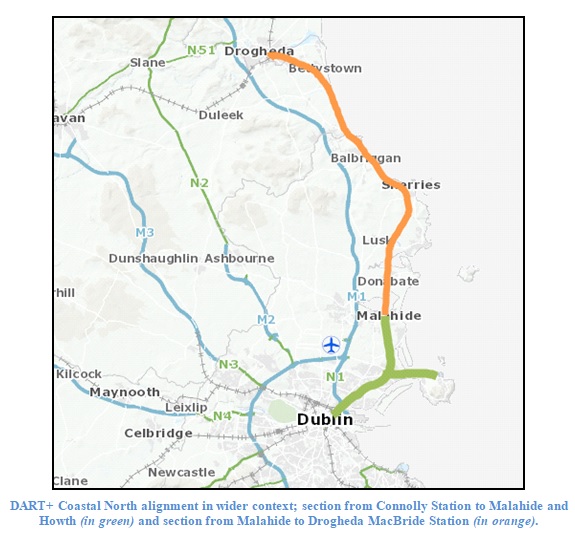
The bulk of the GI works are located between Malahide Station and Drogheda MacBride Station, which has yet to be electrified, the alignment passing by way of Donabate Station, Rush & Lusk Station, Skerries Station and Balbriggan Station in Co. Dublin, and between Gormanston Station and Laytown Station in Co. Meath, to Drogheda MacBride Station in Co. Louth.
In total 35 GI pits and test pits were archaeologically monitored. Monitored locations were situated in the following townlands, all in Co. Dublin; Barnageeragh, Bremore, Colp East, Colp West, Corballis, Donabate, Effelstown, Irishtown, Gormanston, Knocknagin, Ministown, Niche and Tankardstown,
Most of the findings from on-track GI monitoring reflect 175 years of railway construction and use. The railway is constructed on a layer of ballast, 0.3–0.5m thick, over compacted clay.
The use of vacuum excavation meant that most of the spoil was taken away and dumped elsewhere, so that only the samples and the spoil from hand-digging could be inspected for artefacts. No artefacts were found.
The off-track locations that were monitored were on agricultural land. No archaeological features or artefacts were noted.