2021:800 - Wolfe Tone Park & Wolfe Tone Street, Dublin 1, Dublin
County: Dublin
Site name: Wolfe Tone Park & Wolfe Tone Street, Dublin 1
Sites and Monuments Record No.: DU018-020322-
Licence number: 20E0605
Author: Thaddeus C. Breen; Shanarc Archaeology Ltd.
Author/Organisation Address: Unit 39A, Hebron Business Park, Hebron Road, Kilkenny
Site type: Urban
Period/Dating: Post Medieval (AD 1600-AD 1750)
ITM: E 715397m, N 734505m
Latitude, Longitude (decimal degrees): 53.348164, -6.266818
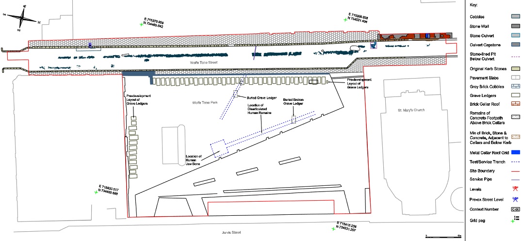
A programme of archaeological monitoring and excavation was carried between 4 November 2020 and 21 September 2021, in relation to the Wolfe Tone Park and Street Environmental Scheme, a public realm improvement scheme implemented by Dublin City Council incorporating Wolfe Tone Park, previously the location of the former graveyard associated with St Mary’s Parish Church, and the adjacent Wolfe Tone Street (to the west of the Park). St Mary’s Parish Church is a recorded monument (RMP: DU018-020322-), and a protected structure (RPS: 5056) dating to c. 1700, and its graveyard was used from this time until the later 19th century.
Monitoring of groundworks within Wolfe Tone Park, which were designed to keep excavation works and formation levels to a minimum in acknowledgement of the Park’s previous use as a graveyard, exposed no burials. Disarticulated human remains and broken grave ledger fragments are present in disturbed graveyard material from c. 0.25m below the surface, with more intact grave ledgers exposed c. 0.7m below the surface, which is consistent with the results of previous archaeological investigations undertaken in the Park.
Wolfe Tone Street (formerly Stafford Street) was fully laid out and developed by 1728, and its early 18th-century cobbled road surface survived, albeit in a disturbed and fragmented state. The cobbled road surface formed the focus of excavation and recording prior to its removal. Evidence for surviving brick cellars below the footpath on the west side of the street was also recorded at the north end of the street, which may relate to the earliest houses built on the street in the early 1700s. The brick cellars remain in situ. There is potential for partial cellar remains to survive elsewhere on the west side of the street.
The finds/objects recovered during monitoring and excavation range in date from the 16th to the 20th centuries, with the bulk of the finds comprising, pottery, clay-pipes, glass and various metal objects, ranging in date from the 17th to the 19th centuries.