2021:627 - METROLINK (PHASE 5); Dunlin County: Lissenhall Little/Cloghran/Ballystraun/Dublin Airport/Ballymun/Santry Demesne/Dublin CIty, Dublin
County: Dublin
Site name: METROLINK (PHASE 5); Dunlin County: Lissenhall Little/Cloghran/Ballystraun/Dublin Airport/Ballymun/Santry Demesne/Dublin CIty
Sites and Monuments Record No.: DU018-020
Licence number: 19E0152
Author: Thaddeus C. Breen; Shanarc Archaeology Ltd.
Author/Organisation Address: Unit 39a, Hebron Business Park, Hebron Road, Kilkenny
Site type: Historic town
Period/Dating: Multi-period
ITM: E 715796m, N 734789m
Latitude, Longitude (decimal degrees): 53.350628, -6.260725
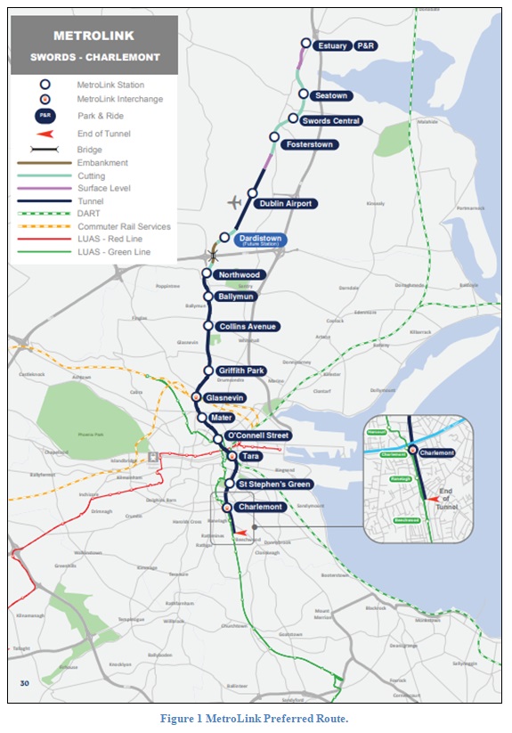
Five phases of archaeological monitoring of test pits and boreholes was carried out for preliminary Geotechnical Investigation (GI) along the line of the proposed MetroLink project. The proposed route runs from Lissenhall (Estuary Station), Swords in the north to Ranelagh in the south. The works were monitored under licence no. 19E0152, with works in St Stephen’s Green Park National Monument (RMP DU018-020334-) monitored under Ministerial Consent No. C001054.
The GI sites covered a range of environments from rural through suburban to inner city and were generally dug to a length, width and depth of 1m x 0.4m x 1.2m. In the rural part, in the townland of Ballymun, a flint flake was found on nearby ploughed ground, but nothing was found in the pits or boreholes. At Lissenhall Little, near Swords, a geophysical survey indicated the presence of extensive below-ground archaeological features, but nothing was found in the boreholes, which were positioned to avoid the location of these potential archaeological remains.
In the suburban area, occasional potsherds of 18th-20th-century date were found, along with fragments of brick, slates and mortar. In Glasnevin, behind the Hedigan’s/Brian Boru public house, a cobbled surface was found, adjoining a brick and stone structure. The objects and stratigraphy suggested a 19th-century date, but only a small area was exposed. Nearby, some test pits on the north bank of the Royal Canal’s 5th Level investigated the stone wall of the canal, but could only be dug to a depth of 0.5m owing to water seepage.
Closer to the centre, in Berkeley Road and Eccles Street, 19th-century stone setts were found in situ, where the modern road surface has simply been laid down over the older road. In the grounds of St Joseph’s Church, Berkeley Road, close to the north-west wall of the church, a brick sewer chamber was found 3m below current ground level. This chamber was a further 1.5m deep, and, as exposed, measured 2m in length by 1.5m in width.
In the city centre, only brick and slate fragments were found, but in a yard bounded by Poolbeg Street and Tara Street, shown as ‘Pounden’s Foundrey’ on Rocque’s Map of 1756, a sherd of post-medieval pottery was found on levels interpreted as representing the pre-reclamation riverbed. A deposit of roof tiles and rubble was found in the grounds of Trinity College Dublin (in proximity to the Zoology Building) along with a dump of oyster shells. In Hume Street, the brick cellar of No. 18 (demolished c. 1969) was found. The cellar crown was found intact and was protected in situ with no further exploratory works as to its nature and composition undertaken.