
2019:877 - Dunkellin Flood Relief Scheme (Craughwell Bridge), Galway
County: Galway
Site name: Dunkellin Flood Relief Scheme (Craughwell Bridge)
Sites and Monuments Record No.: GA096-185
Licence number: C860, E5000
Author: Dominic Delany
Author/Organisation Address: Dominic Delany & Associates
Site type: Bridge
Period/Dating: Post Medieval (AD 1600-AD 1750)
ITM: E 551032m, N 719961m
Latitude, Longitude (decimal degrees): 53.227786, -8.733374
Archaeological monitoring of bridge deck investigations took place in May 2019, when two bays were opened across the tops of the two southernmost arches. The modern cobble-lock paving had been removed in advance of the works. The asphalt surface (Thickness: 0.05m) and underlying compact grey/white sand, gravel and stone fill (Thickness: 0.1m) were removed using a mini-excavator and the bays were then excavated by hand down to a solid surface. The investigations revealed a compact mortared and cobbled surface across much of the deck. The cobbling is confined to the west extent of the bridge suggesting the earlier bridge had a cobbled deck, the remains of which were incorporated into the mortared deck of the Phase 3 bridge. The top of the arches lay immediately below the mortar/cobble surface, and there was a loose stone fill between the barrels of the arches. It was established that there was significant water ingress into the barrels of the structure.
Craughwell Bridge was subject to a comprehensive archaeological assessment in 2018 (2018:936). A programme of channel-deepening and underpinning works was carried out within the two southernmost arches between August and November 2019. First the paving stones were cut c.100mm in from the pier wall face so as not to undermine the walls when removing the stones. The paving stones were then lifted and a 1m-deep channel excavated into the underlying natural sand, gravel and stone deposits. Finally, a new V-shaped concrete channel was shuttered and poured. The mid-19th-century Phase 4 underpin was revealed to extend to a depth of 1.2m beneath the Phase 3 wall. It was faced with roughly-worked rectangular limestone blocks and rested on a foundation of large rectangular boulders and smaller packing stones. The only other structural work undertaken at the bridge was the takedown and rebuild of one of the upstream cutwaters, which had been de-stabilised by a sycamore tree. Much of the structure had to be taken down to facilitate the removal of the tree root. Upon completion of the bridge upgrade works, a new concrete-imprinted bridge deck surface was laid over a waterproof membrane.
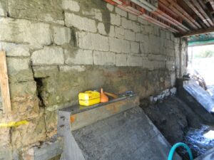
C860, E5000: Craughwell Bridge – Pier Wall underpin