2019:222 - KINSALE: Actons Hotel, Pier Road, Cork
County: Cork
Site name: KINSALE: Actons Hotel, Pier Road
Sites and Monuments Record No.: CO112-034001
Licence number: 19E0676
Author: David Murphy, John Cronin & Associates
Author/Organisation Address: 3 Westpoint Business Centre, Ballincollig, Cork
Site type: Historic town
Period/Dating: Medieval (AD 400-AD 1600)
ITM: E 563960m, N 550269m
Latitude, Longitude (decimal degrees): 51.703649, -8.521428
Testing was undertaken at the site of a proposed ancillary accommodation block in the north-western corner of the Actons Hotel site on 31 October and 1 November 2019. This area straddles the southernmost extent of the historic medieval walled town of Kinsale (CO112-034001-) and currently consists of modern flat-roofed structures, a storage/refuse area and a natural gas-related installation which are situated to east of a c.5m high retaining wall which separates the site from Lower O’Connell Street above and to the west. Two 8m long and 1m wide test trenches, orientated roughly north-west to south-east, were excavated across an existing concrete yard area which forms the location of the proposed ancillary accommodation block. The test trenches (Trench 1 to the west and Trench 2 to the east), which were spaced between 1.5m and 2m apart, were excavated across the long axis of the proposed structure. Due to onsite constraints, this was the maximum available space for trenching within the area.
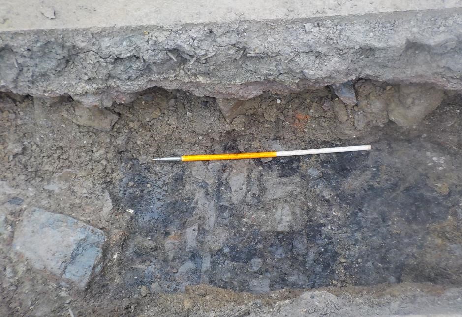
The concrete slab and its underlying base material measured between 0.3m and 0.5m thick. The underlying stratigraphy in both trenches was broadly similar with stratified deposits of demolition material containing rubble, masonry stone, brick, plastic, metal and modern ceramics extending to a depth of between 0.7m to 0.9m below modern surface level (bmsl) in Trench 1 and 0.9m and 1.1m bmsl in Trench 2 (this reflects the natural downward slope to the east of the topography of the area). At the southern end of both trenches a modern concrete surface was revealed underlying the demolition deposits at a depth of 0.85m to 0.9m bmsl. This surface extended c.2.8m northwards from the southern end of each trench. Natural bedrock and a firm clayey silt subsoil were revealed in the central portions of both trenches at a depth of between 0.7m and 0.9m bmsl. The bedrock had the appearance of being quarried or truncated.
The only feature of note revealed within the excavated trenches was a concentration of elongated, cobble-like stones which was at the northern end of both trenches. The possible stone surface was revealed at a depth of 0.9m bmsl in Trench 1 and 1.1m bmsl in Trench 2. The stones were set within a deposit of compact, dark grey to black, charcoal-rich, sandy silt in Trench 1; however, this surrounding deposit was not readily evident in Trench 2. The stone surface measured at least 0.75m in width (north-south) in Trench 1 but may have extended beneath the charcoal-rich deposit which continued to limit of the trench, 2.3m north-west of the southern extent of the revealed stones. In Trench 2, the stone surface comprised more randomly aligned narrow and elongated stones and extended c.2.5m south of the northern limit of the trench. The surface, which appeared to have an east to west alignment, is most likely early modern in date and may represent a yard or lane area associated with late 18th- or 19th-century development in this area. No medieval archaeological remains were revealed within the excavated trenches.