2018:936 - Dunkellin Flood Relief Scheme (Craughwell Bridge), Galway
County: Galway
Site name: Dunkellin Flood Relief Scheme (Craughwell Bridge)
Sites and Monuments Record No.: GA096-185
Licence number: C860, E5000
Author: Dominic Delany
Author/Organisation Address: Dominic Delany & Associates
Site type: Bridge
Period/Dating: Post Medieval (AD 1600-AD 1750)
ITM: E 551032m, N 719961m
Latitude, Longitude (decimal degrees): 53.227786, -8.733374
Archaeological monitoring of trial hole investigations took place at Craughwell Bridge in January 2018. Two trial holes were opened at the base of the two southernmost arches to assess the pier wall foundations, which in both instances consisted of a single large roughly-hewn rectangular limestone block, which projected under the face of the wall. Paved stone floors were exposed in section within both arches. The proposal at this time was that all six arches would be deepened and the pier walls underpinned. In the summer of 2018, the three southern arches, all of which are on dry land, were excavated and the paved stone floors recorded. The project was subsequently re-designed and only the northern two arches were scheduled for deepening and underpinning. These two arches were excavated and recorded after the river was diverted into the bypass channel in late summer. A detailed archaeological assessment of the bridge was undertaken at this time, and four phases of construction were identified and recorded.
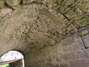
Phase 1: The original bridge is 3.1m wide, its 1.9m high arches now sandwiched between later extensions to the west (Phase 2), and to the east (Phase 3). The arch rings are composed of roughly-worked limestone voussoirs, some of which are partly-visible at the joints with the later extensions. The soffits preserve much of the wickerwork centering that supported the arches during construction, and the channel floor is paved with large irregular limestone boulders and smaller packing stones. The ashlar blocks facing the pier walls date from the third phase of construction, at which time the walls of the Phase 1 bridge were completely re-faced. A late 16th-or early 17th-century date has been suggested for the Phase 1 bridge.
Phase 2: The second phase of construction saw the bridge widened by 0.9m to the west. Projecting stones below the spring of the arch served as supports for the wooden framework used during the construction of the arches. The arch rings consist of worked voussoirs including several unusually large blocks, some of which serve as keystones. The pier walls are a mix of roughly-hewn limestones, the original build, and ashlar blocks, which date from the subsequent, third phase of construction. The paved floor is similar to the Phase 1 floor. A late 17th-century date has been suggested for this phase of construction.
Phase 3: The third phase of construction saw the width of the bridge almost doubled, with the addition of 3.4m to the east. The arches are more rounded than the earlier arches, and the rings are composed of cut and dressed limestone voussoirs. The pier walls are faced with ashlar blocks, and the floors are paved with large cobblestones and boulders, generally smaller than the boulders used in the Phase 1 floor. The V-shaped cutwaters on the upstream elevation are built of cut and dressed limestone blocks, and occasional roughly worked limestones. The parapet walls on the bridge deck are contemporary with this phase of construction. The walls consist of three courses of irregular limestone boulders and small packing stones, capped with large roughly-worked rectangular blocks, wedge-shaped blocks and upright slabs, the whole achieving a pleasing aesthetic appearance. The east wall contains at least four weep-holes, the openings framed by large irregular slabs and the gently sloping floors composed of small, flat stones. The weep-holes are positioned directly above the apex of the arches suggesting there were originally six such openings. There are no weep-holes in the west parapet wall.
Phase 4: The three northern arches were deepened and underpinned as part of the Dunkellin Drainage Works 1843-1857. The underpin extends to a depth of 1.2m and is distinguished by its use of squared, undressed limestone blocks. New paved floors were laid, presumably using some of the stone lifted from the pre-existing floors. Great care was taken with the paving within the northernmost arch where the finely paved surface was embellished by a fanlight arrangement of blocks at the upstream entrance to the arch. The three southern arches were not impacted by the Phase 4 works, and probably served as flood eyes after this date.
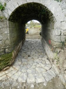
C860, E5000: Craughwell Bridge, Paved Floor to South Arch