2018:935 - Dunkellin Flood Relief Scheme (Killeely Beg, Rinn, Craughwell, Ballymore, Doonard, Aggard More, Crinnage or Ballywulash), Galway
County: Galway
Site name: Dunkellin Flood Relief Scheme (Killeely Beg, Rinn, Craughwell, Ballymore, Doonard, Aggard More, Crinnage or Ballywulash)
Sites and Monuments Record No.: N/A
Licence number: 16E0481
Author: Dominic Delany
Author/Organisation Address: Dominic Delany & Associates
Site type: Bridge
Period/Dating: Post Medieval (AD 1600-AD 1750)
ITM: E 551032m, N 719961m
Latitude, Longitude (decimal degrees): 53.227786, -8.733374
The Dunkellin River Flood Relief Scheme extends from c.200m upstream of Craughwell Bridge, to c.400m downstream of Killeely Bridge near Kilcolgan in South County Galway. The works are divided into three areas: Craughwell village and environs in the east extent of the scheme, Rinn Bridge west of Rahasane Turlough in the centre, and Dunkellin Bridge to Killeely Bridge in the west extent of the scheme.
The 2018 programme of works included river diversion, channel widening and channel deepening at Craughwell. The works area extended from c.200m upstream of the modern road bridge to c.850m downstream. Topsoil strip to facilitate river diversion and channel widening took place along the north bank of the river immediately west of Craughwell Railway Bridge, and along the south bank of the river at Aggard More. Once the new bypass channel became operational, the section of river running through the village was diverted and pumped dry to facilitate in-channel works. The dry riverbed was scanned for finds, and subsequent excavations within the channel were monitored but no artefacts of archaeological significance were found. The absence of any finds pre-dating the modern period is not surprising considering the riverbed was significantly reduced when the river was canalised in the mid-19th century. A detailed assessment of the late medieval bridge was undertaken, and trial holes were opened adjacent to the bridge arches, and on the bridge deck. These works were carried out with the benefit of ministerial consent, and are reported separately (2018:936).
In the west extent of the scheme monitoring of topsoil removal was carried out in the vicinity of Killeely Bridge, which was scheduled for demolition. The works were largely concentrated on the short approach road and lands on the south bank of the river. The purpose of the works was to improve access and facilitate the construction of the proposed new bridge. Monitoring of topsoil strip and excavations on the south bank of the river at Rinn Bridge revealed a fill of re-deposited soil and stone, which extended to a maximum depth of 1m at the riverbank and decreased in depth to the south. The fill petered out completely at the limit of excavation, some 15m south of the riverbank, where there was 0.2m of grey/brown sandy silt topsoil over 0.3m of yellow/brown sandy subsoil, over grey sand, gravel and stone natural.
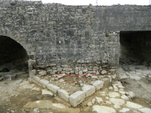
Ground levels on the west side of Dunkellin Bridge were reduced by approximately 0.7m in the first week of June 2018. The topsoil was 0.2-0.4m thick and overlay 0.7m of silty sand and gravel deposits with frequent small and medium stone inclusions. An archaeological assessment of the bridge was undertaken and it was established that it was significantly older than the previously-attributed 19th-century date. The existing wide-span bridge was built as part of the Dunkellin Drainage Works 1843-57, but the older bridge to the south incorporates two phases of construction and may date from the 17th century. The original bridge (Wth 4.25m) is a five-arch structure on the east elevation consisting of a central segmental arch with two smaller round-arches on either side. The four surviving arch rings have plain voussoirs (the northernmost arch is missing and rebuilt with a flat concrete head) and the pier walls preserve traces of former V-shaped cutwaters. Projecting corbels in the side walls indicate an arch-construction technique similar to that of the phase 2 bridge at Craughwell, which is tentatively dated to the late 17th century. The second phase saw the bridge widened by 3m to the west and reduced to a 3-arch structure (The two southern arches of the earlier bridge were not carried through). The arch rings are composed of finely-dressed voussoirs with slightly projecting keystones. An 18th-century date is suggested for this second phase bridge. The proposed re-development required the removal of the partly-modern northernmost arch, which was excavated and recorded in advance of demolition. A paved stone floor composed of large irregular boulders was uncovered within the 17th-century arch, and a floor of smaller slab-like boulders within the 18th-century arch. Monitoring of topsoil removal on the east side of the bridge revealed the foundations of V-shaped cutwaters on either side of the north arch.