2007:1689 - KILLALANE, Tipperary
County: Tipperary
Site name: KILLALANE
Sites and Monuments Record No.: N/A
Licence number: A026/010; A026/236; A026/277; A026/278; A026/279; A026/280; E2495
Author: Patricia Long, Headland Archaeology Ltd.
Author/Organisation Address: Unit 1 Wallingstown Business Park. Little Island, Cork
Site type: Excavation - miscellaneous
Period/Dating: Multi-period
ITM: E 575331m, N 670525m
Latitude, Longitude (decimal degrees): 52.785183, -8.365683
Archaeological investigation in advance of the N7 Nenagh to Limerick high-quality dual carriageway road project at Killalane took place between January and March 2007. Excavations comprised six areas (encompassing Ministerial Direction numbers A026/010, A026/236, A026/277–279 and A026/280) as well as two areas of archaeological testing undertaken in 2007.
A026/010
This site was located at the base of a steep north-east-facing slope, on the bank of a small stream which had recently been widened. Part of a large fulacht fiadh, measuring 14.4m long (north–south) by 7m wide and 0.3m deep, was identified. It had been truncated on its western side by the widening of the stream. No trough was identified and it is likely that is was obliterated by the truncation. A roughly circular pit filled with burnt-mound material measuring 1.4m in diameter and 0.25m deep was identified towards the centre of the site. It is possible that this functioned as a trough. Two more possible troughs with associated burnt-mound material were identified to the east and south-east of the main mound; they seem to represent separate episodes of fulacht fiadh activity. Eight shallow spreads (,0.1m deep) of burnt-mound material were identified across the site; this material appears to have been dragged from the main areas of activity by ploughing, etc. One piece of worked flint was recovered from the topsoil during the excavation.
A026/236
A number of features associated with a demolished vernacular house and two post-medieval field boundaries were identified in this area. The earlier of the boundaries measured 1.2m wide and 0.35m deep; this was truncated by a boundary measuring 1.1m wide and 0.2m deep. Both boundaries extended beyond the limits of excavation. The foundation of an outhouse associated with the vernacular house was also excavated; it consisted of a square stone platform measuring 4.6m wide and 0.3m deep. Several sherds of post-medieval pottery and corroded metal objects were recovered in the area of the platform. Both the boundaries and the outhouse are depicted on the first-edition OS map of 1840.
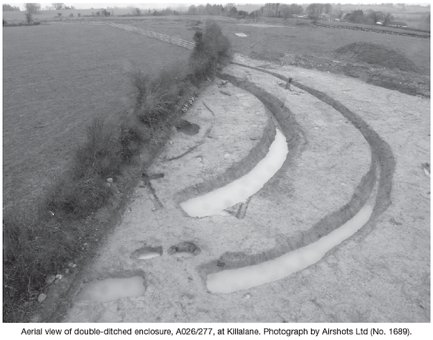
A026/277
Part of a substantial double-ditched enclosure was excavated in this area. The enclosure appeared to be oval in plan with a causewayed entrance on the south-east side. The inner ditch was between 2m and 3.3m wide and between 1.25m and 1.68m deep, while the outer ditch was between 1.25m and 2.37m wide and between 0.75 and 1.1m deep. The space between the two enclosing ditches was on average 7m wide. No artefacts were recovered from the ditch fills. An unlined corn-drying kiln was identified between the two enclosing ditches on the north side. It measured 2.45m long (east–west) by up to 1m wide and had a depth of 0.3m. Oxidised subsoil at the base indicated burning in situ and there was abundant charcoal and carbonised grain in the fill. The rounded west end of the kiln had a lip of clay around the top of the cut which could be the remnants of a covering.
Two large post-holes, both measuring 1.3m in diameter and c. 0.7m deep, were located on either side of the entrance, inside the outer ditch, possibly representing some kind of structural entrance feature.
Towards the centre of the enclosed area part of a possible curvilinear gully was seen to be surrounding a large pit. The portion of the pit within the road-take was oval in plan and measured 3.4m long (east–west) by 1.8m wide and 1.2m deep. The surrounding gully was between 0.06m and 0.32m wide and between 0.03and 0.22m deep. The curvature of the gully reflected that of the enclosing ditches; there was also slight evidence for possible beam slots within it. A carefully made stone-lined drain (measuring 0.4m wide and 0.36m deep) led away from the central pit beyond the road-take and a similar portion of drain was identified close to the entrance. It is likely that these are two portions of the same feature. Initial interpretation is that these drains are of archaeological significance and related to the central pit, which may have been a well or sump for water collection. A possible whetstone was the only artefact recovered during this excavation, therefore the dating of the site will be reliant on radiocarbon determinations. Geophysical survey by Target Archaeological Geophysics carried out on the unexcavated portion of the enclosure shows that its external diameter was c. 56m.
A026/278
No features of archaeological significance were identified on this site.
A026/279
A number of irregular features were identified on this site, some of which contained charcoal flecking. They were consistent with land clearance and animal burrowing and are unlikely to be of archaeological significance.
A026/280
Within this site a large fulacht fiadh, bordered by a stream, was identified. The mound, which measured 9.4m long (north-east/south-west) by 6.8m wide, had been severely truncated by modern drainage ditches but it was possible to see that it was situated on a slope that seems to have been the original stream bank. At the base of the slope the mound material had a maximum depth of 0.6m. It was also possible to identify two possible trough features, though both had been disturbed by the modern drains. One was located at the base of the natural slope and measured 0.53m wide by 0.64m long and 0.11m deep. The second possible trough, which was truncated by a drain, was located on the slope and measured 0.65m wide and 0.4m deep. A stone-lined corn-drying kiln had truncated the burnt mound. It consisted of an almost circular chamber measuring 2.5m wide, with three courses of the stone lining remaining in situ. The flue was orientated north-east/south-west and measured 2.9m long and 0.4m wide; it contained evidence for in situ burning. Rake-out from the flue was located on the downslope to the north-east.
Additional test-trenching in the area of E2495 in 2007 identified two further areas of archaeological significance, which were resolved as part of the E2495 excavations.
Testing Area 3
Four regular but shallow pits with evidence of in situ burning were identified in this area. The pits were both circular and rectangular in plan and measured between 1.1m and 3m in maximum dimensions and between 0.2m and 0.22m deep. All four pits were filled with dense charcoal deposits and it is possible that they functioned as charcoal-production pits.
Testing Area 4
This area was adjacent to site A026/279 (see Excavations 2007). Two irregular features with some charcoal flecking were identified. Like the features in A026/279 these features are unlikely to be of archaeological significance.