2007:1684 - HOLYCROSS, Tipperary
County: Tipperary
Site name: HOLYCROSS
Sites and Monuments Record No.: TN047–110, TN047–030
Licence number: 07E0794
Author: Dave Pollock
Author/Organisation Address: Knockrower Road, Stradbally, Co. Waterford
Site type: Ecclesiastical enclosure
Period/Dating: Medieval (AD 400-AD 1600)
ITM: E 608928m, N 654419m
Latitude, Longitude (decimal degrees): 52.640909, -7.868081
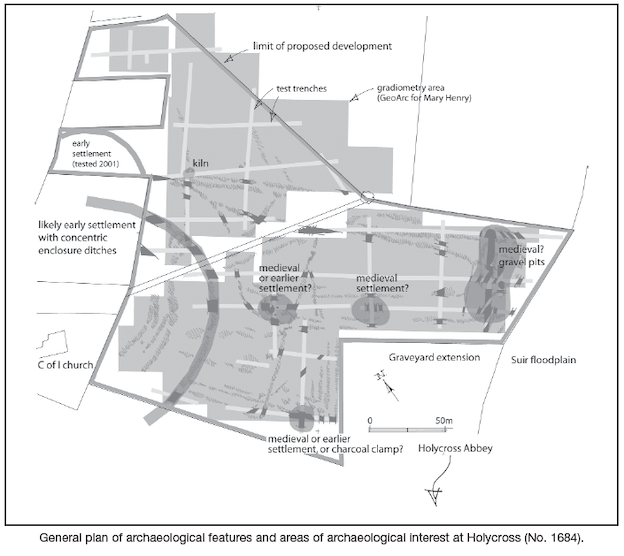
A low-density housing development has been proposed for land to the north of Holycross Abbey. The archaeological potential of the site had initially been assessed by geophysical survey (GeoArc Ltd surveying for Mary Henry Archaeological Services Ltd), and in September 2007 the site was further assessed by cutting 1800m of test-trenches.
Very little pottery was recovered from the development site during testing, and none was recovered from the trenches. No lithic tools or debris were found. The lack of finds is surprising for a large site so close to a medieval abbey. The absence of medieval pottery suggests this land was not heavily manured during the 13th/early 14th century, not gardens/orchards, and perhaps not fields. The ground may have been rough during the high medieval, with gravel pits to the east and charcoal burning in woodland to the south-west. The rectilinear enclosure pattern that has generally survived in surrounding field boundaries may be late medieval.
Most of the significant features, the straight and curved ditches, appear on the gradiometry survey. Testing enabled an assessment of the ground between, looking for surviving upcast bank material and indications of associated buildings. Several areas of archaeological interest were suggested.
The most prominent site was the enclosed hilltop around the Church of Ireland church. One of the concentric ditches was crossed by several trenches, and appeared to have traces of an internal upcast bank. No building remains were found between this ditch and one inside, or between this and one outside, to the north-east.
A scorched area in an exposed position outside the north-east arc of ditch appears to be some form of kiln, with no visible flue and no associated industrial waste (or lime). The feature is undated.
A low ridge of gravel at the east end of the site has been quarried. No datable material was found in the exposed fill, and no building remains. The gravel pit may be medieval.
Three areas towards the middle of the site produced likely settlement remains. The most northerly produced a likely pit, several likely post-holes, midden bone, a concentration of charcoal and possible stone paving. Strong magnetic disturbance in the area may represent industrial activity.
The eastern remains comprised a cluster of parallel ditches and another at right angles, some associated with charcoal and a considerable amount of midden bone. The bone is domestic waste from a dwelling in the near vicinity, probably within 10m of the intersecting trenches.
The southern remains comprise probable heavy stone paving (disturbed) in a shelf cut into gravel, some midden bone and a charcoal-rich ploughsoil (but no evidence of burning in situ). The gravel is coarse and does not appear to have been systematically quarried. The remains might be associated with a late prehistoric building or more recent (medieval?) charcoal preparation.