2006:1611 - NAVAN: Site 1, Navan Inner Relief Road, Moathill, Meath
County: Meath
Site name: NAVAN: Site 1, Navan Inner Relief Road, Moathill
Sites and Monuments Record No.: ME025–023
Licence number: 06E0274
Author: Antoine Giacometti, Arch-Tech Ltd.
Author/Organisation Address: 32 Fitzwilliam Place, Dublin 2
Site type: Historic town
Period/Dating: Multi-period
ITM: E 685882m, N 767769m
Latitude, Longitude (decimal degrees): 53.652636, -6.700853
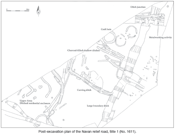
An excavation at Site 1, Navan inner relief road, Co. Meath, was conducted in the summer of 2006. The site was identified through a series of archaeological and geophysical assessments, as the proposed new road passed very close to Navan Moat. Three areas of archaeological interest were excavated in 2006 along Phase IIB of the Navan inner relief road. These were Site 1 (discussed here), located in the south-east corner of a field north-west of Navan Moat, and Sites 2 and 3 (excavated under Licence No. 06E0024 by Stuart Halliday, see No. 1612, Excavations 2006), located in a field to the west of Navan Motte. Site 1 comprised a settlement near the top of a small hill, and a lower-lying area of craftwork.
The settlement near the top of the hill
The excavation revealed a complex of archaeological features on the north-west-facing slope of a small hill that probably represent an enclosed settlement. The settlement was defined (and possibly defended) by a ditch to the east that followed a topographical line. A smaller ditch a few metres inside it, slightly higher up the hill, may have been contemporary with it and added to the impression of a clearly bounded and circular-shaped settlement when viewed from the lower parts of the hill. To the west, near the top of the hill, the features defining the settlement were much less clear and the boundaries were more fluid and less circular in shape.
The main entrance to the settlement was located to the south-east. It was clearly defined on one side by the terminus of the main ditch and on the other uphill side by a large pit that mimicked the shape of the ditch terminus. A feature in the entrance may have been a gate or similar entrance structure. Evidence for burning and a large amount of animal bone were found in the large pit forming the upper side of the entrance. This may have represented the reuse of the entrance feature later as a kiln or fire-pit, or else it may relate to a ritual or offering marking a particular time in the settlement’s history.
Inside the settlement enclosure five fire-pits, fire-pit dumps, occasional post-holes and part of a rectangular structure were found. No artefacts were found that might indicate a date for the enclosure. On the whole, the features indicate a residential settlement similar in size to a regular or small ringfort (i.e. able to hold a single extended family). The large quantity of animal bone found in this area contrasts markedly with the very limited amount of bone found in the lower-lying craftworking part of the site, and supports the interpretation of the enclosure being a residential settlement.
Marking boundaries
A large T-shaped ditch ran through the site and appeared to have marked an important boundary. From its shape, it might be supposed that three separate areas were being defined: one to the west of the ditch (being the area exposed in this excavation), one to the east of the ditch and one to the north. The ditch (or ditches) was in a continuous process of redefinition along its course, and it was the largest and most long-lived feature found on the site, both pre-dating the rest of the activity in its earliest incarnation and continuing in use after activity elsewhere ceased. The various phases of the ditch or ditches formed the basis for the phasing of the lower-lying part of the site.
The ditch is likely to have marked field boundaries during the earlier and latest phase of its use. During the time when the craftworking areas to the immediate west of the ditch were in use, however, the ditch appears to have provided an important drainage channel (and perhaps source of water) for the metallurgical, craftwork and processing taking place here, as well as marking a possible property boundary.
Evidence for two possible structures was found on the western side of the boundary ditch. These were very different from everything else on the site and their date and function was unclear. Of most interest about these features was that they respected the lines of the surrounding ditches, in particular the large boundary ditch, from which they were 4–5m distant. This distance would have allowed for, and is suggestive of, the presence of a large bank formed by excavated earth to the east of the ditch. It was also noted that later ditches often respected the line of infilled earlier ditches, suggesting these may have been marked above the ground in some way, such as by a bank, hedge or fence.
Craftworking at the base of the hill
Several distinct areas of craftworking were situated at the base of the hill and to the west of the large boundary ditch. From west to east, these were: (i) a long-lived curving ditch incorporating a fire-pit and water-management features; (ii) a series of intercutting linear drainage features; (iii) a cluster of three craft-huts, one of which replaced an earlier one; and (iv) a short-lived area of casual ironworking.
The most interesting feature was the ditch with a distinctive curve to the west. It seems to have been in use for a long period of time, spanning several minor phases of the larger boundary ditch into which it ran. Frequent evidence of maintenance and alterations found along its base demonstrated that it was well maintained. The burnt pit located at the west of the ditch contained numerous episodes of burning noted in the pit fills, which confirms that the pit was used over and over again and suggested that it was not constructed simply to enclose or for carrying water. The post-holes and deeper gully to the east of the ditch may have formed a structure such as a sluice, to manage and limit the flow of water through the ditch. No evidence for the purpose of the ditch was found, although it must have been used in a process involving both heat and water, perhaps cereal processing of some sort.
This ditch also contained the most interesting (if mixed) artefact assemblage, consisting of several fragments of post-medieval pottery, three tanged iron knives or knife blades and a bone pin. The pin and knives might suggest a broad early medieval date some time in the first millennium, and the post-medieval pottery may be intrusive; however, we will need the results of the radiocarbon dates to date the site with any certainty. For the moment, a broad early medieval (first millennium) date fits well with the evidence for the site as a whole, including the enclosed settlement at the top of the hill and the material found in Sites 2 and 3 further to the west.
Closing comments
The site has been fully excavated and no further on-site work is deemed necessary. Further analysis of the finds and samples from the site is ongoing. As this excavation was undertaken for the National Roads Authority, Project Archaeologist Mary Deevy was appointed to oversee the project and she was most helpful