2000:0702 - NEWTOWN–MONASTERBOICE (Site 3), Louth
County: Louth
Site name: NEWTOWN–MONASTERBOICE (Site 3)
Sites and Monuments Record No.: N/A
Licence number: 00E0796
Author: Cóilín Ó Drisceoil, for Valerie J. Keeley Ltd.
Author/Organisation Address: 6 Riverview, Ardnore, Kilkenny
Site type: Fulacht fia
Period/Dating: Prehistoric (12700 BC-AD 400)
ITM: E 705568m, N 780581m
Latitude, Longitude (decimal degrees): 53.764126, -6.398816
The site was found by Kieran Campbell during the monitoring of topsoil-stripping for the Northern Motorway (Drogheda Bypass). It lay beside a stream towards the top of a gentle south-facing slope, some 100m to the north of a fulacht fiadh at Newtown–Monasterboice 1 (Excavations 2000, No. 700).
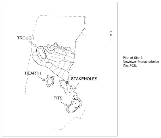
An area 16m x 8.5m was identified for excavation. An irregularly shaped, badly damaged deposit of burnt mound material (5.2m x 5.1m x 0.5m max. depth) covered a trough, two conjoined pits, a hearth and some 25 stake-holes.
The trough was rectangular (2.1m x 1.2m x 0.53m) and was dug into the boulder clay subsoil. It was filled with a number of distinct dumped fills. A large boulder was also contained within the lower fills on top of six irregularly split wooden planks. Ellen O’Carroll has identified the wood species as alder.
The hearth measured 1.5m x 1.1m x 0.25m. It contained a thick deposit of burnt stones, ash and burnt branches. Again, the wood species was alder. The two conjoined pits were filled with burnt mound material. Four stake-holes were found in the bottom of the pits. A further 21 stake-holes extended in an irregular fashion to the north. Flint debitage flakes were found in the burnt mound material and the fill of the hearth. Radiocarbon dates are awaited.