
County: Tyrone Site name: Eglish Wind Farm,Phase 2, Lettermuck, Eglish
Sites and Monuments Record No.: LDY 029:040 Licence number: AE/15/115
Author: Chris Long/ Gahan & Long Ltd
Site type: BA Urn Burial, undated pits /postholes, culvert
Period/Dating: —
ITM: E 650204m, N 904828m
Latitude, Longitude (decimal degrees): 54.888718, -7.217502
An archaeological evaluation was carried out prior to the proposed construction of a 6 turbine wind farm at Eglish, Co Derry. The proposed development lies within an area of archaeological interest, with one site, LDY 029:040 located within the development boundary. Phase 1 evaluation consisted of the monitoring of 48 trial pits under licence AE/14/163 where no evidence of archaeological deposits were uncovered. Phase 2 evaluation consisted of the monitoring of all ground penetrating works.
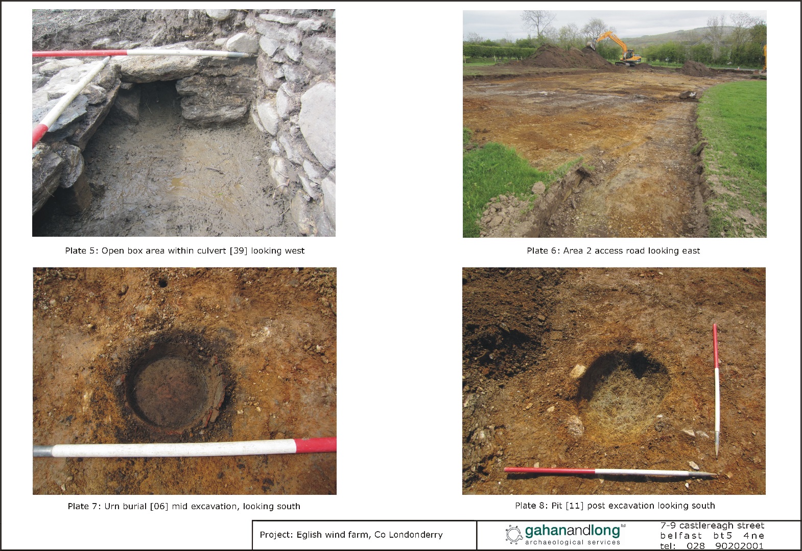
Ground reduction works were conducted using a back acting machine fitted with a toothless bucket and under strict archaeological supervision to the levels of naturally occurring subsoil or archaeological strata, whichever was highest. Monitoring of works for the creation of an access road from the Longland/Ballyarton Road junction to the site of the permanent construction compound uncovered several archaeological features: a 19th century culvert, a Bronze Age Urn Burial, a group of 3 pits and a posthole, 2 isolated postholes, an isolated pit and a curvilinear feature.
The culvert was located in a grass bank at the edge on the Ballyarton Road 38m NE of its junction with the Longland Road. It extended NW x SE for c. 5.4m and was 2.2m wide at the NW and 0.07m wide at the SE. It was not possible to determine the full extent of this feature as much of the W side of the structure has been robbed out. It consisted of: a ‘headwall’ , a series of capstones, a culvert walls and a support stone.
The pit, in which the Urn was placed centrally within, was located approximately 150m along the access road from the site entrance at Ballyarton Road. It measured 0.28m NW x SE x 0.3m NE x SW, had rounded corners and was sub-circular in plan. It had a sharp break of slope at the top and a moderate break of slope on the base at the NW. It had steeply sloped sides at the NW and gentle to moderately sloped sides at the SE. The base was concave and was excavated to a maximum depth of 0.13m but had been clearly truncated. Only the lower part of the urn remained, in fragmented form . The vessel was brown in colour and the fabric was quite coarse with flecks of mica present. The base of the vessel was c. 1cm thick while the side was 6-7mm thick. No decoration was visible on the urn. It contained a fill consisting of a moderately compact grey to black clayey silt with frequent inclusions of charcoal, burnt bone and a single flint flake. The remainder of the pit contained 2 fills. One consisted of a moderately compact greyish brown silty clay with occasional charcoal flecking and the other of a moderately compact charcoal rich black silt. Located 15 m W from the Urn Burial was a group of 3 pits and a posthole (undated). A further 4 archaeological isolated features were uncovered during the monitoring of the access road consisting of 2 postholes, a pit and a curvilinear feature.
No evidence of any archaeological deposits was identified during monitoring of the compound, of the main access road within the windfarm and of the hardstands and turbine bases 1-6.
7-9 Castlereagh Street, Belfast BT5 4NE


