
County: Armagh Site name: Killuney Park Armagh (South-west field)
Sites and Monuments Record No.: ARM 012:045 Licence number: AE/17/059
Author: Gavin Donaghy
Site type: Early medieval enclosure
Period/Dating: —
ITM: E 706423m, N 889274m
Latitude, Longitude (decimal degrees): 54.740219, -6.347273
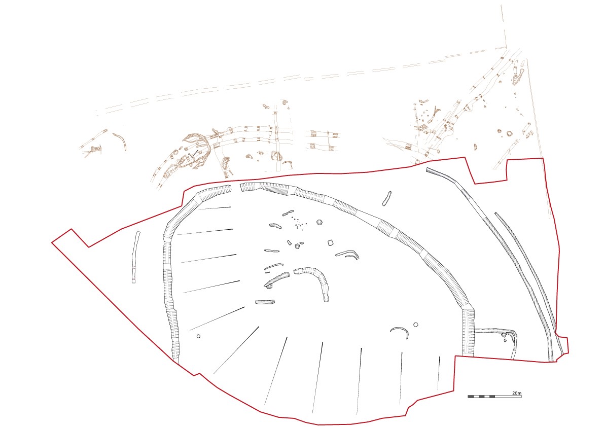
The proposed development area contained the remains of a very large settlement that had grown from its beginnings at the start of 6th century during the early medieval period growing in phases up until the medieval period in the latter half of the 14th century. This settlement was potentially occupied for 800 years and in that time the archaeology reflects the necessary expansion that would be required to support its occupants. The excavation site was the remains of a large multi-vallate early medieval enclosed settlement. The main settlement was a multivallate rath with a large ditch enclosing a hill to the north-east and west. The site sloped steeply towards the south where the natural boundary of a small water course determined the limit of the enclosure.
The internal diameter of the enclosure measured 113m with the majority of settlement activity on a raised naturally flat area at the north of the interior. Extending east and turning south, and branching off the main ditch at the south-east of the enclosure, was a small annex ditch which enclosed several small pits. Encircling the main ditch and annex to the west, north and east were two narrow ditches marking the potential limit of the settlement. The double ditches enclosed an area with an internal diameter of 150m. The remains of structures, ditches, pits and post-holes were located within the bounds of the large enclosure ditch. The highest concentration of features where cut into a large level area at the centre of the enclosure heading north towards internal edge of the ditch. Hazelnut shell from the enclosure ditch produced a date of AD528-622.
External to the main enclosure ditch at the south-east of the main ditch and cutting it, was an annex ditch. This ditch was much shallower than the main ditch running east initially then taking a sharp 90 degree turn to the south and heading outside the development area. There were several pits contained within the annex structure. A fill of the annex ditch was dated to AD662-774, indicating that its construction was part of a phased expansion to the existing settlement, possibly indicating the growth of either agricultural or industrial use within the settlement. The lignite ring discovered here may be indicative of the rise of crafting at the settlement. Encircling and respecting the main enclosure ditch and annex was a double ditch running south-east/north-west at the eastern side of the development area and a single ditch running south-west/north-east on the eastern side of the site. An earlier archaeological investigation (ADS 2008) revealed similar ditches to the north of the large enclosure ditch matching the trajectories of the double ditches discussed in this report.These ditches represent the last external phase of growth during the early medieval period and returned a date of AD662-774.
At the heart of the ditch complex, within the interior of the main enclosure ditch, was the remains of the possible settlement itself. The settlement comprised 9 potential structures in the form of truncated gullies. The earliest potential structure recorded within the main enclosure was a small curving gully to the south-east of the interior; the fill of this gully returned a date of AD532-638. The gully measured 11m long, 0.7m wide and had a depth of 0.45m.
At the centre of the main enclosure, running east to west and turning south at both termini, was a large ditch. This ditch may have enclosed something in antiquity but has been so heavily truncated as no evidence for internal features were uncovered within the bounds of the ditch. The ditch measured 35m long 1.7m wide with a depth of 0.7m, and contained several differing fills along its length; it became more shallow at its eastern and southern ends. The shallowing effect could have been due to its truncation but also that the ditch on its southern side continued and was cut into deep historic topsoil horizons. It is unclear what this ditch could have been enclosing but it may have been marking a boundary between what was in its interior and the rest of the settlement. This ditch contained much of the artefactual evidence for the centre of the enclosure, producing large amounts of very well-fired and decorated Souterrain ware and a very large lignite bead from its fills. The fill which produced the pottery within the ditch was dated to AD1020 - 1155, which makes it potentially one of the later additions to the settlement.
The settlement at Killuney park is substantial but the evidence for the industry that would have supported a settlement of this scale is small. One small potential furnace or kiln was noted outside of the annex structure at the south-east of the enclosure. Medieval pottery (Mid Ulster Coarse Ware) was discovered in small amounts in small features and gullies at the centre of the enclosure. This points to activity within the settlement at that time, however more compelling evidence for this was the discovery of a single large pit at the centre of the enclosure. Several of the fills contained large quantities of Mid Ulster Coarse Ware pottery, a basal layer containing this pottery was dated and returned a date of AD1347 – 1393. This is the latest date recorded on site and marks the potential end of activity on the site, with the next phase of activity noted being the cutting of a post-medieval field boundary that bisected the large internal ditch at the centre of the enclosure.
In conclusion the excavation of the site at Killuney Park uncovered a large multivallate settlement that began in the 6th century AD and finished at the end of the 14th century AD. The archaeological evidence showed the continued expansion of the site up until the 11th century after which the site may have started to go into decline. Fewer features were found from the later periods, possibly indicating a period of stagnation before the settlement's eventual declined.
Northern Archaeological Consultancy, 638 Springfield Road, Belfast


