2003:1448 - RANDALSTOWN, Meath
County: Meath
Site name: RANDALSTOWN
Sites and Monuments Record No.: N/A
Licence number: 03E0666
Author: Kieran Campbell
Author/Organisation Address: 6 St Ultan's, Laytown, Drogheda
Site type: Pit, Cremation pit, Burnt mound and Fulacht fia
Period/Dating: Prehistoric (12700 BC-AD 400)
ITM: E 684919m, N 771969m
Latitude, Longitude (decimal degrees): 53.690528, -6.714264
Monitoring took place over six weeks from 7 August to 15 September 2003 during topsoil-stripping associated with the vertical extension of the existing tailings facility at Randalstown (Stage 4B Tailings Dam Extension) by Tara Mines Ltd. During earlier stages of the tailings dam construction, from 1975 to 1999, a considerable amount of archaeological work was carried out by Eamonn P. Kelly, Cóilín Ó Drisceoil and the writer, in Randalstown and Simonstown townlands, as reported in previous issues of this publication (Excavations 1975–76, Nos 32 and 33; Excavations 1985, No. 44; Excavations 1986, No. 65; Excavations 1995, No. 234, 95E0232; Excavations 1998, No. 526, 98E0352). The present stage of the work concerned the remaining part, c. 100 acres, of the ‘Northern Borrow Area’, one of two borrow areas from which material for the raising of the walls of the tailings dam is obtained. In 1999, during monitoring of topsoil-stripping by Donald Murphy in the south-eastern part of the Northern Borrow Area (c. 25% of the total), a number of fulachta fiadh were excavated (Excavations 1999, No. 708, 98E0352 ext.).
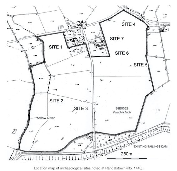
Most of the borrow area was stripped by a single Caterpillar D8 bulldozer, joined by a second D8 for the final two weeks of the work. Archaeological material was uncovered in seven areas, designated Sites 1–7.
Site 1, 28460 27270
Site 1 refers to 38 archaeological features/deposits exposed in a broad band running north to south up the centre of a seven-acre field. The features occurred singly and in groups and comprise mainly pits, 0.3–1.8m in size, with charcoal-flecked fills. A number of linear features, 2.6–4m long, may represent gullies or slot-trenches for structures. There is one probable cremation in a small pit, 0.3m in diameter, beside which a second pit produced a sherd of coarse prehistoric pottery. Three features contain burnt-mound-type fill.
Site 2, 28458 27235
Site 2 is located on the summit and northern slope of a low rise, indicated by the 50m contour on the OS Discovery Series map. The site consists of four features, probably pits. F2 measures 0.75m by 0.6m, with burnt-mound-type fill; Nos 3–5 are small subcircular pits, 0.3–0.5m in diameter, within 6m of each other. The fill of one pit contains burnt bone. F1 was a recent sheep burial.
Site 3, 28476 27234
The site consists of a fulacht fiadh in a low-lying area beside a stream, with an additional four small archaeological deposits/features located c. 16–20m upslope on a low rise to the south. The fulacht fiadh presents as an intermittent thin spread of burnt stone in dark soil, 23m east-west by 10m, which continues north into an unstripped zone under ESB lines. A further burnt-mound deposit, measuring up to 6m by 1.2m, is situated 38m to the south-east of the fulacht fiadh. This site lies in a westward extension of the area of low-lying ground where Donal Murphy previously recorded a number of fulachta fiadh in 1999 (Excavations 1999, loc. cit.).
Site 4, 28505 27287
The site comprises three areas, designated Areas A–C. In Area A, at least eleven features/deposits are located in a c. 10m by 10m area on the summit of a ridge. One deposit, 0.75m in diameter, contains burnt bone. The outline of others is unclear, due to the similar texture of the fills and subsoil. It is possible that some of the deposits are part of a single larger feature, possibly linear. Area B, c. 10m by 10m, is 25m downslope to the south of Area A and contains a 1.8m by 2.5m deposit of burnt stones with other less distinct deposits in the immediate vicinity. In Area C, 26m to the south-east of Area A, a gully aligned north-east/south-west is traceable for a distance of at least 6m. It has a V-shaped profile, 0.6m wide and 0.4m deep, with a charcoal-flecked fill.
Site 5, 28517 27263
Site 5 is located at the eastern margin of the Borrow Area and is likely to continue under the topsoil berm. At least eleven deposits or features are present, which are arranged in a 26m by 12m arc. Some deposits are clearly the fills of small pits, 0.3–0.8m in diameter, but others, especially those to the south, are less clear and appear to be linear. All fills have charcoal inclusions; there are occasional burnt stones and oxidised soil. A flint scraper and a medieval plough pebble were found on the topsoil berm following stripping of the site.
Site 6, 28497 27269
Site 6 is a fulacht fiadh located in a wet hollow c. 300m north of the four fulachta fiadh excavated by Donald Murphy at the south end of the field in 1999. The site consists of a 14m by 10m spread of burnt stones in dark-grey charcoal-stained silt which does not appear to exceed 0.2m in thickness. Some topsoil was left in situ over the burnt spread to prevent it from drying out. Twelve metres to the north-east, there is an isolated deposit, 2m in diameter, of grey silt with burnt stone.
Site 7, 28492 27280
Site 7 covers two groups of deposits or pits, 31m apart, situated 175m upslope from Site 6. Area A consists of two deposits of burnt stone and dark soil, 1.7m apart. The deposits have maximum dimensions of 0.4m and 0.8m. Area B has five features, 0.2–0.65m in diameter, in an apparent circular arrangement around an oval deposit, 1.5m by 1m, of dark soil with charcoal, in which one piece of burnt bone was noted. The putative circle has a diameter of 7m. Further deposits may be present under the loose topsoil/overburden in this area.
Conclusions
This density of material mirrors that found in the Simonstown Borrow Area by Ó Drisceoil in 1998 and in the south-east of the Randalstown Borrow Area by Murphy in 1999. In a broader context, the discoveries are consistent with the findings in other projects in counties Meath and Louth where large-scale topsoil-stripping has taken place. The sites at Randalstown all appear to be of prehistoric date. Two sites, Nos 3 and 6, may be classified as ‘burnt mounds’ or fulachta fiadh. The other sites are characterised by pits, often of small size, which, without excavation, are not classifiable. However, a prehistoric date may be assumed from the presence on all seven sites of deposits containing burnt stone. Comminuted burnt bone, possibly representing cremations, was present in deposits on four sites, Nos 1, 2, 4 and 7. One sherd of coarse prehistoric pottery was recovered from a pit on Site 1. The absence of flint was noticeable, both from the archaeological deposits themselves, although disturbance was minimal, and as stray finds or naturally occurring flint in the topsoil. The single piece of flint recovered was the flint scraper found in the topsoil from Site 5. The topsoil contained pottery of 19th/20th-century date, with no medieval or early post-medieval finds.
None of the seven sites uncovered has been excavated, but all have been cordoned off and the deposits reburied under geotextile and topsoil. At the time of writing, no final decision has been taken on whether to excavate the sites or preserve the material in situ. It is likely that certain sites (e.g. Sites 3 and 5) will be excluded from the development area.