
County: Wexford Site name: GLASCARRIG NORTH
Sites and Monuments Record No.: SMR 17:10 Licence number: 99E0107
Author: Cóilín Ó Drisceoil
Site type: Excavation - miscellaneous
Period/Dating: Multi-period
ITM: E 721474m, N 649364m
Latitude, Longitude (decimal degrees): 52.581985, -6.207518
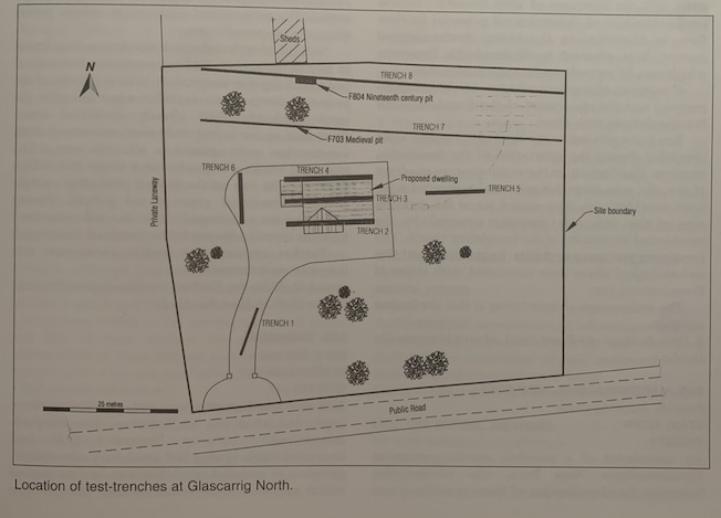
An archaeological assessment of a residential development adjacent to Glascarrig Priory included the excavation of test-trenches in the area of the development.
Monks from the order of St Tiron founded St Mary's Priory at Glascarrig in c. 1190. Glascarrig was the only Irish priory of the monks of St Tiron, although little is known about the history of the Priory. It is known that it held many lands and benefices in County Wexford. The Priory was suppressed in 1543, and in 1560 the remains are described as comprising a cell, a church, a hall, two rooms, a chantry and a small yard. The south wall of the church survives, and some of the foundations of the Priory church can be traced in the ground, forming a rectangular building. The east and part of the north wall are built into a residential house, and the western part of this building is shown on the first edition OS map.
The development site was 20m south of the church, in a ploughed field. Eight test-trenches were excavated mechanically. Nothing of archaeological interest was found in Trenches 1–6.
Trench 7 was excavated along the north of the site. The topsoil here was 0.5–0.6m deep and overlay light brown marl throughout most of the trench. Near the west end of the trench a subcircular refuse pit of medieval date was uncovered. The pit measured 1.4m x 1.1m and was cut into the marl. The fill was a compact, sticky, light grey, silty clay of moderate stoniness with frequent inclusions of charcoal and animal bone. Four sherds of late 12th-13th-century pottery were recovered from the surface of the fill.
Trench 8 was parallel to Trench 7. The topsoil was 0.1–0.5m deep and overlay a sterile sand that was 0.5m deep and overlay the light brown marl. Near the west end of the trench a cobbled surface was found sealing a large, 19th-century refuse pit. The pit cut through marl and was subcircular with vertical sides. It was 1.3m deep and 4.05m wide. It was exposed for 2m, but its full length north-south was not ascertained. The fill of the pit was a wet, soft, grey/black, silty sand with frequent large, angular stones. There were frequent inclusions of red brick, leather off-cuts and 19th-century pottery. The fill also contained a large amount of animal bone, including the incomplete skeleton of a horse.
The development had no impact on either refuse pit, and no further archaeological work was recommended.
6 Riverview, Ardnore, Kilkenny


