2006:1471 - SLIEVEMORE, Achill, Mayo
County: Mayo
Site name: SLIEVEMORE, Achill
Sites and Monuments Record No.: N/A
Licence number: 06E0428
Author: Simon Ó Faoláin
Site type: Settlement cluster
Period/Dating: Multi-period
ITM: E 463230m, N 807311m
Latitude, Longitude (decimal degrees): 53.996919, -10.086031
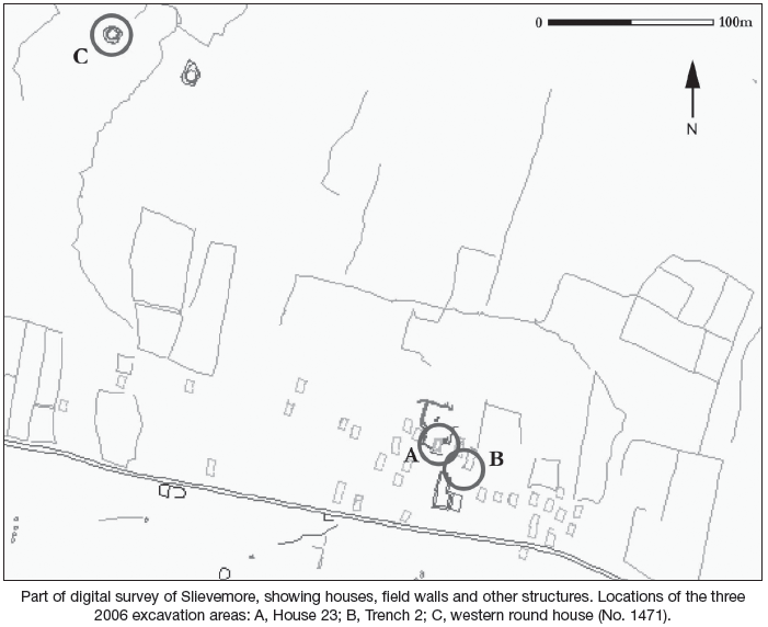
Work in the 2006 season at Slievemore took place at three different areas, which are not linked stratigraphically and are each considered independently from one another: Area A, House 23: a post-medieval house and environs; Area B, Trench 2: a post-medieval roadway and undated semi-subterranean orthostatic structure; Area C, undated round house: exploratory test-trenching.
Areas A and B above are ongoing excavations following on from work directed by Audrey Horning (Excavations 2004, No. 1154, 91E0047; Excavations 2005, No. 1133, 05E0599) and Theresa McDonald (1992–2003, Excavations 2003, No. 1342, passim). These two areas are close to each other, lying only c. 20m apart. Area C, on the other hand, had not previously been subject to intrusive work and the excavation here in 2006 was confined to a series of test-trenches.
Area A: excavations at House 23 and environs
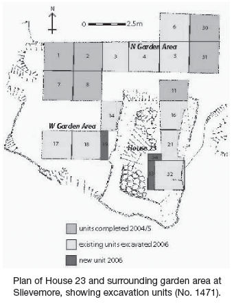
House 23 is a single-unit dwelling situated within the westernmost village on the slopes of Slievemore, measuring 20.6 feet in length by 10.6 feet. Architectural features that can still be discerned include: opposing east–west doorways, the west doorway being blocked; a single window situated in the northern half of the west wall; a manure pit outside the eastern door; and, unusually for the houses on Slievemore, evidence for corbelled construction in the rounded south-west corner of the structure. With the exception of several sherds of North Devon coarse earthenware (gravel-tempered and plain), an English utilitarian ceramic dating to the 17th and very early 18th centuries, all materials excavated in the garden area of House 23 date to the 19th through early 20th centuries.
Investigations within the house had several interesting aspects from the previous season’s work to consider. These included the existence of a built hearth and stone bench against the north gable, both features not commonly encountered in Slievemore, and an internal drain running pretty much the full length of the house interior. The hearth and related contexts were the main focus of excavation in the north end of the house interior. A number of ash-based deposits were removed from the hearth, as well as two structural deposits of hearthstones.
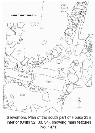
In the south-east corner of the house, work was undertaken to complete the excavation of the north–south-running stone-lined drain, part of which had been removed in the 2005 season. Elsewhere in the south part of the house, a small section was cut in an unclear area, where it was believed two sections of a stone-lined drain with different alignments would meet. This demonstrated that the two do join up, although this does not necessarily mean that the two parts of the drain were contemporary.
Excavations elsewhere within the house were confined to the area to the south of the house’s east doorway. This area is raised above the surrounding floor level and is at present defined by an east–west-running arrangement of stones, C505, which is a drain probably relating to the use of the south end of the house as a byre.
To the north of the drain/revetment was another deposit of medium to large stones, C742, which included two flat rocks running roughly parallel to drain/revetment C505. C742 is therefore thought likely to form part of the north side of a large east–west-running drain, the south side of which would be C505.
To the south of the drain/revetment lay C687, a roughly linear deposit of some nine or so medium to large stones lying to the south of and up against C505. Several other deposits were excavated in this area and mainly seem to consist of redeposited soils used to raise the surface here. Excavation of these deposits revealed C686, a roughly rectangular structured arrangement of medium-sized rocks abutting the inner side of the east wall. This context is interpreted as a stand or base for some structural member, perhaps a roof support or an upright for a half-loft.
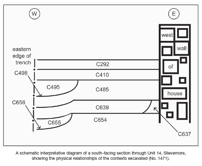
Work in the west garden area took place mainly in the area immediately adjacent to the wall of House 23. The uppermost context under excavation in 2006 was dark-grey sandy loam, which filled a linear north–south-running cut, C498. The latter trench had been cut into a probable cultivation layer, C485, which covered the full extent of the unit in plan.
Several more cultivation layers and the cut of a lower north–south-running lazy bed were also uncovered in this area.
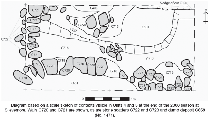
As in previous seasons, the emphasis in the north garden area was on attempting to understand the uncovered contexts as they related to the probable alteration of House 23. Architectural evidence suggests that House 23 had originally possessed a northern section that was abandoned at some stage, the house being foreshortened and the north gable moved southwards.
In 2006 the foundation of the original north house-end was uncovered, C720, bonded with red soil C718. An adjacent external retaining wall, C721, was also uncovered, as was C723, a deposit of stone scatter resulting from tumble from C720.
In the north-east corner of the area was C658, a discrete dump deposit consisting of rocks mixed with a silty sand, possibly related to agricultural clearance or construction activity. Several deposits of silt lie to the north of house wall C720 but have not yet been excavated.
The only finds recovered in the north garden area in 2006 were a piece of olive-green glass from C396 and a piece of stone from cleaning the surface of C501, which appears to be very rich in a blue ore, possibly malachite.
Area B: excavations at Trench 2
Excavations in Trench 2 were a continuation of previous work at this location and focused on two different areas, B1 and B2.
In B1, an extension (2m north–south by 2m) was added on to the east end of Cutting F, directly to the south of House 25 at the east end of Trench 2, to investigate in detail the post-medieval roadway running through the village and any underlying deposits.
(B1) Excavation of the roadway and associated contexts
Excavations in Cutting F were intended to glean further information on the nature of the post-medieval roadway and its possible relationship with House 25.
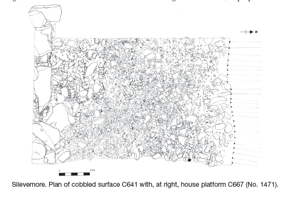
In B1, an extension (2m north–south by 2m) was added on to the east end of Cutting F, directly to the south of House 25 at the east end of Trench 2, to investigate in detail the post-medieval roadway running through the village and any underlying deposits. Removal of the thin topsoil immediately revealed two contexts. C662 was a stone platform composed of large, roughly shaped boulders supporting the southern gable of House 25. Abutting the south face of this gable platform and appearing to pre-date it was C641, a densely packed cobbled surface composed of water-rolled cobbles. Many of the stones had been split longitudinally and placed with their smoothed surfaces facing upwards. Numerous fragments of glass, ceramics and iron were recovered from between the cobbles, apparently having been dropped and trodden into the surface. Along the south of the cutting edge were three stony contexts forming the roadway embankment, running east–west.
For the most part, the cobbling lay upon C625, a very hard layer of grey sand into which the cobbling seems to have been driven to form the road surface. Below C625 and roughly coterminous with it was C633, a layer of very fine, pure yellowish-brown sand that covered the entire area of the east extension of Cutting F. This sand, which is some 0.24m thick, is remarkable for the almost complete absence of any inclusions within it, stone, shell or otherwise. It seems likely that it was deliberately laid as part of the road-construction process, but where it was sourced is unknown.
C633 was separated from a lower, narrower cobbled roadway, C688, by several layers of silt. Next to this was C689, interpreted as a deposit deliberately built up on the latter slope in order to make a level platform for the construction of the upper cobbled roadway. Quite waterlogged, C689 yielded a number of finds, including a small rectangular piece of worked wood, pieces of possibly worked quartz and carbonised grain.
The relative narrowness of C688 (0.85m) in comparison to C641 (2.3m) is notable, and it is questionable whether C688 was intended for wheeled transport, as the upper layer of cobbling probably was.
Underlying C688 was C691, a hard, mottled reddish-brown/grey layer of sandy silt. Originally thought to be natural subsoil, the fact that it turned out to be a quite thin layer, with further contexts beneath, led to reinterpretation as redeposited subsoil. It may have been deliberately laid as a base for cobbling C688. A number of silt deposits of possibly natural origin were the lowest level reached here this season.
(B2) Excavation at the semi-subterranean orthostatic structure
Work was continued in the area to the rear of the semi-subterranean orthostatic structure at the west end of Trench 2. While this had been under investigation since 1998, its purpose and date remain in doubt. In 2005 attempts commenced to find a building cut into which the structure had been placed, with the aim of establishing a date for the structure. During the course of previous excavations south and west of House 25, an orthostatic feature with a curvilinear passage and a roofed chamber was unearthed. Suggested explanations for this feature have included an early medieval souterrain, an unclassified megalithic tomb and a cereal-drying kiln. Excavations in the 2006 season were confined to the area at the rear (north) of the chamber. Initial cleaning of the area recovered a sherd of 17th- or early 18th-century North Devon ware, a round, perforated blue glass bead of undetermined date and a small prehistoric-type concave flint scraper.
Stratigraphy at the chamber rear was difficult to differentiate and mostly consisted of slightly differing layers of sterile sand and gravel, which appeared to have been naturally deposited. However, several contexts encountered are considered likely to be related to the construction or ongoing use of the chamber, due mainly to their apparent use as capping/sealant between the capstones. These are C649, C666 and C702. Two other deposits, C694 and C703, are considered possibly archaeological on the basis of artefacts (possible pottery fragment) and ecofacts (carbonised grain) respectively.
To sum up, only those contexts actually sealing the capstones can be confidently regarded as resulting from deliberate human agency, the rest being possibly or certainly of natural origin.
(C) Test excavation at the western round house
The site is the more westerly of two undated round houses on the slopes above the deserted village. These lie some 300m to the north-west of the House 23/Trench 2 excavations at an approximate height of 150m OD. The two round houses are separated by a gap of 50m, with an undated curvilinear field boundary running between them.
The western round house measures 12.5m east–west by 11.1m externally and 8.15m east–west by 7m internally. It appears that during construction earth was dug out of the hillside and cast downslope to form a level platform. The north, upslope, side of the hut wall is only c. 0.35m above the surrounding ground surface, while the downslope wall, due to the construction of the level platform, is c. 1.3m above the external ground surface. Construction, insofar as can be told from its current condition, was of drystone walling. There is an entrance facing east-south-east which appears relatively complex, including as it does three or possibly four surviving upright portal stones, one pair on the exterior and one on the interior. Between these there is evidence to suggest that the sides of the doorway were faced with stone. The distance between the outer and inner portal stones—some 2m—may give some idea of the original thickness of the wall, at this point at least.
Excavations were restricted to three small test-trenches. Trenches 1 and 2 were positioned outside the structure, both at a distance of c. 5m from the round house wall remains and both measuring 1m square. Trench 1 lay directly to the east of the doorway, Trench 2 was positioned to the north of the house in an area of high phosphate levels and Trench 3 was positioned within the interior of the house. It measured 2m by 1m, with its long axis aligned roughly north–south.
Despite differences in stratigraphy, the overall picture presented by the two external cuttings is similar. This indicates periods of unrestrained peat growth interspersed with episodes where layers of quite sterile-looking sand or silt built up. The overall impression is that little or no cultivation took place throughout most of the time represented by the excavated strata. The only possible exception to this is the bottommost layer in both trenches. These layers of dark-brown sandy silt were interpreted as probable cultivation soil.
Although Trenches 1 and 2 were positioned partially in order to investigate exceptionally high phosphate levels in these areas identified through previous analysis, nothing that could be interpreted as organic material relating to such high levels was encountered during the excavation.
In Trench 3, two thick layers of peaty silt that contained high levels of organic material (C700 and C726) are thought to contain a large proportion of animal manure, probably resulting from the use of the round house for holding cattle subsequent to its abandonment and partial destruction. Historical information supports this interpretation, with the round house recorded as having been used as a pen for impounding stray cattle during the 19th century. The lower of the latter two probably 19th-century layers, C726, lies directly upon black silty sand, C733, with a mixed interface between them. This need not suggest that the two are closely related in time; however, the presence of cattle within the round house would inevitably have led to severe churning of the soil and may have removed much of the stratigraphy which pre-dated this reuse. It is therefore possible that a considerable period of time separates C726 and the underlying C733.
C733 has been interpreted as an occupation layer on the basis of the widespread presence of charcoal within it and the fourteen stone artefacts recovered from it, although none of these can be considered to be datable on initial inspection. The five cut features in the south-east quadrant of the trench—interpreted as a post-hole and several stake-holes—probably constitute part of a structure, forming as they do a rough arc from north through west to south.
Artefacts
A total of 1225 finds were recovered between the three excavation areas at Slievemore in the 2006 season. Of these, 965 were from House 23 and environs, 244 from Trench 2 and 16 from the test excavations at the round house. The majority of finds at the former two areas consisted of late post-medieval pottery and glass fragments, while pieces of possibly worked quartz were recovered in moderate amounts in all areas and made up the bulk of the artefacts from the round house. Other finds of interest were a flint thumbnail scraper of prehistoric type, a blue glass bead and a sherd of North Devon ware (17th/18th-century), all from Trench 2, and several pieces of flint debitage from the round house. Ecological remains are undergoing analysis and a 14C date is pending for charcoal recovered from an occupation surface within the round house.
