1999:797 - KNOCKNAREA MOUNTAIN, Sligo
County: Sligo
Site name: KNOCKNAREA MOUNTAIN
Sites and Monuments Record No.: N/A
Licence number: E000998
Author: Stefan Bergh
Site type: Excavation - miscellaneous
Period/Dating: Prehistoric (12700 BC-AD 400)
ITM: E 566993m, N 836395m
Latitude, Longitude (decimal degrees): 54.275291, -8.506775
The Knocknarea Archaeological Project is a two-year project (1999–2000) focusing on the characteristic mountain of Knocknarea, Co. Sligo. The main aim of the project is to expand our interpretation of the role of this mountain in the symbolic and physical world of Neolithic Cúil Irra.
The project involves extensive fieldwork, including a field-walking programme, field survey, trial excavations and geophysical and digital surveys of the prehistoric sites and the topography of the mountain. The main funding of the project comes from the Swedish Foundation for International Co-operation in Research and Higher Education. The geophysical and digital surveys have been funded by the Heritage Council, while the trial excavations have been funded by Dúchas.
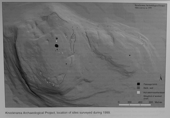
To understand the mountain and its prehistoric remains, a very detailed field-walking programme was undertaken. One of the main aims was to record Neolithic activity on the mountain, represented by the occurrence of worked lithics. Another aim was to achieve an updated record of the prehistoric sites on the mountain.
The survey falls spatially into two different areas: the lower, eastern ridge and the higher ground to the west, with the well-known group of passage tombs on the flat top. Unfortunately, the major part of the lower, eastern ridge is covered by very dense forestry. This has made field-walking in some areas impossible, which of course has had a negative effect on the result. Nevertheless, nearly forty locations with worked chert have been registered within this ridge, indicating that this hitherto neglected area was once the site of extensive activity during the Neolithic.
Besides the finds of lithics on the eastern ridge, a hut site was recorded on the lower part of its northern slope. The fact that only one previously unrecorded site was noted within the eastern ridge is a result of the very dense and insensitive forestation that has been allowed to develop here.
The field-walking and the survey carried out within the higher part of the mountain resulted in an unexpectedly high number of previously unrecorded sites. The survey has so far recorded 25 hut sites/hut features, four low cairns/stone spreads, four house? foundations, one kidney-shaped earthen mound and c. 2.3km of banks and walls forming an extensive system on the eastern side of the mountain. The well-known group of passage tombs on the flat summit remained, however, unaltered regarding number and location.