1999:796 - KNOCKNAREA MOUNTAIN, Sligo
County: Sligo
Site name: KNOCKNAREA MOUNTAIN
Sites and Monuments Record No.: N/A
Licence number: 99E0483
Author: Stefan Bergh
Site type: Hut site and Enclosure
Period/Dating: Prehistoric (12700 BC-AD 400)
ITM: E 566993m, N 836395m
Latitude, Longitude (decimal degrees): 54.275291, -8.506775
The Knocknarea Archaeological Project is a two-year project (1999–2000) focusing on the characteristic mountain of Knocknarea, Co. Sligo. The main aim of the project is to expand our interpretation of the role of this mountain in the symbolic and physical world of Neolithic Cúil Irra.
The project involves extensive fieldwork, including a field-walking programme, field survey, trial excavations and geophysical survey, as well as digital survey of the prehistoric sites and the topography of the mountain. The main funding of the project comes from the Swedish Foundation for International Co-operation in Research and Higher Education. The geophysical and digital surveys have been funded by the Heritage Council, while the trial excavations have been funded by Dúchas.
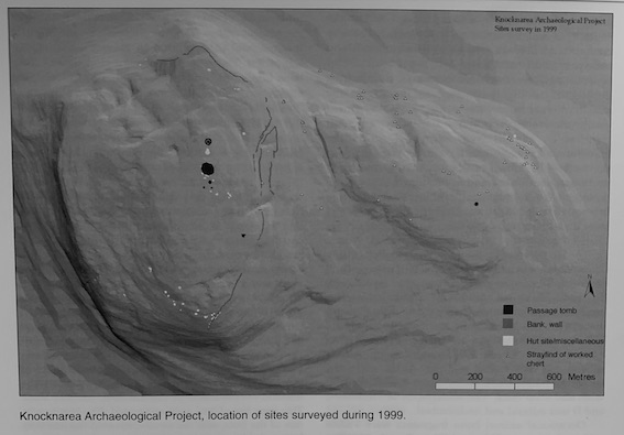
On the southern part of the mountain a few hut-like features had been noted on aerial photographs. Some of these hut sites, which were recorded during field-walking, were in many ways identical to those excavated on the north-eastern side of the mountain. During the survey 21 hut sites or hut-like features were recorded in this area. Just east of this group of huts, at c. 240m above sea level, a substantial wall that followed the contour east of the huts and then cut diagonally down the hillside to the south, was noted. The occurrence of hut sites and a wall in the southern area made an obvious parallel to what had been noted in the northern area. As nothing was known about the date and context of this hitherto unrecorded complex, a limited excavation was considered highly important to the further analysis and interpretation of the mountain and its prehistory.
The main aim of the excavation in the southern area was to establish the cultural context of one of the hut sites. A second aim was to establish the relation between one of the hut sites and the wall. Two trenches of 3m2 were excavated. The first was in one of the huts, and the second covered the junction between a hut and the wall.
The hut had an overall diameter of c. 12m, and consists of a circular low wall of limestone slabs and smaller stones. There was an entrance at the north-east.
Finds from inside the hut consist of different chert and flint artefacts, as well as debris from tool production. The artefacts were dominated by different types of concave scrapers.
As the finds and construction recorded were identical to the excavated huts in the northern area, a Neolithic date also seems likely for this southern hut site.
The hut adjacent to the wall had an overall diameter of c. 12m and consisted of a low, semicircular wall, with both ends adjoining the long wall recorded.
Finds from inside the hut included different chert and flint artefacts (mainly concave scrapers), as well as debris from tool production. Stratigraphically, the finds were restricted to a single cultural layer in the hut and the uppermost part of the wall.
The finds were identical to those recorded in the nearby hut and in the hut sites in the northern area, again indicating a Neolithic date. The wall was c. 0.8m high and c. 4m wide and consisted mainly of different-sized stones. The upper part consisted of smaller stones, while the lower part consisted of larger, limestone slabs. No finds were made in the wall. The finds recorded in the uppermost layer of the wall give a terminus ante quem for the construction of the wall, indicating that it had been present during the use of Hut site B.
The preliminary interpretation is that the huts in the southern area represent an activity similar to that recorded in the northern area. The 21 hut sites or hut-like features recorded in the southern area may, however, indicate that this area was more intensively used than the northern. The two areas are linked by the large wall/bank, and it should be noted that all the huts are on the uphill side of this large enclosure, cutting off the mountain to the east. The activity represented by the huts was clearly restricted to the upper part of the mountain, and it is reasonable to assume that this activity was in some respect linked to the ritual monuments on the very summit, dominated by the well-known cairn of Miosgán Meadhbha.