1999:323 - BALLYWIHEEN, Kerry
County: Kerry
Site name: BALLYWIHEEN
Sites and Monuments Record No.: SMR 42:94
Licence number: 98E0371
Author: Margaret McCarthy, Department of Archaeology, University College Cork
Site type: Ecclesiastical enclosure, Children
Period/Dating: Multi-period
ITM: E 435185m, N 603555m
Latitude, Longitude (decimal degrees): 52.159205, -10.408973
A second season of excavation was undertaken at Ballywiheen from August to September 1999. The monastic site is known locally as An Raingiléis, which means ‘the site of or ruins of an ancient church’. The site was also used as a calluragh, and unbaptised children were buried here within living memory. Archaeological investigation was initially required at Ballywiheen in 1998 following the insertion of a well shaft immediately outside the eastern circuit of the enclosing wall. A number of archaeological deposits and features were uncovered during that season, including a backfilled souterrain and the foundation of a wall (Excavations 1998, 89). These were interpreted as being contemporary with the primary use of the monastic enclosure. A later phase of activity was represented by the partial remains of a human burial.
Excavation was necessitated again in 1999 when archaeological monitoring along the line of a pipe-trench extending from the well shaft to the public road led to the discovery of a burial site. The excavation was originally limited to the area of the pipe-trench, but when it became apparent that significant archaeological deposits were present Dúchas requested that the full extent of the monument be exposed and excavated. The site is beside the road, c. 60m south-east of the monastic enclosure. A modern field boundary bisects the site north-south, and the monument narrowly survived the construction of the road in the early 19th century. The quadrant in the adjacent field lay outside the area of development and was therefore not excavated.
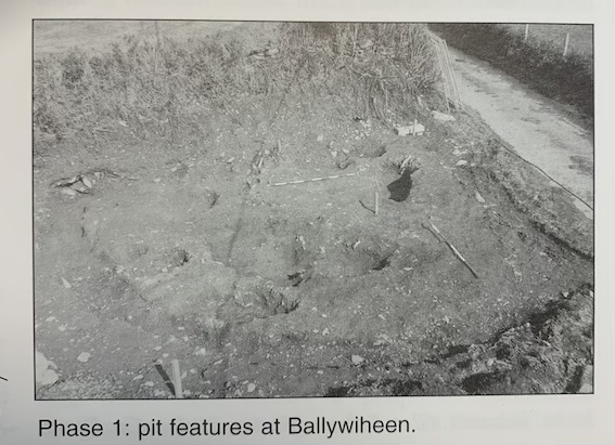
Two phases of activity were discerned. The earlier was represented by a series of pits cut into the natural boulder clay. These varied considerably in size and depth, from over 1m long and 0.65m deep to less than 0.35m in diameter. These smaller pits contained relatively large amounts of charcoal. Bulk soil samples were processed under laboratory conditions for material finds and bones, but, apart from three tiny fragments of calcined bone found in one pit, nothing was recovered. It was not possible to determine whether these bones were human or animal. In the absence of material finds and organic material, the function of the pits remains uncertain. The larger pits may possibly have held crouched inhumations, but no human remains were found to confirm this. The acidic soil conditions prevailing at the site may have resulted in the complete disintegration of the skeletons. Dating of this phase of activity will rely on radiocarbon analysis, and charcoal samples have been submitted to the laboratory in Gronigen.
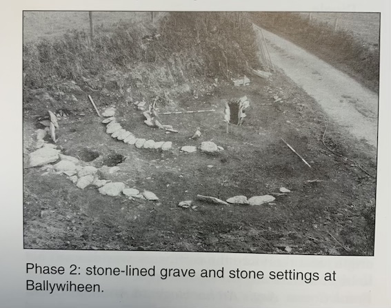
The second phase of activity saw the insertion of a lintelled grave surrounded by three semicircular stone settings. The inner and outer settings were placed upright in a shallow trench, and the central setting overlay two of the pits associated with the earlier phase of activity. The stone settings were covered by a thin layer of cairn material, which also sealed the earlier pits. The lintelled grave was revealed when the road boundary was removed to create an entranceway into the site. The seven covering slabs survived the construction of the boundary fence and the public road. Excavation revealed a rectangular grave aligned north-west/south-east, carefully constructed of locally derived shale slabs that formed the sides and lintels. There were no flooring or end stones. The grave measured 2.2m by 0.64m and was 0.52m deep. No burial survived, but the acidic soil conditions may have mitigated against organic survival.
Material finds were scarce but included a hone stone, a spud stone and a loom or net weight. All were recovered from the layer of cairn material. The few artefacts found and the proximity of the burial site to the monastic enclosure point to an early medieval date for the construction of the monument, but the possibility of an earlier origin for the phase of pit digging should not be discounted. Charcoal samples from both phases have been submitted for radiocarbon analysis. The results of the excavation are currently being prepared for publication.


