
County: Galway Site name: Caherconnell cashel
Sites and Monuments Record No.: CL009-03010 Licence number: 10E0087
Author: Michelle Comber, Caherconnell Archaeology Field School
Site type: Early Medieval and Medieval cashel
Period/Dating: —
ITM: E 523589m, N 699520m
Latitude, Longitude (decimal degrees): 53.040911, -9.139686
Caherconnell cashel is the largest of four drystone enclosures in the townland of the same name, in the Burren, Co. Clare. The cashel is circular with a diameter of 42m. It is defined by drystone walls standing 3m in basal width and 3m in height (though they were probably higher originally). Its entrance, like that of most ringforts, faces east.
Today, the interior of the cashel is, on average, 0.75m above external ground level. A small number of features protrude above the modern grassy surface. These include a collapsed drystone wall that divides the interior in two, the lower courses of an irregular-shaped stone structure built up against the inner face of the cashel on the west, and the lower stone courses of a rectangular structure built inside the cashel wall on the north (2015 focus). An international field school has been established to undertake research excavation of the cashel.
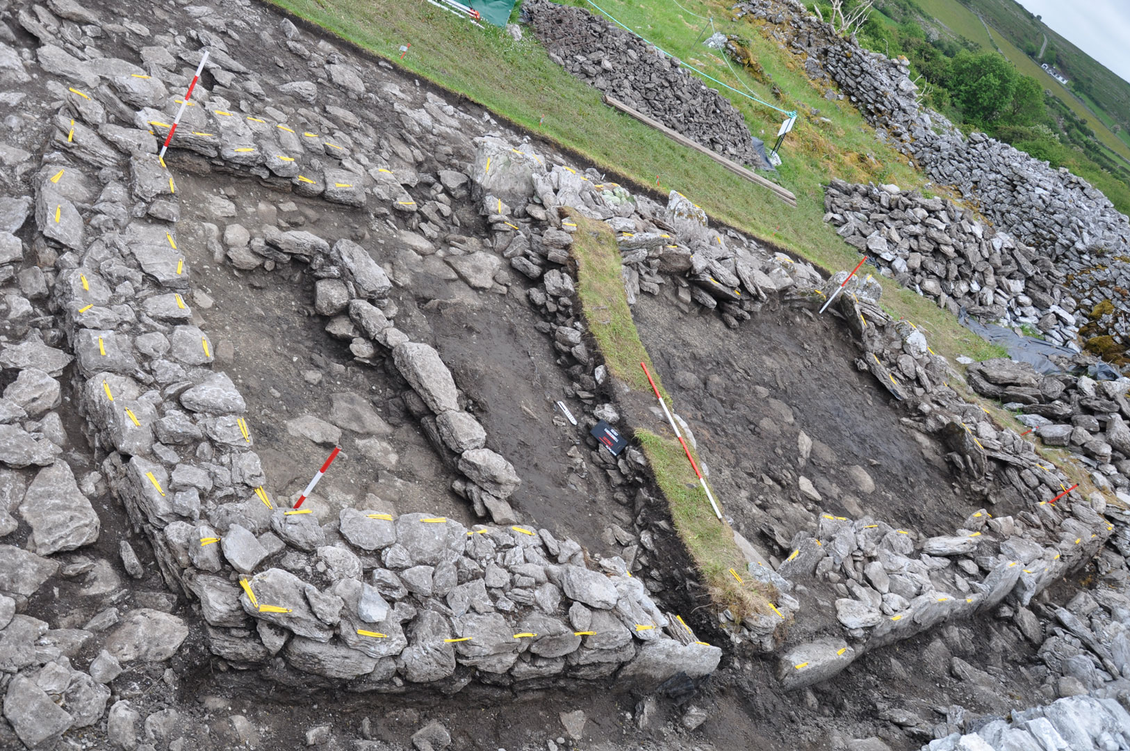
2015 Cutting F
The 2015 Caherconnell Archaeological Field School excavations concentrated on an area just inside the north wall of the cashel, immediately north of the 2014 cutting (Cutting E). This work identified several phases of activity, some associated with deliberately laid slab surfaces, houses, pathways and other features. Artefacts were numerous this season, including iron pins, tools, knives, nails, arrowhead, key, shears, bronze pins, dress loops, sewing needle, bone combs, dress pins, spindle whorl, clay crucible sherds, quern fragments, whetstones, chert and flint lithics, a jeton, two silver coins, and a silver finger-ring.
Identifying and dating the various phases of activity at Caherconnell cashel is an ongoing study, with every new radiocarbon date facilitating refinement of the chronological story. The dates obtained so far suggest the following:
PHASE 1: A small mound covering two cists (containing the remains of two juveniles and a woman 45+) discovered in 2013. The cashel wall was built over the top of it, with half of the mound inside the cashel interior, the other half beneath the cashel wall. Radiocarbon dated late 6th – early 7th century AD.
PHASE 2: A fire-pit quarried into the bedrock, discovered in 2011, produced a 7th-century AD date. This represents pre-cashel activity.
PHASE 3: This phase is marked by the levelling off of the uneven ground surface and the construction of Caherconnell cashel. The walls were largely built directly on bedrock. Radiocarbon dates suggest a late 10th century date for this phase.
PHASE 4: Early occupation of the cashel, marked by a habitation layer, post-settings from 2013, and part of a curvilinear house and post-hole from 2014. Three post-settings and a rock-cut pit were uncovered in 2015. Radiocarbon dates suggest a late 10th century date for this phase.
PHASE 5: Middle occupation of the cashel. A slab surface was laid down inside the cashel and occupation material accumulated on top of this. Radiocarbon dates suggest an 11th century date for this phase. A post setting and two burnt deposits were uncovered as part of this surface in 2013. 2014 produced two walls of a straight-walled house with hearth and associated deposits, three postholes and a path leading to the entrance. A third wall of this house, a linear feature, refuse dump, and metalworking area were excavated in 2015.
PHASE 6: Late occupation of the cashel. Phase 6 saw the laying of a new slab surface, and the build up of occupation material on top of it. 2013 features include a hearth and two paths, 2014 and 2015 features include the continued use of the straight-walled house from Phase 5 and its entrance path, and a continuation of one of the paths from 2013. Dates suggest 11th-14th century AD.
PHASE 7: This phase was the final phase of occupation within the cashel. A new entrance was inserted, and a rectangular house built inside the north wall of the cashel. The earlier straight walled house was demolished, with much of its stone probably re-used to build a wall dividing the cashel interior in two, and the later house. The house, excavated fully in 2015, was sub-rectangular in plan, defined by mortared stone walls, with the east gable replaced during use of the house, an internal division, central hearth, oven, and deliberately laid lime-mortar floor. It dates to the 15th-16th century, possibly into the start of the 17th.
PHASE 8: The final phase of activity includes post-occupation use of the cashel as an animal pen, collapse of structures and tumble of stone from parts of the cashel wall and the Phase 7 house. It dates from the 17th century to early 20th century.
Archaeology, School of Geography and Archaeology, NUI Galway


